

As Mt Aspiring National Park celebrates its 50th anniversary this year, two Otago men claim it was actually a surveyor's mistake that first put the mountain on the map, writes Shane Gilchrist.
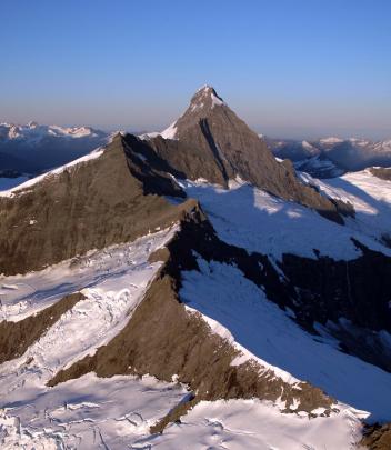
The highest peak of the national park that carries its name, Mt Aspiring (3027m), is often shrouded in clouds that arrive from the west and mass and swirl about the Southern Alps, or Main Divide.
And amid this murk has lain dormant a question that has only recently been answered: was the man who gave the mountain its English moniker in 1857 actually looking at a different peak when he named it?
Known to Maori as Tititea (''Glistening Peak'') or Te Makahi o Tuterakiwhanoa (''The Wedge of Tuterakiwhanoa'', after the Maori explorer) the mountain was, according to various histories, first seen by a European on December 18, 1857, when John Turnbull Thomson was moved to write in his fieldbook: ''At the head of Hawea dist.
About 40 miles is a very lofty snowclad [the snowclad being added above the line of writing] peak which I called Aspiring.''
However, prompted by their own journeys some 150 years later, two Otago men have arrived at the conclusion Thomson must have been looking at another mountain.
A little history: From early in October 1857, in his role as chief surveyor of Otago, Thomson had been surveying inland North Otago. Following a brief break in Dunedin, he set out again on December 7 to explore the headwaters of the Waitaki and Clutha rivers; having crossed the Lindis Pass on December 17, Thomson camped that night on a peak he had named Black Knob Mountain, resuming his journey the next day.
''It was not until noon,'' John Hall-Jones writes in Mr Surveyor Thomson, a 1971 account of his great-grandfather's travels, ''that the succession of ridges terminated abruptly and the snowy mountains of the west coast burst into view''.
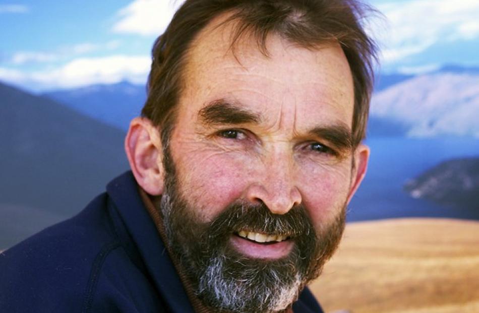
Yet, according to Wanaka photographer and veterinarian Gilbert van Reenen and Dunedin climber Danilo Hegg, the view from Grandview Mountain towards the northwest (i.e.
''the head of Hawea'', as Thomson described it) features another peak, Mt Aeolus, as the dominant focal point.
''I have been up to that exact spot several times and from there, the view of Aspiring is pretty much a non-event. However, on a good day, you get a fantastic view of Mt Aeolus,'' van Reenen says, adding Mt Aspiring is largely obscured by Mt Alta when viewed from Grandview Mountain.
''Thomson had come from the Waitaki, through the Lindis and had named many features along the way. His was the first European view of the land of far-west Otago ...
''He made those observations in December 1857 and often at that time of the year you don't see the summit of Aspiring because it is obscured by cloud. Mt Aeolus is several kilometres east of the Main Divide and is usually clear of cloud.''
Having first had his interest piqued by Thomson's diaries and descriptions and his paintings from a position to the south of Grandview Mountain, which have been reproduced in books about the surveyor by John Hall-Jones, van Reenen contacted the surveyor's great-grandson.
''Even though I suspected he probably wouldn't like my news, I told Hall-Jones I thought his great-grandfather had been looking at a different mountain.
''To the contrary, he accepted what I had found and acknowledged that there were some discrepancies in the diaries.
''His most dramatic response though was, 'you won't believe this, but I've just had correspondence with somebody else about that'.''
That person was Hegg, whom van Reenen knew through the climbing community.
As it transpired, Hegg had his own questions about Thomson's identification of Aspiring. The fact Hegg and van Reenen had arrived at the same conclusion within weeks of one another was entirely coincidental, both men emphasise.
A few years ago, Hegg and a couple of friends had decided to camp on Grandview Mountain ''because, according to the stories, it was from there that Thomson named Mt Aspiring,'' he explains.
''We didn't quite click at the time that it must have been Aeolus that Thomson was looking at, but it is much more visible than Aspiring from that point.
''When I came home I matched photographs I'd taken from Grandview Mountain with the first painting Thomson had made and realised that wasn't done from there at all. It was somewhere around Trig Hill, which is actually about 8km south of Grandview Mountain.''
Hegg, who has a has a degree in engineering and teaches mathematics at Otago Boys High School, tracked down Thomson's fieldbooks, which are held by Land Information New Zealand (they were held in Linz's Dunedin offices until late 2010 but moved to Christchurch following the agency's consolidation).
''Linz were pretty helpful; it was a matter of making an appointment as I couldn't take the historical handbooks home. I was able to photograph the pages and take them home.
''I felt I had to check his maps and logbooks to see if I was on the right track and make sense of it,'' Hegg says.
''I then spent two days reconstructing Thomson's entire system of triangulations on the Lindis Range. What Thomson would have done on the drawing board 150 years ago, we can more easily solve with trigonometry and calculators today.
''Going over Thomson's measurements in the notebooks, it became completely obvious.''
Notably, Thomson hadn't taken a bearing on Aspiring from that historic first climb up Grandview Mountain on December 18, 1857.
In fact, the name Aspiring first appears in his notebook among the bearings taken from Bluenose, about 5km south of Grandview Mountain. However, the mountain he had measured was not Aspiring but, rather, Mt Aeolus.
''Thomson wrote the name 'Aspiring' and included bearings he'd taken with his theodolite - and those bearings were bang on Mt Aeolus,'' Hegg says.
A bearing he later took from the tops on the true right of the Lindis River pointed to a different mountain - the peak that carries the name Aspiring today.
''Once back in his office, while drawing his first map, Thomson would have realised that the two bearings on Mt Aspiring did not intersect where they should have - because they were of two different mountains.''
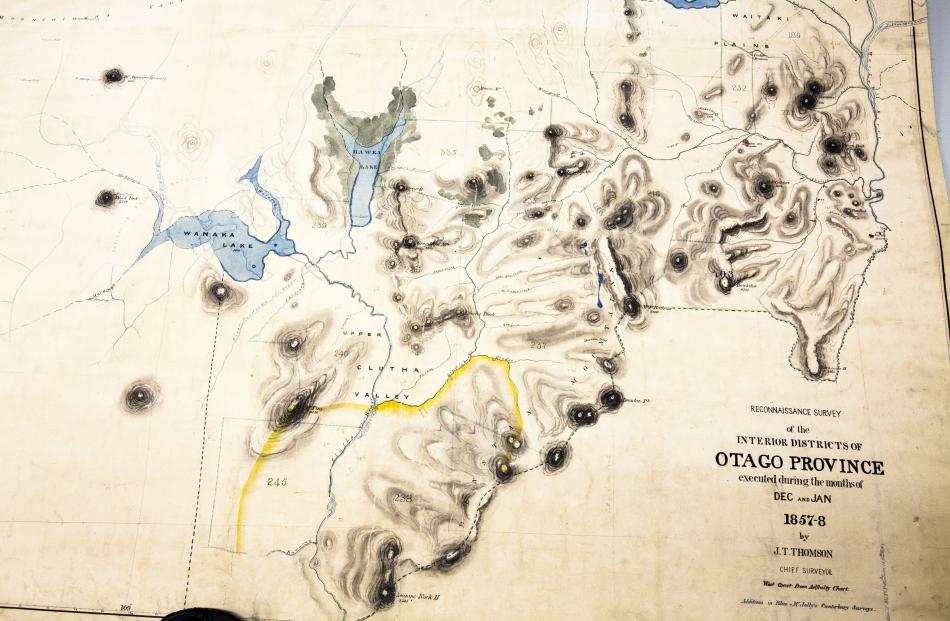
Thomson's first map of the area, drawn by hand in ink and titled ''Map of the reconnaissance Survey of the Interior Districts of Otago Province, 1857-1858'' (held by Archives New Zealand's Dunedin office), provides a clue: there is a question mark after the name ''Mt Aspiring''.
''When I saw the map he'd drawn with the question mark next to Mt Aspiring, I knew I had found a clue that was key to the solution of the puzzle.
''It is the only question mark on his entire map,'' Hegg says.
''Thomson obviously must have been unsure himself. And that was confirmed when I reconstructed the triangulations based on the notes in his logbook.
''That's because the two bearings relate to two different mountains. Hence the question mark on the map.
''This, however, raised another question: how did the name Aspiring end up in its current, correct, location on his map? One bearing is not enough to identify a point on a map.
''Thomson matched his second bearing labelled 'Mt Aspiring' with a bearing on a 'Cloudy Mountain' he had previously taken from near Lindis Pass.
''This is confirmed not only by the fact that the two bearings converge exactly on Mt Aspiring but also by the words 'Cloudy Mountain' scribbled in brackets in his notebook next to 'Mt Aspiring'.
''It would have been impractical for Thomson to retrace his steps and re-survey the area,'' Hegg says.
''The trip he made would have taken him three months by horseback from Dunedin. He had a pretty busy job surveying elsewhere, so to return would have been out of the question, really.''
Despite Hegg and van Reenen's interest in the circumstances surrounding Turnbull's initial naming of Mt Aspiring, both men emphasise they are not interesting in pursuing a renaming of the peak.
''A whole lot of people were worried we'd go to the Geographic Board, but we don't want it renamed or anything,'' van Reenen says.
And Hegg?
''I'm at peace. The questions I had have been completely answered. I'd be more than happy if someone wanted to double-check, but my mathematics are solid.''