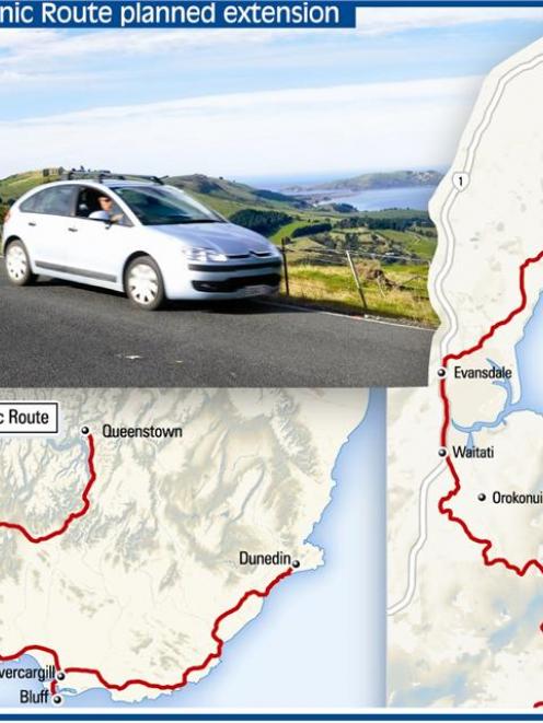
The Dunedin City Council will consider a proposal to add a link to the route, between Port Chalmers and Karitane, providing an alternative scenic route for tourists entering Dunedin from the north.
The work would result in new signs added to existing roads, but could also require roading improvements to cater for extra traffic.
The suggestion was made by a Waikouaiti Coast Community Board working party last month, following a study that began last year, and already had the backing of the Chalmers Community Board.
Waikouaiti board and working party member Andrew Barratt said the aim was to give coastal attractions north of Dunedin "a little bit more of a focus on the tourist map".
The south-bound route would begin at Karitane, off State Highway 1, following the Coast Rd to Evansdale, before rejoining SH1 until Waitati, where traffic would be directed up to Blueskin Rd, past the Orokonui Ecosanctuary to Port Chalmers and SH88.
"It's really about encouraging people to enjoy the sort of outdoors things that we've got on offer - walking, cycling, and things like taking a walk on the Karitane peninsula, which I think a lot of people tend to miss," Mr Barratt said.
"It provides better patronage for existing businesses and possibly it might encourage some small businesses to set up." Infrastructure services committee chairman Cr Andrew Noone said establishing a working party would be considered at the next committee meeting on April 19.
If approved, representatives from community boards - also including the Otago Peninsula Community Board, the council and Tourism Dunedin would be invited to participate.
Cr Noone already received positive feedback from the New Zealand Transport Agency, which was responsible for state highways at either end of the proposed route.
It was hoped a finalised plan could be presented to the subsequent infrastructure services committee meeting on June 14, he said.
The existing scenic route was launched in Tuatapere, in Western Southland, in 1985, and was now supported by regional, district and community tourism organisations across the South, which would be approached, Cr Noone said.
He was confident the work could be completed in time for this year's World Cup, at minimal cost, paid for from within existing council budgets.
Any additional work, including roading improvements, would need to be considered as separate projects as required, he said.
"There could be all sorts of add-ons that potentially would create greater opportunities for local businesses.
"I would see that as being very much a business-driven [project], in partnership perhaps with the community board, to look at add-ons in the future."
He saw no issue with directing extra campervans and caravans on to the proposed route, as the roads to be used were sealed and in "pretty good nick".