Thousands of Aucklanders are still without power and motorists are being warned to take care in the windy conditions.
But the strong south to southwest flow that has bought cold, wet and windy weather to most of the country is set to subside by early evening, MetService said.
Vector indicated there were power outages in South Titirangi, Howick, Greenhith, East Tamaki, Clevedon and Birkenhead, after a short, sharp storm swept through the Auckland region earlier today.
Vector said crews had restored power to around 3,500 customers this afternoon, but 6500 were still without power and extra crews were working on the remaining faults.
The wet, cold and squally southwesterly affected many in the North Island today, said MetService meteorologist Elke Louw.
A warning is in place for strong winds of up to 120 km/h in Auckland, which should subside by about 3pm.
"There are a number of warnings in place for severe gales, as well as a period of heavy snow over the Central Plateau today, but the good news is that conditions do start to improve as we head into Tuesday," she said.
Conditions across the country would clear tonight but temperatures were expected to dip into the low single digits, she said.
"Tuesday and Wednesday look to be the fairest days this week, although there could still be one or two showers around as the disturbed southwesterly flow slowly weakens."
The Interislander ferry services were cancelled this morning because of the worsening conditions in the Cook Strait, with swells close to six metres.
The Aratere was to depart from Wellington to Picton as close to its scheduled departure time of 2.45pm as possible.
However the sailing will be freight only and passengers have been rebooked onto other sailings.
The Kaitaki was scheduled to depart at 9pm and a decision would be made about 4pm as to whether this service would also be cancelled, said senior communications advisor Michael Flyger.
"We expect the full service to resume overnight... Waves are just a bit high for passengers to go comfortably at the moment."Thousands of Aucklanders are without power as a wintry blast sweeping the country brings down power lines across the region.
In the South, motorists were urged to take care on roads as the blast hit.
Snow forced the closure of State Highway 94, Te Anau to Milford Sound, earlier. It has now reopened.
On other southern roads, a combination of ice and strong winds prompted cautions from the New Zealand Transport Agency on SH1, Waitati-Dunedin; SH87, Middlemarch-Outram; and SH85, Kyeburn-Palmerston.
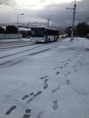
In Dunedin, hill suburb residents had to deal with snow on the ground this morning, while hail and sleet have been falling in many parts of Otago as a strong southwesterly moves over the region.
The snow affected bus services on some of the city's hill routes, causing delays for a time.
Police said there had been a minor crash in Brockville and urged motorists to drive to the conditions.
Further north, the Desert Rd has been closed because of snow coming down "thick and fast", the New Zealand Transport Agency said.
Severe gales were expect to pick up across the day and would affect the east coasts of both islands, as well as central New Zealand and the upper North Island.
The strongest winds could reach 120km/h in exposed places and were forecast for Wellington, the Wairarapa coasts, Hawkes Bay, Gisborne and over Auckland and Northland, MetService duty forecaster Philippa Murdoch said.
Gusts of this strength had the potential to damage trees, powerlines and insecure structures and could make driving difficult, Ms Murdoch said.
In Christchurch, a roof that had lifted off a house on Peterborough St in the strong winds had been secured by fire crews this morning, Fire Service southern communications manager Jill Higgison said.
Winds had also ripped off a panel on the Forsyth Barr building in the central city, Ms Higgison said.
Seas around the country are being whippped up, and large waves likely on the southern coasts of Wellington and Wairarapa, also western coasts of Auckland and Northland.
Heavy rain was also expected across most of the North Island and thunderstorms were possible in eastern parts of the North Island, Ms Murdoch said.
"It should move through fairly quickly. The worst of it will be over by early afternoon."
Heavy snow warnings had been issued in Taihape and Tongariro National Park where snow was expected to fall to between 500 to 600 metres today. Snow was also expected to accumulate to up to 20cm above 1000 metres and fall to low levels across the South Island.
The Rimutaka Hill Road could also be in for a dusting of snow and further falls of to up to 20cm were expected on the Desert Rd, Ms Murdoch said. Motorists were advised to check the status of higher roads around the central plateau before travelling.
"Those cold temperatures will remain for much of the day. We'll see a pretty rapid rise in temperatures tonight and the North Island going into tomorrow morning."
The temperatures were unusual, but not unheard of for this time of year, Ms Murdoch said. "Spring weather does tend to be very variable."
- additional reporting APNZ