A major winter storm system has swept through the southern United States, spawning tornadoes in several states and killing two people in weather-related road accidents.
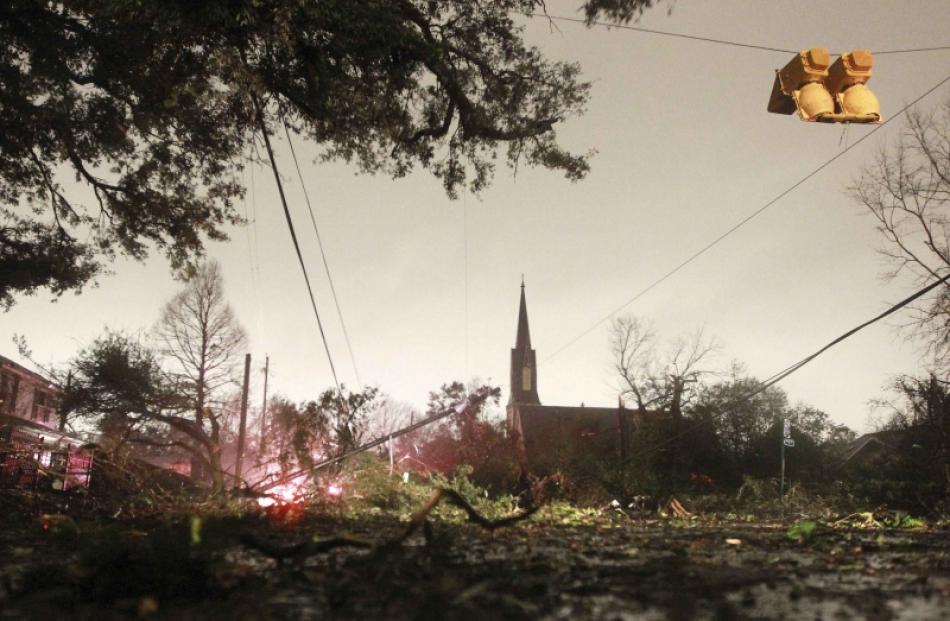
The National Weather Service (NWS) said a tornado struck Mobile, Alabama, home to about 200,000 people, at about 5pm (local time). There were reports of damage to trees and widespread power outages, along with some structural damage, but no injuries or fatalities.
Tornadoes also touched down in Mississippi, Texas and Louisiana, flattening houses and causing some injuries, according to the NWS.
The wild Christmas weather was expected to continue into early Wednesday - the NWS' Storm Prediction Center forecasted the development of "a few strong tornadoes and thunderstorm wind damage over parts of the southeast" this evening and overnight.
It warned that tornadoes at night at this time of year can be particularly dangerous because they are usually fast-moving and obscured by rain and darkness. Areas mostly likely to be hit by strong storms include southern and eastern Alabama, the Florida Panhandle and southwest Georgia, the NWS warned.
The storms also contributed to a 21-vehicle pile-up that shut down a major highway in Oklahoma City and tens of thousands of power outages.
A Texas man died after an accident involving a tree in the road, and another person died in a weather-related accident on I-44 in Oklahoma, according to local authorities.
The storm was expected to evolve into a blizzard from Arkansas to southern Illinois on Tuesday night (local time), with snowfall of up to 30cm in some areas, according to Accuweather.com.
Accuweather.com senior meteorologist Kristina Pydynowski warned on the website that travel will be "extremely treacherous, if not impossible, as the snow clogs roads, such as interstates 24, 55 and 57, and the blowing snow severely lowers visibility."
The Indiana governor's office issued an advisory on Tuesday evening that "non-essential employees" who live in areas where snow emergencies have been declared do not have to come to work.
The snowstorm will shift on Wednesday to the eastern Great Lakes and northeastern region, with a blizzard warning in effect for Cleveland starting at 7am on Wednesday, forecasters said. Cleveland could get up to a foot of snow, according to the NWS.
Southern Indiana is under a blizzard warning starting early Wednesday morning, according to NWS meteorologist Crystal Pettet. Indianapolis could see its biggest snowfall in four years, with a possibility of 25cm to 30cm of snow.
"Conditions should be pretty bad in time for rush hour," Pettet said.
Christmas snowfall
In the town of McNeill in southern Mississippi, an apparent tornado destroyed 12 homes and injured eight people, though none of the injuries appear life-threatening, said Danny Manley, director of the Pearl River County Emergency Management Agency.
Manley said the homes could not be rebuilt, as some had lost roofs and their top stories and one was smashed by a tree.
Another apparent tornado hit Centreville, Mississippi, in the southwestern part of the state, injuring one person, destroying a trailer and heavily damaging other homes and buildings, according to Tim Destri, a NWS meteorologist in New Orleans.
A tornado destroyed a building 21km southeast of Crockett, Texas, and a bank lost a section of its roof, according to Accuweather.com.
Freezing drizzle overnight led to 10 separate collisions on Interstate 40 in Oklahoma City early on Tuesday, said Betsy Randolph, a spokeswoman for the Oklahoma Highway Patrol. The city also got a rare Christmas snowfall.
The 21-vehicle pile-up included three tractor-trailers and shut down the westbound lanes for about five hours, she said. Twelve people were taken to hospitals, and troopers were checking on the severity of their injuries.
Ahead of the storm's path, parts of eastern West Virginia are under a winter storm warning. Ice accumulations of up to half an inch (1.25 cm) are expected in higher elevations, the NWS said.