• Mayor tells of raging torrents
• Send us your flooding photos
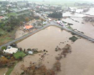
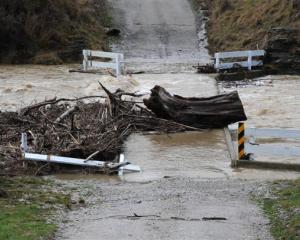
Widespread disruption is expected to continue today, with motorists urged to stay home and travel only in emergencies as flooding affects roads and bridges throughout the province.
More than 150mm of rain had yesterday fallen in inland Southland since noon on Sunday, and a further 15mm to 25mm is expected in parts of inland Southland and Central Otago this morning.
The Oreti River was expected to spill over and threaten properties around the Central Southland town of Winton overnight, which was flooded in November 1999, and landowners in the area had been contacted.
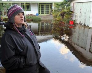
There were no plans last night to evacuate residents.
The peak of the flood was expected to pass through Winton early this morning and reach Wallacetown - near Invercargill Airport - between 10am and noon.
Winton Community Board chairman and local publican John McHugh said last night he had just completed a drive around the area, which until the weekend was "extremely dry".
"It is looking a bit scary, to be honest.
I would like to see it a bit lower."
The Oreti River was "spread from stopbank to stopbank" and there was surface flooding on farmland surrounding the town, much of which had converted to dairying in recent years, he said.
Mossburn Volunteer Fire Brigade acting chief officer Lance Hellewell said much of the surrounding area was affected by surface flooding, with farmers moving stock to higher ground.
"There is a lot of run-off and a few creeks where there has never been creeks before."
Stopbanking systems on other Southland rivers, including the Aparima, Mataura and Makarewa were expected to contain flood flows, however widespread flooding of farmland was expected, Environment Southland catchment manager Noel Hinton said.
The flooding was not expected to threaten urban areas, he said.
The council was watching for flooding of Invercargill Airport.
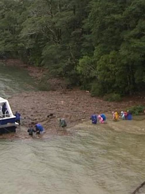
Senior Sergeant Bruce Terry, of Invercargill, said police located a 49-year-old hunter near the Aparima River shortly before 5pm yesterday, after the Nightcaps man failed to make a rendezvous.
The man was found by a Southern Lakes helicopter, and was transported by jet to Southland Hospital.
"He was very cold but is in a comfortable condition," he said.
The Department of Conservation continues to monitor the Young River and the rising levels of a natural dam in the upper north reaches of the valley.
Doc Wanaka area manager Paul Hellebrekers said no "code red" warning had been issued "yet".
The area remained on a "high river alert" given the extended period of rainfall.
Doc staff were monitoring the level of the Young River dam by way of an on-site station, rain gauges in the area, and also a visual assessment of the Makarora River and its tributaries, Mr Hellebrekers said.
A reading at 4pm yesterday had the dam at 580.4m above sea level, down from a high of 581.3m on Sunday.
Makarora's ORC-recorded rainfall was 85mm during the past 24 hours.
A rain station at the Matukituki River mouth at West Wanaka recorded 55mm of rain during the past 24 hours.
The level of Lake Wanaka had risen about 50cm during the past 24 hours to post a recording of almost 278m above sea level, at 4pm yesterday.
Flooding closed several roads around Glenorchy and the Paradise Valley, as continual rain kept Queenstown Lakes District Council roading contractors busy yesterday.
Council spokeswoman Meaghan Miller said Greenstone Station Rd was "completely impassable".
"Deep flooding" at Kinloch Rd near the lodge had closed the road, and the unsealed section of the Glenorchy Paradise Rd was closed.
Routeburn Rd reopened yesterday afternoon after being closed for a period during the extended period of rainfall.
The Rees Valley Rd was accessible past Invincible Creek, but only by 4WD vehicle, Ms Miller said.
A section of about "the last 100m of Wanaka-Mt Aspiring Rd" was inaccessible because a flooded ford on the road was impassable, she said.
"Frittering" and road debris from slips affected the Crown Range Rd between Queenstown and Wanaka, she said.
• The Otago Regional Council website showed the Pomahaka River at Burkes Ford flowing at 63.326cumecs at 6.30pm yesterday.
Niwa's environmental data explorer New Zealand site states the Pomahaka River at Burkes Ford has a mean flow of 27.18cumecs.
The river's level had been monitored during the day by Downer EDI Works.
Clutha area manager Darrell White said they were "just checking to see what was happening."
The Otago Regional Council's water information for the lower Clutha showed 26.5mm of rainfall in the last 24 hours.
Road closures
• SH94 Mossburn to Te Anau (Mararoa Bridge to Whitestone Bridge)
• SH94 Te Anau to Milford Sound (Cascade Creek to Milford Sound)
• SH97 Five Rivers to Mossburn
• North Makarewa Grove Bush between Horman and Thomlinson, Affleck Rd, Lowther Rd, Ellis Rd, Felton Rd, Roy Rd, Council Rd, Makarewa, Lora Gorge Rd (Winton), Nokomai Rd and Cainard Rd (Garston Area), Kakapo Rd from Dales Rd, Waikouro-Wairio Rd, Dipton South Hillend Rd (between Hundred Line East Rd and Benmore Rd), Te Anau Golf Course Rd, Te Anau Upukerora Rd, Te Anau Ramparts Rd (from the Te Anau Mossburn Highway to Mt York Rd)
• Caution advised for SH6 Kingston to Athol
More heavy rain predicted
• Rainfall measuring 793mm has doused Fiordland National Park and the Southland district since Saturday night.
• Several frontal bands embedded within a strong moist northerly flow are expected to bring further heavy rain to Westland and Fiordland today, with significant spillover, about 150mm, into the headwaters of the Canterbury and Otago lakes and rivers.
• Rainfall expected in the 33 hours from 3pm yesterday to midnight tonight includes: Fiordland and Westland from George Sound to Franz Josef: 150 to 200mm, especially about the ranges north of Jackson Bay.
• Westland north of Franz Josef to Otira: 250 to 350mm.
• Inland Southland, mainly north of Winton and Mataura: More than 150mm has fallen in some inland areas since midday Sunday; 30 to 50mm is expected to midday today.