

The solar blow torch was firmly aimed at the south of the country today, and some of the hottest places were around Dunedin.
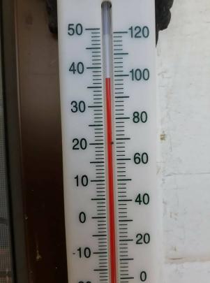
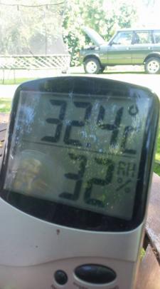
MetService and weatherwatch.co.nz this afternoon both showed temperatures around the 33degC mark for several places on the Taieri, including Dunedin Airport and Outram, while unofficial readings from ODT Online readers showed the mercury above 35degC in several places.

Earlier today the so-called 'Mosgiel microclimate' was in full force, with temperatures reaching 30degC on the Taieri Plain before Dunedin city reached 20degC.
However, by 2pm Dunedin had reached 28degC, closing the gap on Dunedin Airport, which was on 31.8degC.
A Weatherwatch spokesman earlier said the heatwave could see temperatures exceeding 35degC in the southern half of the South Island through some valleys, but by 5pm those highs had not been reached.
Alexandra was tipped to be the hottest place in New Zealand today, with 33degC.

Weatherwatch.co.nz head analyst Philip Duncan said a low in the Tasman Sea would roar into life over the next 24 hours before falling apart as it moved on to the country mid-week.
The low would peak in intensity tomorrow when it hadn't reached land but it would still bring wind, rain and showers across New Zealand.
He said the low would encourage more of the hot, humid airflow from the sub-tropics fuelling the heatwave in the lower South Island today and tomorrow.
Meanwhile, a thunderstorm watch has been issued for violent storms to rock the central North Island after lunch as warm, humid conditions and light winds combine to produce towering thunder-charged clouds.
MetService says the main risk of storms today is about southern and eastern Taupo, Taihape, inland and southern Taranaki, Whanganui, Manawatu and the western ranges of Hawke's Bay.
The forecaster said the thunderstorms, which were expected to strike between about 3pm and 10pm, could be severe with torrential downpours and small hail.
It warned localised deluges could lead to flash flooding and prove hazardous to those on the roads. Streams and rivers and narrow valleys were at risk of suddenly becoming inundated, with the threat of slips.
The thunderstorms were expected to die away late this evening.
Yesterday nearly 2000 bolts of lightning were recorded across the central North Island ranges as storms hit throughout the afternoon and evening.
The forecaster said the thunderstorms, which were expected to strike between about 3pm and 10pm, could be severe with torrential downpours and small hail.
Related Stories


Comments
Mercury is a poisonous heavy metal, it is not a temperature scale.
It has been illegal to use mercury in thermometers for decades. The examples you actually show are two electronic and one red alcohol thermometer.