MetService this evening advised that the red warning for mid-Canterbury had been lifted, but said an orange rain warning remained in force for the far north of Canterbury and southern Marlborough.
The forecaster said rain had now eased to showers across much of the region, heavy rain was still possible about and north of Cheviot, and in Marlborough about and south of Kaikoura until midnight. Rain should then ease to showers in this area.
Any remaining showers through Canterbury and southern Marlborough should clear by early Tuesday afternoon, and no further rain is expected for the remainder of the week.
MetService meteorologist Angus Hines earlier said rain was easing across Canterbury, but caution was still required around the region's swollen rivers and waterways.
"We've got that [heavy rain] warning in place, 7pm is still the cut-off time, when it's expected to lift.
"After that, things should be at least in terms of local rainfall noticeably decreased, however, the rivers of course will still be running high and they can stay high even after the local rainfall finished.
"There will be potential for further issues surrounding those high, swollen rivers."
Residents in low-lying areas of The Pines Beach were this afternoon still being evacuated after the Waimakariri District Council issued an "evacuate now" notice on its social media pages this morning.
Emergency services were knocking on residents' doors this afternoon, the district council said in a 4pm update.
Residents in other parts of Canterbury have been warned to prepare for an evacuation should it be needed.
The NZ Transport Agency said that rain was easing but it was unlikely some key roads, including State Highway 1, would reopen today.
With rain lessening south of Christchurch, floodwaters on roads were expected to recede in those areas later today, Waka Kotahi NZ Transport Agency journey manager Tresca Forrester said.
However, the Selwyn/Waikirikiri River had caused deep flooding on SH1 at Dunsandel, which meant the highway link south of Christchurch was among the roads unlikely to open today.
The ongoing situation came as residents in Canterbury woke up to a region-wide state of emergency today after the weekend's torrential rain caused rivers to burst their banks and forced mass evacuations.
The weather event has been labelled a one-in-100-year event and resulted in a rare red warning being issued by MetService late last week - only the second time such a warning has been put out by the authority.
Some of the worst flooding occurred around Ashburton, and this afternoon residents were urged to keep bags packed as river levels drop in the area.
River levels have been falling but it could take two or three more days to drain and people need to keep their bags packed in case stopbanks burst, Ashburton District Mayor Neil Brown says.

Officials had been meeting this morning in response to the flooding disaster that has hit Canterbury since the weekend due to heavy rainfall.
In an update on flooding in the region, Brown spoke alongside council chief executive Hamish Riach.
He said while it had stopped raining the river was still full and there was still pressure on some spots.
Residents were still required to have a bag packed and be prepared to evacuate, he said. It could be another two or three days before the catchment dropped back to normal levels.
Riach said it may feel like it's "just a rainy day" but the pressure on the rural area was high with a lot of surface flooding. There were other issues including floodwaters getting into the wastewater system.
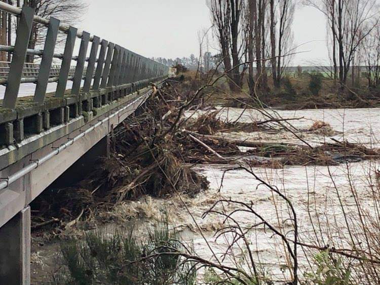
Four bridges were gone, and there were numerous roads where the seal had been lifted off the road, Brown said.
Seventeen roads were closed, including the Gorge Bridge and Rakaia Bridge - the roads to Christchurch.
Residents should avoid any unnecessary travel and remain at home, Brown said.
"There is a lot of damage, a lot of water has been swirling around, creating holes in the road, and if there's water still in them, you won't see them and your car will just drop into them."
Waka Kotahi's Forrester said rain was continuing in some places and there were areas they needed to assess, "for example SH73, Porter's Pass to the West Coast, which will remain closed".
"Engineers are assessing the two Kowai River bridges and Porter River bridge approaches on SH73 today, and there is a lot of river shingle covering this highway which needs to be shifted before it can reopen.
"The Lewis Pass via Waipara, SH7, the other route linking Canterbury and the West Coast, is open."
She urged people to avoid travel in Canterbury today given the changing situation. People should check Waka Kotahi's South Island Facebook page before heading out, she said.
"Many local roads are also under water, so your local council's Facebook pages and Emergency Management pages are the best places to check."
People were urged not to drive through floodwaters even if they were subsiding as they could have hidden hazards.
Earlier story
People in parts of Canterbury were this morning being ordered to head to higher ground as weather authorities extend a heavy rain warning for the region.
Between Amberley and Geraldine, the warning is in place until 7pm today, MetService said.
News of the extension came as Pines Beach, a settlement just out of Kaiapoi in North Canterbury, was being evacuated.
Civil Defence is requiring all residents in the low-lying areas of Pines Beach, particularly around Dunns Ave, to leave their homes.
A flood gate is stuck open and it is feared areas of the settlement may be flooded.
Kairaki, the neighbouring beach settlement which is near the north bank of the Waimakariri River, has already been evacuated.
Residents on the higher sections of The Pines Beach could stay if they wished, Civil Defence said, but it warned they may become isolated for some time if Beach Rd, from Kaiapoi, floods.
A message from the Timaru District Council's Facebook page said anyone in a low-lying Coopers Creek area should go to higher ground immediately.
Evacuees can go to friends or family or to the Temuka Civil Defence Centre - Alpine Energy Stadium situated in the Temuka Domain or the Geraldine Civil Defence Centre situated at Geraldine High School.
Latest update is that most river flows are steadily dropping with the exception of the Temuka and Opihi River which is still fluctuating.
The council advised against driving through flood water because of the risk flooding had caused large holes in the roads. The flood water should be treated as unsafe and contaminated.

Waimakariri Civil Defence is urging residents to take extreme care on the roads and to keep up to date with flooding information throughout the day.
‘‘While the rain may be lighter, river levels remain dangerously elevated and it will take some time until the risk is gone.
‘‘If all possible, residents are asked to stay off the roads and avoid travelling. If people do need to drive, they should take it slow and leave plenty of following distance between vehicles. People should avoid driving through flooded areas and in the immediate vicinity of rivers.
"If evacuations are required, an Emergency Mobile Alert will be sent to the affected areas and emergency services will be deployed. Residents should keep their mobile phones switched on and close to hand,'' a Civil Defence spokesman says.
The river risk led to two areas being evacuated late last night and early this morning by emergency services. Fire and Emergency New Zealand (Fenz) crews evacuated approximately 113 properties in the Oxford and Mount Thomas Road area near the Ashley River.
Fernside residents between Oxford Rd/Mount Thomas Rd and the Ashley River – from Mertons Rd up until the junction of the Okuku and Ashley Rivers who had previously evacuated are now able to return to their homes, the NZ Herald reported this afternoon.

A further 133 properties were evacuated in the Eyre River area overnight, however with river levels dropping, residents in this area are also returning home.
Waimakariri Mayor Dan Gordon told Morning Report the Ashley and Kairaki rivers were still causing concern and residents should remain on alert.
Gordon said anyone who did not have to go out should not.
The Waimakariri District Council says a Civil Defence Centre at Rangiora Baptist Church is open for people who need somewhere to stay.
About 700 people from 300 properties in the Waimakariri and Selwyn districts were evacuated as a precaution overnight if rivers in those areas were to break the flood blanks.
Mandeville Sports Centre, near Swannanoa, opened up as a Civil Defence post and refuge location about 7pm yesterday.
Centre manager Richard Belcher said about 20-30 people without access to their homes had congregated at the centre north of Christchurch, some opting to rest in their cars or campervans.
This morning the Selwyn River has breached its banks.
 talks with police at Digby's Bridge, where stopbanks were keeping floodwaters in the north branch of the Ashburton River. Photo: Ashburton Courier")
Ashburton water levels
Floodwaters in the Ashburton River have dropped a little but authorities remain on full alert as Mid Canterbury’s red rain event continues to play out.
Attention is focusing on the integrity of stopbanks that line the north and south branch of the river. They have kept most of the floodwaters in the river channel, though surface water is also a problem around the district.
Farmers are checking the state of their paddocks and feeding out stock, Ashburton District Council staff are checking the state of bridges, roads and other infrastructure and schools are closed.
Some businesses in Ashburton have also closed for the day, while others are allowing staff to work from home.
People are being asked to stay home and off the roads, but rubber-neckers are still a problem.

The town’s wastewater treatment pond at Wilkins Road has flodded and potentially contaminated water is mixing with floodwater.
It may be flowing into Carters Creek, which feeds into Lake Hood, the district’s recreational waterbody.
People are being told it is a public health risk and to avoid contact.
Drinking water has been tankered to Mt Somers and Methven, where boil water notices were in effect.

The Ashburton River had dropped from a peak of 1448 cumecs to 1237 cumecs at 11am today.
A welfare centre set up at the Hakatere marae was helping people who had self evacuated.
Firefighters respond to water rescues
Southern fire communications shift manager Simon Lyford said they had helped police with "a couple" of water rescues overnight, as well as helping police and Civil Defence teams with precautionary evacuations.
Two people have had a lucky rescue after their car became stuck in flood water in Canterbury.
Fire crews were called to the incident on Highfield St in Dunsandel at about 6.15am.
A Fire and Emergency NZ spokesman says the car was a rental and the pair were heading towards the airport.
They tried to avoid the water by driving around it but became stuck.
Crews were able to free the vehicle and nobody was injured, the spokesman said.
Crew aboard a RNZAF NH90 helicopter rescued three people from floods in the Ashburton area overnight. One man, who was in a tree surrounded by floodwater in the vicinity of Darfield, was rescued after he jumped from the tree and attempted to swim and was swept away.
The crew scoured the water for about 30 minutes before locating the man and plucking him to safety.
The crew also rescued an elderly couple from the roof of a car near Ashburton Forks.
MetService's Red Severe Weather Warning has been extended in parts of Canterbury until 7pm this evening, extensive rain is expected to continue through the afternoon.
Ashburton, Selwyn and Timaru all declared states of emergency yesterday before a region-wide state of emergency was declared by Canterbury Civil Defence just before 5pm.
The Timaru District Council has just announced a district-wide conserve water notice for all district water supplies as staff monitored the situation.
The New Zealand Army has 16 vehicles and 30 personnel in the following locations:
- Ashburton: 17 personnel, 7 vehicles (including Unimog, HX58 and a LOV ambulance) – 24 adults, 6 children, 6 dogs, 6 cats evacuated
- Timaru: 6 personnel, 4 vehicles – 6 adults evacuated
- Waimakariri: 2 personnel, 2 vehicles
- Selwyn: 5 personnel, 3 vehicles – 20 adults evacuated
- Christchurch: 1 personnel
- by RNZ, Robyn Bristowe & Linda Clarke, additional reporting NZ Herald