Efforts to contain a large scrub fire which ripped through more than 300ha at Arthurs Pass this week may take longer than initially anticipated, after rising temperatures saw hotspots flare up yesterday afternoon.
Fire authorities will today use thermal imaging technology to identify any hidden hotspots in the burnt and blackened terrain at Flock Hill near Craigieburn Forest Park in Canterbury.
But the blaze is expected to take "a lot longer than initially anticipated" to get under control, a Department of Conservation spokeswoman said this morning after conditions took a turn for the worse yesterday afternoon.
The 8km perimeter was 80 per cent contained, but flare-ups had made getting it under control much more difficult, she said.
The fire has been raging since Monday afternoon when it quickly spread to 330ha and threatened livestock and closed State Highway 73, which is the main road between the West Coast of the South Island and Christchurch, for a period.
A good start to getting the fire controlled yesterday "quickly deteriorated" in the afternoon with increasing temperatures and winds, DoC said.
The afternoon temperature soared from 20C to 27C in an hour, with increasing winds, causing quite a few fires to flare up again, DoC fire officer and incident controller Bruce Janes said yesterday.
Three helicopters with monsoon buckets were called back into action and were expected to work until nightfall.
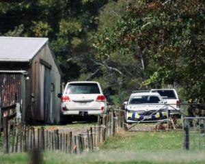
Two cyclists and a tractor driver who were seen in the area of SH73, and were believed to have been key witnesses, have come forward to police.
The cyclists also posted a description of what happened to the Trans NZ Enduro Facebook page, saying they were "oblivious" to being sought by police.
"We have spoke[n] to the police now and are the key and only witness to exactly how this happened. We are still in shock with the extent of this and how oblivious we were that we were wanted in the media as we were out for 7hrs riding the trails yesterday," one post said.
The cyclists, who posted a photograph of the burgeoning fire, said they then "raced to the top of the hill to get cell coverage and called the fire department".
"We can't believe we were the ones that saw this fire start and and what it turned in to ... So dry here, we couldn't believe the rate it was spreading! We climbed that hill pretty fast and got out of there!"
The pair were staying at Castle Hill Village where there was "no TV or news", and went out for a long ride the next day "not knowing police were looking for us".
"We assumed they would have known what happened! But we made our statements last night of what we saw," the pair said.
"We still can't believe we saw it happen right in front of us and how fast it spread. We sure rode up that hill fast!
"It wasn't lit deliberate but that old tractor shouldn't have been driving without a spark arrestor with all the fire bans right now."
An investigation into the cause of the fire is still ongoing.
Earlier this week police said the fire appeared to have been started in four separate locations along the eastbound bank next to SH73.
Fire threat throughout north Canterbury:
As well as a complete fire ban throughout Canterbury, motorised vehicle access to the following forest and/or mountain-based recreation areas are now closed until further notice:
* Mt Grey/Maukatere Conservation Area within Ashley Forest (inland from Amberley). All public access, including walking and mountain biking, is closed.
* Hanmer Forest - McIntyre Rd and Chatterton Rd (off Jacks Pass Rd) and the car parking area in the Woodland Reserve accessed from Jollies Pass Rd closed to all public vehicles.
* St James Conservation Area - Edwards valley 4WD track closed to all motorised vehicles from Saturday January 31. Foot, horse and mountain bike access still permitted.
* Molesworth Rd closed to all public access from 7pm Wednesday February 4, until further notice.
- Patrice Dougan of NZME. News Service


