Winter is well and truly here, with many in the South Island experiencing bone-chilling temperatures, snow and frosts, and dangerous roads.
Black ice meant conditions were dicey on roads on Sunday - particularly in Canterbury where there have been several crashes - but also in Dunedin, Queenstown and Wanaka. Road users are warned to drive to the conditions or consider not travelling.
MetService meteorologist Andy Best said on Sunday afternoon the cold front was now "well up north" and the whole of the country was lying under a south-westerley cold air stream.
"There are quite a number of showers still around, particularly over southern parts of Fiordland and Southland and Clutha, and also all up the West Coast of the South Island," he said.
"Some of those showers [will be] quite heavy between Fiordland and Buller, and they may be laced with hail as well ... as the day progresses, more so this afternoon and this evening."
Care should be taken on the Crown Range Road, linking Queenstown and Wanaka due to snow and ice. The road has been gritted, as had other areas crews identified as looking frosty.
Road users should also take care through the Kawarau Gorge (SH6) due to black ice.
In Central Otago the roads were mostly dry, with morning temperatures between -5°C and -3°C. However, ice is likely on bridge decks, shaded areas and hill sections. These have been gritted, a district council spokeswoman said.
Danseys Pass Road is closed (from the gates past the Danseys Pass Hotel) due to snow and ice.
Tekapo got the worst of it overnight at -6.6C, with Pukaki Airport close behind at -5.9C and Alexandra down to -4.8C, according to MetService.
MILFORD ROAD OPEN, SNOW FOR ALPINE PASSES
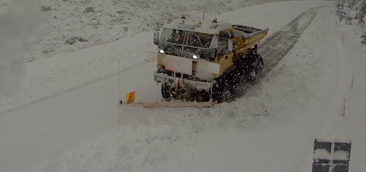
The Milford Road (State Highway 94) reopened from Te Anau to Milford Sound about midday on Sunday after heavy snow was cleared.
Snow had settled to lower levels and was more widespread than forecast for the morning, Milford NZTA advised.
Snow showers were continuing and road users should expect some long delays to allow for snow clearing operations in the afternoon.
Conditions were expected to improve later on, but chains must be carried from from East Gate (Hollyford) to West Gate (Chasm) from 4pm today and overnight.
Snow showers were expected on alpine passes on Sunday, MetService said.
Arthur's Pass (SH73)
A period of snow is likely from late in the morning and into the afternoon. From 11am to 4pm, just 1cm or less of snow may may settle near the summit of the road.
Lindis Pass (SH8)
A few snow showers are expected during this Sunday morning. From 8am to 11am, only 1cm of snow may settle near the summit of the road.
Haast Pass (SH6)
A few snow showers are likely about the summit of the road in the morning but little if any snow is expected to accumulate.
Lewis Pass (SH7)
A few snow showers are likely near the summit of the road in the afternoon, but little if any snow is expected to settle on the road.
NORTH ISLAND
Today was also expected to be colder than Saturday around the North Island, with showery weather expected for much of the island this morning.
And although the sun is expected to break through this afternoon it may not bring much warmth, with upper North Island temperatures struggling to reach the mid-teens.
Scattered showers were expected in Coromandel, Auckland, Northland, Bay of Plenty, Gisborne and Hawkes Bay before becoming fine.
The rest of the North Island can expect fine weather from earlier in the day, apart from a few light showers sticking around between Manawatu and Taranaki.
Forecaster Weatherwatch says the coming week will be drier than normal but rain should return the following week, bringing June's rainfall totals closer to normal for the north of New Zealand.
- ODT Online and NZ Herald