MetService today issued a heavy snow watch for eastern and southern parts of the South Island below the Waimakariri River in Canterbury, saying a front would hit tomorrow evening and continue to bring snow and bitterly cold conditions through to Monday morning.
Road snowfall warnings were in place across the South Island, including SH1 from Dunedin to Waitati where snow was likely to accumulate above 200m.
From 8pm Sunday to 6am Monday 4cm to 8cm could accumulate about the summit of the road, with lesser amounts to 200m.
MetService said the complex low and associated fronts were expected to move east over the country during Sunday and Monday, bringing snow to the South and heavy rain to central parts of the country.
"People are advised that strong cold southerlies combined with snow is likely to create blizzard conditions about higher ground during this time.
"This [severe weather] watch is for significant amounts of snow about southern and western Fiordland, Southland, Otago, and Canterbury south of the Waimakariri River during Sunday evening and Monday morning.
"In addition, this watch is for heavy rain about Mount Taranaki and the Tararua Range."
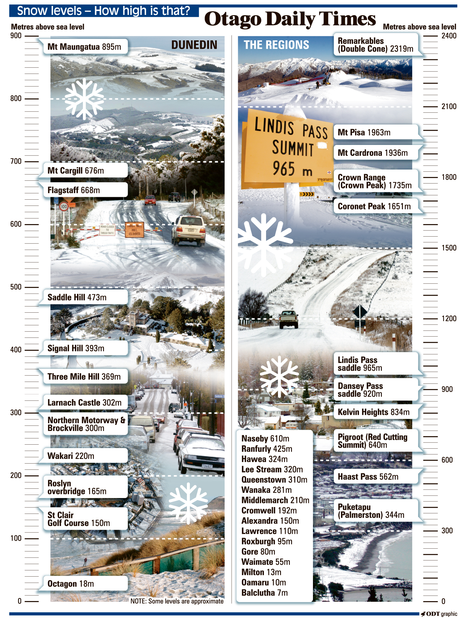
The heavy snow watch for Southland, western and southern parts of Fiordland, and Otago (excluding north Otago) was in place for 12 hours from 6pm Sunday.
Snow was expected to lower to 300m to 400m during Sunday evening, then to 200m early Monday morning.
Significant accumulations were likely above 600m, with the possibility that snow accumulations could approach warning amounts above 400 metres.
The heavy snow watch for North Otago and parts of Canterbury south of the Waimakariri River was in place for 17 hours from 6pm Sunday.
Snow was expected to lower to 400m Sunday evening, then to 100m to 200m during Monday morning.
Significant snow accumulations were expected above 600m, and accumulations could approach warning amounts above 400m.
Snowfall warnings are in place for the following roads:
Lewis Pass (SH7)
Arthur's Pass (SH73)
Porters Pass (SH73)
Haast Pass (SH6)
Lindis Pass (SH8)
Crown Range Road
Milford Road (SH94)
Dunedin to Waitati Highway (SH1)