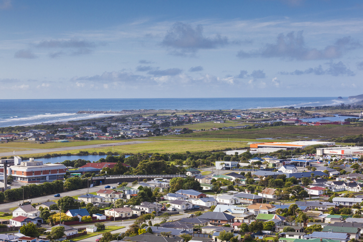
The fault, which runs about 600km up the western side of the South Island between Milford Sound and Marlborough, poses one of the biggest natural threats to New Zealand - especially the West Coast, Canterbury and Otago.
It has a clear geologic record of rupturing around every three centuries - and 2017 marked the 300th anniversary of a magnitude 8.1 quake that shunted the fault's western side eight metres further north in a matter of seconds.
Studies have suggested a big quake could block South Island highways in more than 120 places, leave 10,000 people cut off, and cost the economy about $10b.
Different forecasts have put the probability of a future Alpine Fault quake measuring over 8.0 as high as 65 per cent within the next 50 years - and almost 85 per cent over 100 years.
A rupture of the fault was therefore considered inevitable, with severe damage predicted to the built environment - especially to infrastructure.
Following a 2019 study, undertaken by University of Canterbury disaster risk and resilience researcher Alistair Davies, which gauged potential infrastructure damage over time periods ranging from a day to a decade, scientists set out to look at transport specifically.
As part of the Resilience to Natures' Challenges National Science Challenge, University of Auckland engineering researcher Mohammad Aghababaei has developed a sophisticated model pulling together some 541 "traffic zones", transport data around commuting, tourism and freight, and a host of other parameters.
Simulating the impact of an M8.0 earthquake on the road network, he found that almost all inter-district trips and some local ones in the hardest-hit Buller, Grey and Westland districts wouldn't be possible for at least a week after the quake.
After the first day, 70 per cent, 86 per cent and 81 per cent of trips by heavy vehicles like trucks in those respective districts couldn't happen.
As happened after 2016's Kaikoura Earthquake, travellers would put more pressure on alternative routes - and the model calculated the traffic flow on SH1, between Marlborough and SH7, would have swollen by a third a week on.
SH6, connecting Nelson and Marlborough, could also see 25 per cent more traffic. And, except for a small part of SH6 connecting Greymouth to Hokitika, the rest of that highway linking SH65 on the north, to Lake Hawea near Queenstown on the south, would also be inaccessible.
On the south-west part of the network, the whole of SH94 connecting Milford Sound to Te Anau would also be disrupted.
According to Davies' study, six months after the earthquake, many corridors would be accessible for one to two days a week, including SH65, SH7, SH69, and SH6 connecting Hokitika to Franz Josef.
But SH73, and some parts of SH6, connecting Westport to Greymouth, and Franz Josef to Lake Hawea, would remain shut.
SH65 and SH7, particularly, would be seeing much higher flows than normal because of road closures elsewhere.
"The main impact on travellers would be increased travel time due to the increased distance travelled because of the closures," Aghababaei said.
"Travel times to Queenstown, for instance, would increase by around 170 per cent, 28 per cent, and 54 per cent from Westland, Buller, and Grey, respectively, compared to normal."
Aghababaei said the Kaikoura event had already offered a "unique opportunity" to put road network models for the South Island to the test.
"While conventional network analysis methods are employed with a degree of uncertainty in travel demand behaviour in a post-disaster scenario, the validation of the network using post-disaster travel data can help quantify the reliability of the simulation outcomes."
"This means that rebuilding damaged parts of the highway network would also take many months," said Pete Connors, the agency's system manager for the West Coast and Canterbury.
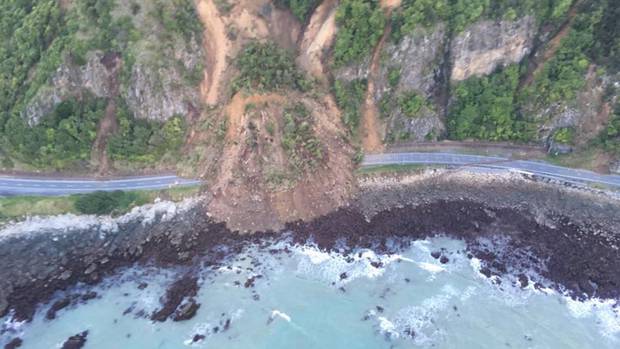
He pointed to risks like rockfalls, slips and rivers and creek beds emptying and forming new courses, as was seen in the Kaikoura earthquake, and even this year's February storm in Fiordland.
"Bridges, which tend to be at narrow river or creek crossing points, are particularly vulnerable in this scenario," he said.
"Whilst we do have emergency response plans based on widely agreed principles, we also have to be ready to respond based on the effects of an earthquake in reality, deploying resources to places where they can do the most good and also be aware that we cannot put people into areas where their lives are endangered."
More widely, scientists, authorities and emergency planners have been working together under a sweeping, nationwide effort called Project AF8.
The project has developed scenarios so South Island communities can plan how they might respond to impacts such as road closures, power losses, dislocation, fatalities and injuries.
Based on the first seven days of emergency response, AF8's planning covered such things as how to shelter tens of thousands of stranded people – and how to provide immediate medical care.

Meanwhile, a six-metre long orange underwater robot is flying through the Kaikoura Canyon for the next month collecting information on how the canyon has changed since the 2016 earthquake.
The technology-laden AUV – or autonomous underwater vehicle – is being deployed from Niwa research vessel Tangaroa with the information collected expected to shed light on what happens to marine areas like this.
Voyage leader and Niwa marine geologist Dr Joshu Mountjoy said this was the first time this technology has been used to survey submarine canyons in New Zealand waters and information collected will lead to new understanding relevant to many of the world's continental margins.
"Submarine canyons are the bridge between the land and the deep ocean, connecting sedimentary systems, capturing carbon and supporting rich ecosystems," he said.
"We have little knowledge of what happens to these marine hotspots after massive disturbances like the Kaikōura Earthquake and so we need to make the most of this opportunity."
The AUV was programmed from the ship and then carries out its surveys while the team on board can resume other scientific work.
The focus so far has been on the middle to lower canyon, about 20km off the Kaikōura coast.
It was flying at 50m above the seafloor, sending back data in higher resolution than has ever previously been possible.
"Our earlier surveys were conducted from the ship which is 2000m away from the seafloor," he said.
"We have never collected AUV data or deployed sediment traps in our canyons, so this is a first. But we hope the start of a new era of high-resolution canyon observations."
Two Niwa surveys since the earthquake discovered large areas of the Kaikoura Canyon drastically changed.
An enormous amount of mud and sediment – estimated to be about 850 million metric tonnes – was shaken off the canyon rim and then flowed down into the canyon channel causing a powerful "flushing" of sediment out to the deep ocean.
"We are mostly interested in understanding the physical process that has removed such a huge amount of sediment and rock from the canyon," Mountjoy said.
"This is a rare opportunity because we know from our previous work that there has a been a very large change recently and this is unusual in the deep ocean."
This flushing immediately turned the canyon from a biodiversity hotspot full of dense populations of large invertebrates and abundant fish species into a barren, almost uninhabited landscape.
But a Niwa survey 10 months after the earthquake found signs of early recovery.