
Fire and Emergency New Zealand is urging residents in storm-affected areas of New Zealand to be ready to evacuate if necessary, following a night of heavy rain.
While the North Island is expected to bear the brunt of an approaching large weather system, the central and lower South Island is still expected to feel its effects, and road users are being encouraged to travel with care.
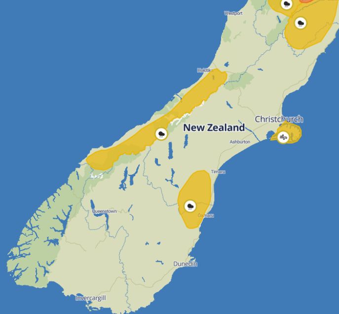
MetService is warning of the potential impacts of a deep sub-tropical low affecting the country today.
It has heavy rain watches in place for the Ranges of the Westland District, from 3pm Thursday through to 3am Saturday, and for North Otago and Canterbury south of Timaru and east of Twizel, from 6pm Thursday through to 6am Friday.
Rainfall amounts may approach warning criteria, MetService says.
On Banks Peninsula, a strong wind watch is in place from 7pm Thursday until 7pm Friday due to northeast winds that may approach severe gale force.
ygf9bfjuhxav8j9b.jpg
"Heavy rain means slippery roads and drivers should think about adjusting their speed and travelling distances, avoiding sudden braking, and staying visible," an NZTA spokesperson said
A red weather warning remains in place for Northland east of Kaikohe from Doubtless Bay to Whangārei, with the worst of the downpours expected to hit on Thursday afternoon.
Marae in the region have been opened for those in need of support, and Fenz has deployed 19 specialist rescue personnel to Northland and Auckland.
As many as 5000 consumers were without power at one stage overnight, but that number had dropped to about 2000 by 4.30am.
MetService said the heaviest rain and largest volumes were likely to be in the upper North Island, from Northland to western Bay of Plenty.
Downpours, flooding, and slips were also possible on Thursday and Friday.
Fenz assistant national commander Ken Cooper warned residents in upper parts of Northland to be ready in case the situation deteriorated.
"For that upper part of Northland, the intelligence we've got is there's a large amount of rainfall over a very short period of time. I would certainly advise people to be prepared, if they're in low lying areas or near rivers, be prepared to move."
Cooper said anyone concerned about a risk to life or property should call 111.
Northland Civil Defence expected the worst of the rain to hit the northeast coast on Thursday night.
In a post on social media, it warned residents not to go into flood water, to avoid unnecessary travel, and to be aware of slips.
"Leave immediately if you notice cracks in the ground, leaning trees or power poles, unusual sounds, or sudden changes in streams," it said.
Whangārei Mayor Ken Couper told Morning Report it had been a wild night with strong winds and consistent but not heavy rain in Waipu, just south of Whangārei.
It was too early to say whether the situation was different up the coast, he said.
"We are concerned because of the weather event that we had in January and the fact we're still recovering from that."
Power was out last night in Oakura, which was affected in the last storm, he said.
All of the 200 slips except for a massive one had been cleared after the January event, he said.
"But there's a number of sites where we were hoping for more time to pass to get things more stable before rain came."
-RNZ and Allied Media


