
Low-lying Balclutha residents have been warned to be ready to evacuate over concerns a breach in a flood bank could flood much of the town.
"There is a risk of flooding from a potential breach of the Hospital Road Detention flood bank in Balclutha," an alert from the Civil Defence said.
"This is not a potential breach of the main Clutha River flood banks."
Residents in low-lying areas in the town should start preparing a grab-bag in case an evacuation is ordered, it said.
"This is a precaution and the exact extent will be advised when more information is available."
People in these areas have been advised to move valuables and furniture to higher parts of their houses.
The Clutha District Council said both it and the ORC were working to reduce the level of water being held by the Hospital Road Detention flood bank.
"Should there be a breach of the Hospital Road detention flood bank the water will flow into areas of the town quite quickly.
"We have been able to reduce the areas of the town potentially affected
"Those properties most likely to be impacted will be visited door-to-door by Civil Defence staff to inform people of the risk and advise them of their options."

Clutha Mayor Bryan Cadogan said the evacuation preparedness warning was "precautionary".
Mr Cadogan told the Otago Daily Times although residents should remain calm, they should prepare to evacuate if they were advised the situation had worsened.
"Our engineers are keeping a watching brief on the situation at present, and have taken steps to reduce the pressure on the area of flood bank concerned.
"I'm told by the technicians the precise flow patterns resulting from any breach would be undetermined, but it would lead to some extent of inundation over a good portion of the flat."
That would include much of central Balclutha, including the main street, he said.
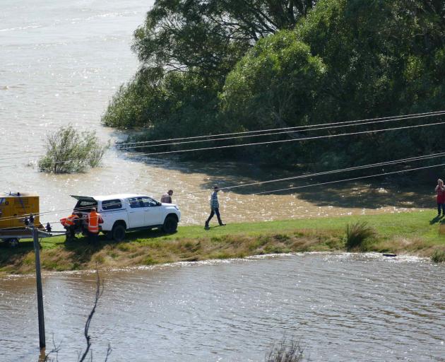
Overseeing the affected flood bank just before noon was City Care Water branch manager Kerrod Baldwin.

He said staff and volunteers were ready to sandbag an "area of seepage" from the flood bank where it adjoined the bottom of Hospital Rd.
His team had closed off a "relief valve" for the retention area on Monday morning, which had now been partially reopened to allow safe emptying of the pond.
Further engineers were pumping stormwater from the pond back into the Clutha River.
Mr Cadogan praised the work of the council's Civil Defence team and contractors during the past 48 hours.
"This has been the most extreme flooding event we've had to deal with in my time, but thanks to everyone's efforts I think the old town will hold together," he said.

Otago Regional Council Duty Flood Officer Pete Stevenson said while rain had mostly moved on from the region, and all weather warnings have been lifted, rivers around Otago were still very high and continuing to rise in some places.
The lower Clutha has risen overnight and is still rising. At Balclutha, it is currently flowing at 3157 cumecs and is expected to peak at up to 3,500 cumecs towards the end of the day.
"This flow is above the peaks seen in November 2018 and December 2019 rainfall events, but well short of the 1999 peak of around 4,200 cumecs.
"The Pomahaka River at Burkes Ford peaked overnight at 874 cumecs, above the February 2011 flood peak of 769 cumecs. The median flow at this site is 15.48 cumecs.

The Clutha District Council have issued an alert to people in low-lying areas of the Balclutha township that there is a risk of flooding from a potential breach of the Hospital Road Detention flood bank. This is not the primary flood bank for the Balclutha township.
As a precaution, the Council is advising people to be prepared in case an evacuation is ordered.
MetService weather warnings around the region have all been lifted. Our estimations for the Southern Lakes have not significantly changed, with Lake Wakatipu and Wanaka both expected to peak short of presenting any significant flood issues.
Last night Mr Cadogan declared a state of emergency.
Waka Kotahi NZ Transport Agency Journey Manager Peter Brown said the Clutha and Mataura [rivers] are expected to peak around midday or early afternoon and until that occurs, the highways surrounding towns like Gore remain closed.
Some motorists hoping to head south are stuck in South Otago.
Clinton woman Jo-anne Thomson, of Food for Thought dairy, said several trucks had been parked in the town overnight.
Some other customers who had come through had returned from Elton John last night and were trying to make their way south, but could not because the roads were closed.
People were being "pretty patient".
Truck drivers had said they thought the roads would be open later today.
Otago travellers planning to drive to Southland are being asked not to start driving south until the state highways have reopened.
Otago Civil Defence Group Controller Richard Saunders said people should stay where they are, rather than heading south and waiting at roadblocks or in towns along the way.
SH1 is closed between Clinton and Gore, as are the alternative routes SH93 Clinton to Mataura and SH90 Tapanui to McNab. SH6 is closed between Frankton and Lumsden. Local roads in all these areas are also affected, and there are no detours.
“With the risk of further flooding in Balclutha, we want to avoid having travellers waiting in the town today. We also ask people to respect “road closed” signs and barriers, which are there for safety.

Intending travellers should check the NZTA website https://www.journeys.nzta.govt.nz/traffic
DCC general manager city services Sandy Graham said, “Now that the city [Dunedin] is returning to normal, we’re able to support our Clutha neighbours who are under a State of Emergency and are experiencing far worse conditions, by providing staff and resources to help them through this difficult time.”
ACCESS TO THE CATLINS
Owaka Highway is closed at Balclutha. We have been operating a detour via Gray Road. Unfortunately damage to this road means that it is closed to all but residents on essential business only. The police are managing this road closure. There is currently NO ROUTE from Balclutha south via the Catlins.
ACCESS TO SOUTHLAND
There is currently no available route from Balclutha to Southland/Invercargill.
STATE HIGHWAYS CLOSED
SH93 Clinton to Mataura CLOSED
SH1 Clinton to Gore CLOSED
SH90 Gore to Tapanui CLOSED
Other Roads
Barnego Rd is closed at the Balclutha Bridge due to water spilling over the flood banks.
The road from Balclutha to Beaumont (Clutha Valley Rd, Clutha River Rd and Rongahere Rd) is Closed
Station Rd (Lovells Flat), Lakeside Rd are now open..


