The future of Lovelock Ave is up for debate again at this year's Dunedin City Council annual plan hearings, where a decision will be made on whether it should make way for the priorities of Dunedin Botanic Garden. Opoho resident Emeritus Professor Helen Leach looks at the avenue's history.
Lovelock Ave is rich in history, though the early portion has only just been revealed.
Most people know that it was named in honour of Jack Lovelock, our Olympic champion at the Berlin Games in 1936.
If you turn up Lovelock Ave from Dundas St, just above the Leith bridge, you will see a commemorative plaque to Lovelock on a boulder just to the right of the road.
Lovelock Ave then climbs through the Town Belt to a sharp corner where a right turn takes you to the entrance to the Northern Cemetery or out to Brackens View.
The avenue continues to the left, following a loop past the Dunedin Botanic Garden azalea garden on the left, and the Opoho Bowling Club and botanic garden education centre on the right.
There are no footpaths on this section of Lovelock Ave because a pedestrian route diverges from the road at the cemetery corner and climbs steeply between Lovelock Bush and the cemetery hedge, rejoining Lovelock Ave where the Opoho sports fields begin.
Jack Lovelock lived in adjacent Warden St while he studied medicine in Dunedin.
Almost certainly he would have trained on both the road and the path beside the cemetery, and it was quite appropriate to rename the road and bush in his honour in 1968.
Before that date, Lovelock Ave was officially Cemetery Rd.
The Dunedin City Council has gained resource consent to close the section of Lovelock Ave above the cemetery corner and to reroute traffic on a new road where the footpath now is - though is to re-examine the issue at its annual plan hearings.
Opoho residents with experience of both routes have protested that the new shorter section would be dangerously icy in winter, prone to sunstrike, and impossibly steep for cyclists.
But the commissioners hearing the resource consent application were not convinced.
The reasons for rerouting Lovelock Ave above the cemetery corner were first revealed to the public on October 18, 2006, at the launch of the Dunedin Botanic Garden strategic development plan.
The closure would improve safety for garden staff and the public and it would improve security by moving vehicles to the outer perimeter of the garden (though the Northern Cemetery, which the road will now flank, has been at least as often targeted by vandals as the Botanic Garden).
Even more importantly, closing upper Lovelock Ave would "unlock an area of prime, flat land, some of the best in the garden", in the words of Jayson Kelly, then president of the Friends of the Botanic Garden. Other reasons emerged in later press releases, including the opportunity to reclaim bush areas (Lovelock Bush) and enhance them.
Significantly, the application for the resource consent began with the statement that Lovelock Ave was an intrusion into the Botanic Garden.
The resource consent hearing was told the realignment "will permit the integration of the entire 28 hectares as a single entity on a site that the Dunedin Botanic Garden has occupied since 1867".
In fact, the road predates the development of the upper garden.
It is not an intrusion.
The botanic garden expanded from 16ha in 1878 until it reached Lovelock Ave, then in the last three decades redrew its northeastern boundary along the edge of the Northern Cemetery.
It now encompasses 28ha.
Long before it was renamed Lovelock Ave, a road joined the lower end of Signal Hill Rd with Dundas St, emerging from the Town Belt at the northern end of Forth St.
It first appears as a track on Fergusson and Mitchell's town map of 1866, but it is probably not accurately positioned.
My attempt to follow its supposed route downhill took me to a very steep, wet hillside below the cemetery corner, quite unsuited to horse- or oxen-drawn vehicles.
However, there was a growing need for a track.
By 1867, Signal Hill Rd had been formed to provide access to the new farms on the ridge and upper slopes.
This track gave the occupiers a quick route to Pelichet Bay and West Harbour.
In 1867, the Botanic Garden was still located on its original site on Leith St.
A year later, it was so badly damaged by a flood that the provincial secretary proposed that it should be relocated to the acclimatisation society's grounds, where the lower garden is now.
In 1869, a competition was held for an appropriate design for the layout of the new site.
The winner proposed cutting walks through an area of bush, presumably on the hillside overlooking the ponds (Otago Daily Times, December 6, 1869).
This marked the start of the expansion of the Botanic Garden up the slope above Lindsays Creek.
Meanwhile, there were plans to take a section of the Town Belt on the other side of the ridge.
By 1864, Dunedin's Southern Cemetery was becoming full.
A Pine Hill landowner offered six or seven acres of his land (at the rather high price of 50 per acre) but the offer was turned down because of its closeness to town, its steepness, and the fact that runoff would flow towards residential areas.
In 1868, a Bill went to Parliament proposing a North Dunedin cemetery on the slope above Pelichet Bay.
Legislation was required because the land would be taken from the Town Belt.
Feelings ran high as William Reynolds told a public meeting that he objected "not only as a representative of the city, but as a citizen, to these reserves or any part of them being taken away from the public".
The Town Belt, he maintained, should not be used "for any purpose save that for which it was intended, the recreation of citizens".
An elector replied that a "neatly-arranged cemetery" was better than a Town Belt damaged by wild animals (Otago Witness, November 14, 1868).
At that time, there was unauthorised removal of timber as well as grazing within the Town Belt.
In 1871, the Private Bills Committee recommended passing the Bill on condition "that the cemetery shall not be within 300 yards of any private residence" (Otago Witness, October 21, 1871).
This was now a relevant issue because the lower flanks of Signal Hill were being subdivided for housing.
The North Dunedin Cemetery Bill was finally passed on August 20, 1872, and by mid-November, the ground had been fenced, plans drawn up for the sexton's lodge, and "the main road to it, from near the Dundas St bridge, has now been completed, and it is expected that the road will be widened and the footpath formed, thus making it a very nice walk for the citizens" (Otago Witness, November 16, 1872).
This road was named Cemetery Rd, and it now forms the lower section of Lovelock Ave.
Within two years, much scrub had been cleared from the cemetery, and a 12ft (3.7m) border laid out around the perimeter.
Its outer edge was planted with a hawthorn hedge.
Today, pedestrians walk beside this hedge on the footpath that will become the new road.
Concern has been expressed that roadworks will damage the root system of what may be the earliest dated hedge in Dunedin, 135 years old.
In 1872, on the other side of the Opoho spur, a gang of prisoners was cutting walks on the slope overlooking the lower garden.
Each pathway was 13ft (4m) wide, with one running beside the riverbank and another around the centre of the slope.
The garden grounds as far as Dundas St were also newly fenced, although no plan exists of the 1872 boundaries.
It was not until 1878, when the Dunedin Botanic Garden was brought under the Public Domains Act (1860) by Order in Council, that we have a legal description.
It was then just over 40 acres (16.2ha) in area.
Though no map accompanied the proclamation in the Government Gazette, the surveyed eastern boundary matches the fence-line appearing in a map of 1880, reproduced in Eric Dunlop's The Story of the Dunedin Botanic Garden (2003, p.49).
This boundary (which also appears on a map dated to around 1905) lies a considerable distance to the west of the current position of upper Lovelock Ave. But when was that section of the road formed?
On the top of the spur, Captain Boyd, the landowner closest to the new cemetery, put up his Estate of Opoho for sale in November 1873.
The plan of the subdivision showed the start of two access routes leading towards the town, one labelled "To Dunedin by Dundas St.", the other curving downhill to the gardens corner.
The first may still have followed the route of the track shown in the 1866 map, though you might expect that once Cemetery Rd was in existence by 1872, traffic would take advantage of that well-graded section.
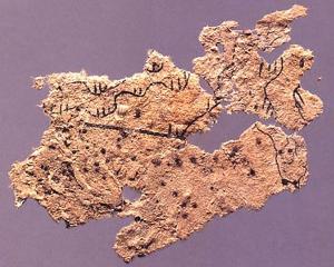
Confirmation of the existence of upper Lovelock Ave in its present position has now been found in a surveyors map dated to 1884 [see illustration].
This map, prepared by registered surveyor Samuel H.
Mirams, accompanied the first attempt of several - all unsuccessful - to expand the North Dunedin Cemetery.
As before, legislation was required since it involved taking more of the Town Belt.
Although expansion would be straightforward on the northeastern side, a formed road (today's upper Lovelock Ave) blocked the cemetery's growth to the southwest.
This resulted in a highly irregular boundary on that side as the surveyor tried to incorporate the block of land now known as Lovelock Bush, right up to the edge of the road loop.
The 1884 Bill made no progress and a Bill with the same title was reintroduced in 1887.
In the Legislative Council, local member James Allen declared that his constituents were opposed because it would take away part of their new playing field (now Opoho Ground) "used for the purposes of football and cricket".
Those supporting the Bill said the extra land to be taken "was nothing but a perfect wilderness" and "a mass of hideous scrub".
Despite some compromise over the size of the extension, the Bill ultimately failed, influenced perhaps by the premier's objection to "devoting public reserves to meeting the necessities of the moment".
Another attempt to extend the cemetery passed in the House of Representatives in 1891.
A petition opposing it was presented on behalf of residents of Opoho, as well as a petition from "31 medical men in Dunedin" who were concerned with the cemetery's drainage into Pelichet Bay.
The Legislative Council threw out the Bill on July 30, 1891.
The opening of a new cemetery at Andersons Bay relieved the pressure on burial space.
As the prospect of an enlarged Northern Cemetery vanished, supporters of the Botanic Garden, such as Apirana Renata (Alfred Reynolds), publicly urged the development of the upper garden.
He wanted to "bring these gardens of beautiful and vast capabilities into a final state of order, from Woodhaugh to the Northern Cemetery" (Otago Witness, October 26, 1893).
This desire for an eastward expansion was to be put into practice following the appointment of a new superintendent, Kew-trained David Tannock, in 1902.
The need for a new bridge over the Leith saw a fresh piece of legislation passed on behalf of the Dunedin City Council in 1902.
Once again, the Town Belt was involved.
Clause 4 of the Dunedin Town Belt Roads Closing and Regulation Act (1902) gave the city power to make or alter roads through the Town Belt by special order of council.
However, if it proceeded to close a road, it had to provide the citizens with "an equally convenient substitute".
To protect the Botanic Garden, clause 5 declared it unlawful for the city council to make a road through the Botanic Garden.
It is ironic that the 1902 Act gives no protection to upper Lovelock Ave today, even though maps now show the land on both sides of the road to be part of the 28ha of the Botanic Garden.
However, in 1902 the road was bordered by the Town Belt, and that designation was effectively frozen in law.
As superintendent, David Tannock had the additional responsibility of managing the Town Belt.
In 1903, he reported to the city council that he wanted to extend the garden into the Town Belt at various points along the ridge.
One such extension was for a nursery, and later ones were for the rhododendron dell (1914) and the azalea garden (1922).
The eastern boundary fence erected in 1872 was still marked on town maps but in the light of the garden extensions into the Town Belt, Tannock requested funding for a new perimeter fence along the upper edge of Cemetery Rd and over the ridge to Opoho Rd.
This did not eventuate.
By 1970, garden staff members saw the native bush (now Lovelock Bush) and arboretum extension on the east of upper Lovelock Ave as under their stewardship.
It became increasingly irritating to have a public road running through it.
The Visitor Education Centre, completed in 1982, was the first garden facility to be built on the eastern side of the road.
Soon after, the Orchiston flax collection was planted beside it, and a native wetland garden with boardwalk.
By 1990, the Botanic Garden had expanded right up to the cemetery hedge.
Vandalism has always been a problem in public gardens and, in the 1980s, unfenced Lovelock Ave was seen as an easy point of night-time access to Brackens View, the Northern Cemetery and the upper Botanic Garden.
Council staff believed that much of the damage was done with vehicles so the best option would be to exclude all vehicles in the hours of darkness.
A trial closure period of six months was approved by the council on August 4, 1986, and gates were installed at both ends of Lovelock Ave.
Opoho residents, many of whom protested that they would have to drive a longer route to get home, were asked to set aside their rights as individuals "in the interests of protecting the city's resource".
Most Opoho residents, and even the mayor, Cliff Skeggs, were unhappy with the idea of punishing the general public for the behaviour of vandals, but the council by majority vote closed the road from October 1, 1986, using the same Dunedin Town Belt Roads Act of 1902 that had stipulated that citizens were to be provided with an equally convenient substitute.
No-one seems to have noticed that when travelling from Logan Park, Opoho Rd is a poor substitute for Lovelock Ave.
Closure inconvenienced the lives of Opoho residents for 13 months and only a public campaign led by Barbara Calvert brought it to an end.
If the avenue is finally rerouted, the DCC will provide a substitute route at a cost of about $1 million.
However, many citizens remain concerned about the potential traffic hazards posed by a steep (1 in 6.2 gradient) south-facing road.
Others are sad they will lose a scenic drive beside the upper garden, or a peaceful traffic-free walk beside the cemetery.
Cyclists deplore the loss of their well-graded uphill route from Dundas St to Opoho.
The patch of hillside has proved as controversial in the 21st century as it was in the 1880s and 1980s.
Anzac Ave is to be realigned as part of the construction of the Forsyth Barr Stadium.
Motorists heading out along Highway 88 to Port Chalmers will leave Anzac Ave at an elevated roundabout and proceed along a new road about 200m east of Anzac Ave.
They will cross the Leith on a new bridge and get an unimpeded view of the stadium.
Unlike many street names, Anzac Ave is related to two historical events, one that led to its construction, and the other that it commemorates through its name.
The 1925-6 New Zealand and South Seas Exhibition, an international showcase for New Zealand which was attended by more than three million people, was held on the newly reclaimed Logan Park.
A railway line had been put through to the site by 1924 to carry construction materials, but it was felt that a ceremonial avenue should link the venue with Dunedin Railway Station.
When completed, the avenue began at Anzac Square, at the bottom of Stuart St, and finished at the exhibition.
In 1925, crowds attended the Anzac Day memorial service held in the exhibition building.
Naming the avenue in honour of fallen comrades was entirely appropriate.
Although the name will still apply to the southern end, and presumably to the bus park and concourse that will replace the northern section, in future motorists will enjoy the shade of the magnificent trees of the avenue for only one block before entering the new Highway 88.