State Highway 6 between Makarora and Franz Josef has closed for the night as the West Coast waits on more major rainfall.
The highway closed from 9pm Wednesday and will not reopen until 10am Thursday at the earliest.
Slips and surface flooding are expected along the route.
The wild weather has also brought down power poles near Haast, and some customers could be without power for several days.
A boil water notice has been issued for Franz Josef township.
SH 6 between Fox Glacier and Franz Josef reopened for a period from 3pm.
The road was closed from Haast to Franz Josef for most of the morning owing to two major slips, but in an update shortly before midday NZ Transport Agency Waka Kotahi advised that one of the slips, south of Bruce Bay, had been cleared and the highway was open there under traffic control.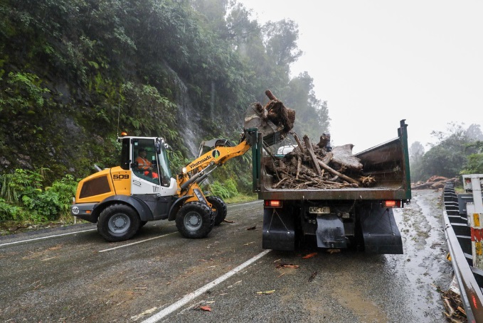
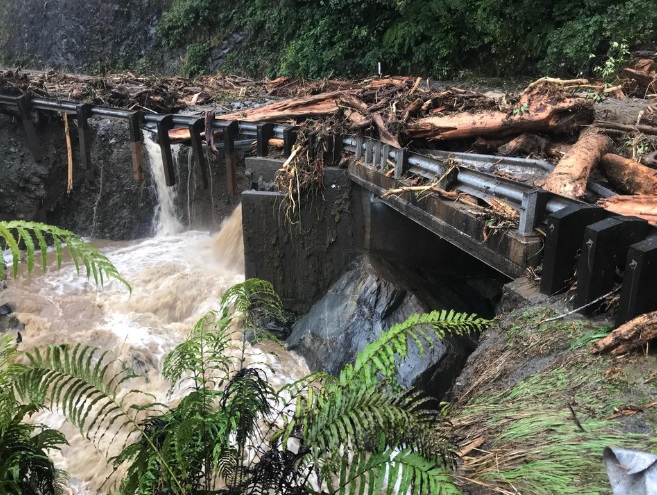
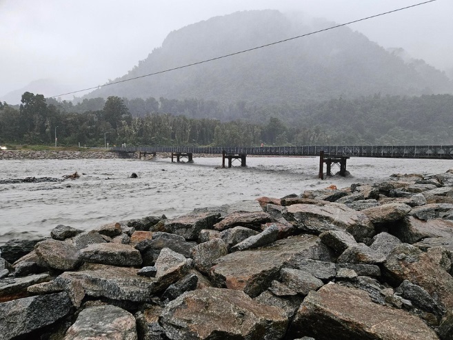
In Franz Josef, close to 300mm of rain had fallen since yesterday, West Coast Emergency Management (WCEM) group controller Te Aroha Cook said this morning, and the Waiho River had reached peak levels.
Orange warning remains
About midday emergency management officials said they were keeping the rain warning for Westland at a "high orange" for the next 12-18 hours.
They earlier said it was likely it would be upgraded to red today.
Cook told Midday Report officials would assess the weather warning levels later this afternoon.
"The greatest area for concern is in terms of the tributaries and catchments for our South Westland areas but primarily Franz Josef and the Waiau, with the high intensities of rain which has been 366 mm to date," she said.
"Even though we've got a lull in the weather at the moment if we have higher intensities, it's how those tributaries will cope with the higher levels of water already in them."
Cook said there were fears of more flooding but no-one had been forced to evacuate yet.
"In the event that there's any failure of infrastructure or inundation we're prepared to respond and meet people's needs accordingly."
She said there were power outages in Haast, Jacksons and Hannahs Clearing.
Fire and Emergency NZ has sent in additional resources to help with the situation.
Six Canterbury firefighters were yesterday deployed to Franz Josef and today they were shifted to Fox Glacier.
Response coordinator Brian Keown said they had a four-wheel drive and were able to provide support to the local community and local fire brigades.
Additionally Fire and Emergency deployed 15 specialist team members to Franz Josef.
"Eight are members of the Specialist Water Response Team and they will be available for any activities involving water, including rescues. The other seven are members of Fire and Emergency's Urban Search and Rescue (USAR) team. Their primary task will be rapid damage assessments, but they are also trained and equipped for search and rescue," Keown said.
'Just a heavy fall of rain'
Richard Molloy has lived in the Waiho Flats, next to the Waiho River, for 20 years.
He says they have dealt with flooding before, but rain is part of life on the West Coast.
Molloy says he is prepared with food and firewood, and there are robust stopbanks along the river.
"The hype that goes on with forecasts now - an atmospheric river? It used to be a downpour, and now it's an atmospheric river," he says.
"They dream up all these new fancy things to dramatise the situation. It's just a heavy fall of rain."
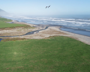
The Otago Regional Council has asked people to treat all waterways with caution during the deluge.
Council manager science Tom Dyer said although major flooding is not expected people should remain cautious.
"While we do not expect significant flooding, people should treat all waterways with caution.
"If they live or work close to a river or area which regularly floods they should take any usual precautions, such as monitoring stock and check ORC’s river monitoring site," he said.
Power poles down
Three power poles are down due to sea conditions, affecting customers south of Hannahs Clearing, near Haast.
"The outage could result in several days without power," WCEM said.
"The slips are hindering our capability to access and provide fault repairs to Haast.
"We are currently investigating contractors from Cromwell to assist where possible."
Short-lived reprieve
Westland Mayor Helen Lash earlier this morning said they were getting a reprieve from the rain at the moment.
"Rivers, I'm talking multiple, they've bobbed around, they've come in and out of being on that (first) alarm level, which is good it hasn't got any further than that.
"Everything is very very wet, I know in Franz Joef they probably had in excess of 150ml, 170ml overnight. And I know that's been through right up to Hokitika, I think it was about 120ml overnight up in the ranges."
However, Lash said they expected "significant levels of rain" to return tonight.
And preparations were under way in case an evacuation centre needed to be established, and sandbags were available in Hokitika where flooding in the CBD was possible, she said.
"We've seen over the last 24 hours about 200mm to 250mm in those ranges. Just for context, we would typically issue an orange warning for rainfall of 100mm in a 24-hour period."
She told Morning Report a "brief easing" was expected in rainfall today along the West Coast as that front sank southwards.
"That doesn't last for too long. Into Thursday we're expecting that heavy rain to ramp up."
Weather warnings
MetService has issued its latest weather warnings, saying parts of the North Island were in for heavy rain and northerly gales as the front hovering over Westland made its way northwards later this week.
The full list of watches and warnings, as at 10am on Wednesday:
Orange heavy rain warning
Mount Taranaki: 6pm Thursday - 9am Friday
Tasman northwest of Motueka: 6am Thursday - 3am Friday
Buller District south of Seddonville and northwest of Reefton: 6am - midnight Thursday
Westland District south of Hokitika: 9am Wednesday - 9pm Thursday
Headwaters of Canterbury Lakes and Rivers south of Arthur's Pass: 9am Wednesday - 6pm Thursday
Headwaters of Otago Lakes and Rivers: 11am Wednesday - 6pm Thursday
Fiordland: 1pm Wednesday - 6pm Thursday
Southland: 6am - midnight Thursday
The Bryant Range, also inland Marlborough west of Blenheim and north of the Awatere River: 9am Thursday - 6am Friday
Heavy rain watch
Northland: 6pm Thursday - 6am Friday
Nelson Lakes, Buller District about and southeast of Reefton, Grey District, and Westland District about and north of Hokitika: 3am Thursday - 3am Friday
Clutha: 6am Thursday - 2am Friday
Strong wind watch
Taranaki south of the Mountain, Taihape and the Whanganui Hill Country: 3pm Thursday - 6am Friday
Buller District, Nelson/Tasman and Marlborough: Midday Thursday - 3am Friday
Wellington: 6pm Thursday - 6am Friday
Canterbury High Country: Midnight Wednesday - 6pm Thursday
"The high tide is what makes the issues for us. The tide turns it up."
He told Morning Report the surrounding homes were built away from flood-prone areas.
Cameron says preparations for the weather started yesterday and all his cattle have been moved.
He says the Waiho River is becoming more of a problem.
"That river has filled up a lot and it's an ongoing issue for that community."
MetService said a front was expected to move slowly between Westland and Fiordland over today and into tomorrow, before heading north.
The forecaster says a humid northerly flow will precede the front, bringing periods of heavy rain to Fiordland and Westland, strong winds to Fiordland and the Canterbury High Country, and large waves to the West Coast.
- additional reporting ODT Online