
Motorists are being warned to be wary of icy roads today following a frigid southerly blast which closed major highways and schools across much of the South yesterday.
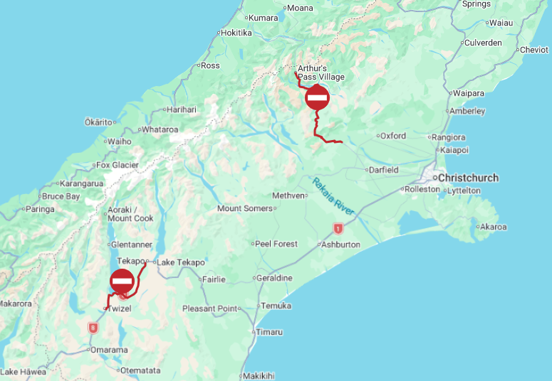
Parts of State Highway 73 between Christchurch and the West Coast, and State Highway 8 in the Mackenzie Basin, are closed due to snow and ice.

A spokesman for the NZ Transport Agency/Waka Kotahi said contractors were working to make the road safe again for truck and trailer units to be moved and carry on their journeys.
SH 8 between Lake Tekapo and Twizel is also closed. A detour route is available via State Highways 8, 1, 82 and 83.
NZTA also has multiple area warnings in place across other central South Island state highways because of the ice risk and winter driving conditions. People were urged to take extra care if travelling on these inland roads.

In Queenstown, frost and ice remains a risk, particularly in sheltered spots. A spokeswoman for the Queenstown Lakes District Council advised there was also a build-up of loose grit on the roads following yesterday’s snow event, and people should drive with caution.
Frost and ice is on the Crown Range and Cardrona Valley, and in the Queenstown and Whakatipu Basin areas in shaded spots.
Road snowfall warning
Lewis Pass (SH7)
Snow lowering to about 500 metres early on Friday morning. Expect 1cm to 3cm of snow to accumulate on the road above 500 metres about and east of the summit during the day.
Serious crash closes part of SH6
SH6/Taramakau Highway north of Kumara Junction on the West Coast is under traffic management following a serious crash this morning that earlier closed the road.
In a statement, police said they were notified of the crash involving one vehicle just north of the intersection about 5.30am today.
"Initial indications are that there are serious injuries."
Road users were advised to take extra care when travelling along this route and to follow directions provided at the site.

Frosty weekend for many
MetService meteorologist Michael Pawley said heavy snow, hail and rain fell over much of inland Otago and Southland yesterday, and today much of that moisture would turn to ice as temperatures dropped below zero.
‘‘It’s looking frosty for many, many areas through to the weekend and into early next week.
‘‘You could even see some severe frosts as far south as Invercargill, with temperatures dropping to -5˚C in some places.
‘‘And the ground can be up to 4˚C below that. So it will be pretty icy, I’d say.’’
He urged motorists to be wary of ice on southern roads for the next few days, at least.
‘‘Even though this low moves off and the severe weather weakens, it’s still going to stay southerly for quite a while, so that’ll keep the air pretty cold - especially for the South Island.
‘‘I don’t think we have a warmer northwesterly building for a little while.’’
Yesterday’s polar blast closed Arrowtown and Poolburn primary schools for the day, and nine inbound and outbound flights at Queenstown Airport were cancelled due to freezing fog.
Heavy snow and ice also stranded some vehicles and closed the Crown Range Road between Queenstown and Wānaka, State Highway 8 (the Lindis Pass) between Omarama and Tarras, Danseys Pass and SH85 between Lauder and Wedderburn.
Black ice and snow also prompted local councils to advise caution when driving in the Ida Valley, Naseby, Becks, St Bathans, the Kawarau Gorge (SH6), Milford Rd (SH94), Wānaka to Haast (SH6), Ranfurly to Omakau (SH85), Centre Hill (SH94) and Parawa (SH6).

Ski fields happy
Despite the disruption, skifields in the Queenstown area were rejoicing.
NZSki chief executive Paul Anderson said at least 15cm of snow had fallen on both The Remarkables and Coronet Peak ski areas, blanketing Coronet Peak and enabling at least the learners’ areas at The Remarkables to open tomorrow.
Staff were working hard to get a chairlift operating at Coronet Peak tomorrow, and a decision about whether The Remarkables could do the same would be made once the storm cleared.
‘‘Our problem today is you literally can’t see - there’s so much snow up there blowing around.’’
Mr Anderson said snowguns were working at both ski areas and would continue for about 36 hours, which would be perfectly timed for the New South Wales school holidaymakers who would be part of the first wave to arrive in Queenstown tomorrow.
While the weather was looking more settled next week, more snow looked likely to arrive next weekend, just in time for the beginning of the New Zealand school holidays, he said.
‘‘We’re hoping that because it [the snow] has come late, it’ll just keep coming.’’


