
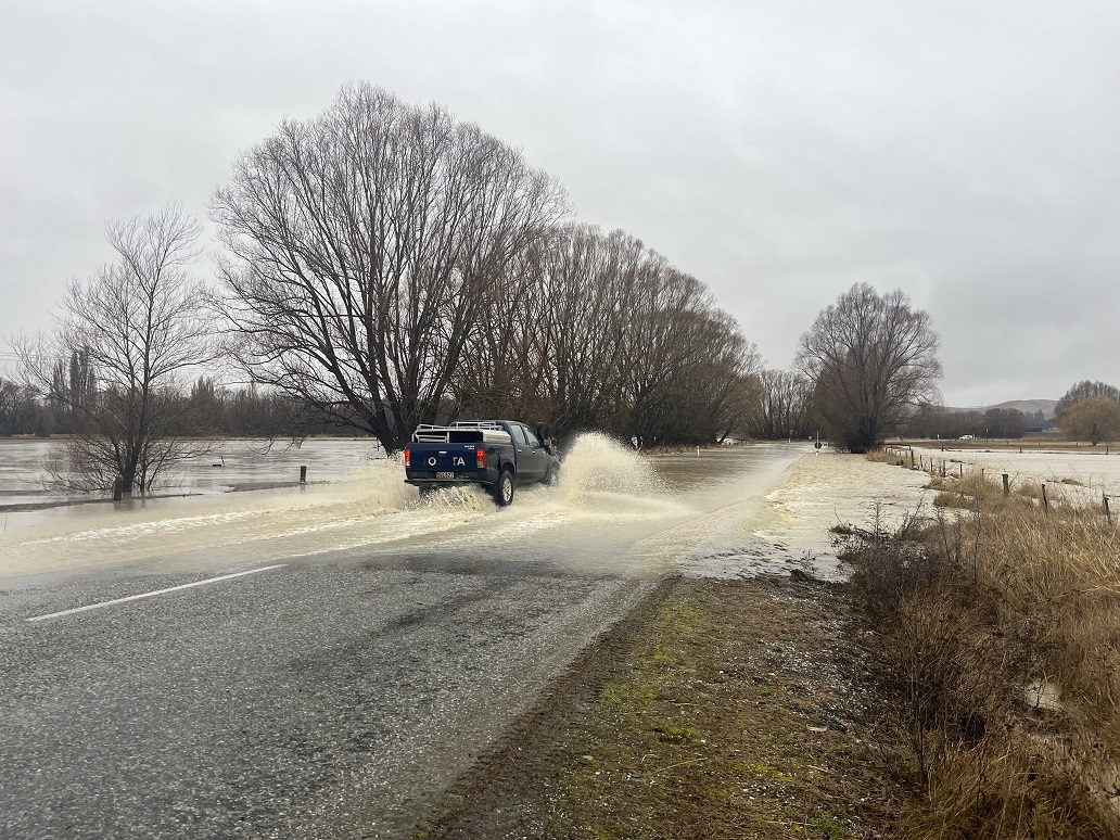
A massive clean-up is ahead for parts of Canterbury after a storm flooded homes and farms, ripped up roads, cut off towns and sliced a bridge in half.
Many roads were still closed this morning owing to slips or flooding. But as river levels and flood waters drop people are waiting to see the full extent of the damage.
The Ashburton River broke its banks and flooded some farmland last night, as heavy rain swelled most rivers in the region.
Canterbury Civil Defence Emergency Management was monitoring key rivers this morning and warned the impact of the rainfall would be seen overnight and today.
MetService forecaster Gerard Bellam said the south had "seen the worst" of the rain and today it would ease to light rain.
However, a low was deepening to the east and by tomorrow southerlies would bring cold temperatures.
Coastal areas would feel the worst of the effects and there could be large swells, he said.
The Lindis Pass (State Highway 8), between Tarras and Omarama, remained closed overnight and this morning with fresh snow falling and several areas of slips and flooding, says Waka Kotahi NZ Transport Agency.
SH6 (Haast Pass) SH83 Omarama to Otematata were also closed.
There are speed restrictions in place on some stretches of highway, and closures on a raft of minor roads in the Maniototo area (scroll to bottom of story to see closures).
Environment Canterbury said Meridian Energy has started spilling water into the Lower Waitaki River, and flows will increase to around 1000-1200 cumecs over the coming days. Landowners adjacent to this river should continue to monitor their own situation as some out of river flows could occur across farmland at these elevated flows.
Flows have peaked and are dropping in the Ahuriri River, Twizel River, Omarama Stream, and Otematata River. The Opihi River has peaked at Rockwood in the upper reaches, but is still rising in the lower reaches. Flows are expected to be contained within the stopbanks. However, ECan is monitoring the river in the Milford Huts area.
The Orari River peaked around 440 cumecs at the gorge but will still be rising in the lower reaches. A spokesperson said ECan staff have been monitoring the river below the gorge, and some out of river flows could occur across farmland.
The Rangitata River peaked at 4pm yesterday at the gorge at 1120 cumecs. Peak flows will take a few hours to travel from the gorge to the mouth, so the river will be flowing high into today. Overflows into the South Branch are unlikely, but ECan staff are continuing to monitor the river in this area.
The Ashburton River South Branch, North Branch, Taylors Stream, and Bowyers Stream have now all peaked and are dropping in the upper reaches. The main stem is still rising at SH1, but is expected to peak at around 800 cumecs last night. Staff have been monitoring river conditions today, with overflows into farmland in some places.
Rhys Roberts has farms south of the river in Mount Somers and Westerfield and said both parts of both properties were underwater.
He said the next few days would be assessing the scale of the damage.
"One of the farms is a dairy farm that's got cows calving down in the next five days," he said.
"For us it's quite important to get that farm back up on its feet so there'll be a lot of effort go into this farm.
"We're hoping it hasn't caused much scouring but we'll be re-assessing that."
ECan rivers manager Leigh Griffiths told Morning Report the Ashburton River floodbanks had all been fixed before the flood.
However she said there was some erosion, partly because the vegetation hadn't had time to establish.
"There's still a huge amount of work to do on the river, we've done a lot."
Gravel extraction work had started since the floods last year but said it will cost millions of dollars to remove it all.
The gravel sits quite high up in the catchment and a lot of contractors didn't want to go that far up to remove it because of the transport costs, she said.
"Some of the issue with Ashburton is that the stopbanks are far too close to the river, it's a historic issue which we're trying to sort out so we're actively talking to central government and others about how we can get some funding to relocate stopbanks a bit further back from the river to give the river a bit more room to move."
The Rakaia River peaked at about 2600 cumecs last night at Fighting Hill, and no significant out of river flooding is anticipated. The Waimakariri River has peaked at about 1000 cumecs at Otarama, and this flow will be easily contained by the stopbanks. Both rivers continued to rise in their lower reaches last night and flows will remain high into today.
The Selwyn River peaked at about 32 cumecs at Whitecliffs and is now dropping. No out of river flooding issues are anticipated in the Selwyn catchment.
In Omarama, dozens of people had to flee the Top 10 Holiday Park and owner Irwin Beiboer said many of the units were still underwater.
"There's too much water flowing through there (to check the remaining units)," he said.
"We think some units have been hit the hardest because they're standing at the lowest place.
"The units we have checked, the carpet is soggy, the showers, the toilets, everything is just muddy and wet."
Further south in Otematata, where several homes were flooded, locals are calling the storm the biggest in nearly half a century,
Volunteer firefighter Richard Jopson said water was still flowing down some streets last night despite the rain easing.
"There's still a bit of water around," he said.
"We evacuated about three homes to be fair and those people are happy now.
"We'll just continue the cleanup [today] and see what the day brings."
The only bridge into Lake Ōhau, near Twizel, has been washed out leaving more than 100 holidaymakers at the local lodge stranded.
Fixing it is a top priority for Waitaki District Council.
"It's a bit of a problem and we can't really get onto it until the waters receed," Waitaki mayor Gary Kircher said.
Kircher is working out how to make sure people stranded on one side the bridge don't run out of the essentials.
"They're okay for the time being but it is just a matter of making sure they've got food supplies and all the bits that they need to look after the people that are in there," he said.
"We're still working on the logistics around making sure those people are properly looked after."
The Waitaki River usually runs at 300-400 cumecs and is currently running at 1500 cumecs, he said.
"There's a heck of a lot of water running down to the coast. The ground, everything is just so sodden - that's caused a lot of the slips, a lot of the blockages on the roads."
Mount Cook Village has also been cut off after being hammered in the storm.
More than 400mm of rain fell in 24 hours at the village.
A big slip closed SH80 leaving local man Charlie Hobbs unable to get home yesterday.
"I'm hoping they'll be able to shift that debris which is about 80 to 100 metres wide covering the road," he said.
Waka Kotahi expected to be able to tell people by midday when the road will re-open.
Timaru Civil Defence is monitoring river levels which remain high but are beginning to recede.
Heavy rainfall inland east of the Southern Alps that resulted in high river flows are still affecting some roads and low-lying areas.
A council spokesperson said river levels are dropping but some remain high.
Road closures will affect travel in some areas and people should check their route before leaving.
Further south, heavy rain was also seen at the Upper Clutha River catchments and in the headwaters of Central Otago rivers, including the Kawarau River, the Shotover River, the Lindis River, the Manuherikia River and the Kye Burn/upper Taieri River.
The Queenstown Lakes District Council this morning advised of "a lot of water on the road between Wānaka and Cromwell, near Pisa, and you can expect this elsewhere on your journeys". The council said motorists were likely to encounter debris on roads through the region.
Further south, the Gore District Council says the Mataura River has risen significantly overnight, and several roads are closed around the city. The river was expected to start dropping soon, and roads could reopen later this morning.
The Otago Regional Council was yesterday urging people to be cautious around rivers and low-lying land as waterways around Central Otago and the upper Clutha catchments rise.
Waka Kotahi NZ Transport Agency is warning drivers in Otago and Canterbury to be aware of slips and possible washouts on a number of routes.
Otago and Southland system manager Graeme Hall said slips and rockfalls would continue this week.
Haast Pass was closed owing to fallen trees, rock slips, flooding and strong winds.
An Aspiring Highways representative said a "couple of diggers had been sent to clear the road and assessments were being done between Makarora and Hawea."
Makarora resident Jim Arthurs said yesterday weather over the past 48 hours had varied.
"We had a huge thunderstorm last night. A lot of internet routers fried, and lots of new lakes are forming on farms," he said.
The Haast-Hawea section of SH6 was open to Makarora residents yesterday, but closed to the general public from 7am.
Updates on the Haast and Lindis Passes are expected this morning.
Last night, SH8 through Alexandra was the only route open to SH1 for northbound travel out of Central Otago.
The downpour caused roads and walking tracks to close as the Manuherikia River breached its banks near Omakau, Ophir and Galloway, flooding low-lying farmland.
A boil water notice was issued for Omakau and Ophir, and Ophir residents were advised to keep a sharp watch on river levels.
The highest previous flow recorded for the Manuherikia River at Ophir, since 1971, was 602 cumecs in December 1995.
Otago Regional Council natural hazards manager Dr Jean-Luc Payan said the Manuherikia River at Ophir reached its peak about 4pm yesterday and, while high, had begun to fall.
The main rivers in Southland were all running above normal and there were reports of localised flooding.
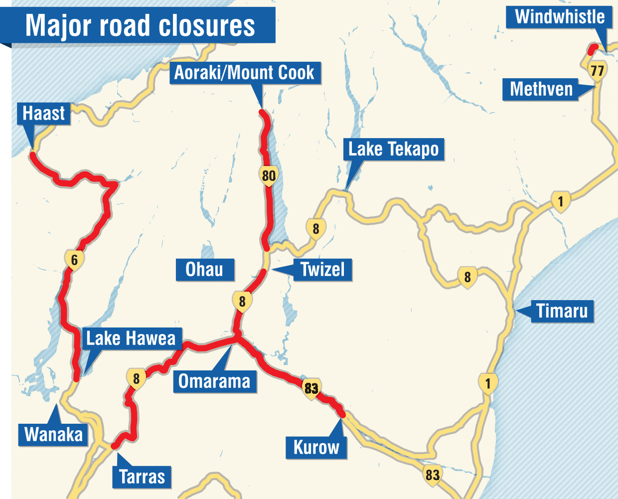
Road closure/cautions
CLOSED
• SH6 Haast to Lake Hawea - Fallen trees - next update midday Wed 20 Jul
• SH6 Murchison - Flooding - between the intersections of SH65 and Hinehaka Rd next update middy Wed 20 Jul
• SH8 Twizel to Tarras - Flooding - next update midday Wed 20 Jul
• SH77 Mt Hutt between Blackford Rd and Mt Hutt Station Rd - Washout - next update midday Thu 21 Jul
• SH80 Ben Ohau to Aoraki Mount Cook - Slip - next update midday Wed 20 Jul
• SH83 Omarama and Otematata - Flooding - next update midday Wed 20 Jul
OPEN CAUTION
• SH1 Picton to Ward – Strong Winds
• SH6 Mount Pisa to Cromwell – Flooding
• SH6 Arrowtown Junction to Cromwell (Kawarau Gorge)
• SH6 Kingston to Lumsden - Surface Flooding
• SH6 Lowther to Lumsden, at the Lowther Road intersection - Surface Flooding
• SH8 Fairlie to Lake Tekapo - Flooding
• SH73 Springfield to Arthur's Pass - Strong Winds
• SH77 Windwhistle to Ashburton - Flooding
• SH79 Fairlie to Geraldine - Strong winds
• SH83 Otematata to Pukeuri - Flooding
• SH97 Lowther to Mossburn, at the Lowther Road intersection - Surface Flooding
OPEN
• SH94 Te Anau to Milford
• All other State Highways remain open


