PHOTO

The tsunami evacuation zones on Banks Peninsula have been updated based on new scientific research.
New computer modelling has provided Christchurch City Council with the updated information about areas that could flood if a tsunami hit the Canterbury coastline.
"The latest modelling shows us that in most areas, flooding from a tsunami may extend further inland than allowed for under the previous tsunami evacuation zones," said Rob Orchard, council's head of civil defence emergency management.
"If you live or own property on Banks Peninsula, I would encourage you to go onto our website and check whether your property has been affected by the tsunami evacuation zone changes."
The website has a search function that allows you to enter a property’s address to see which tsunami evacuation zone it is in.
"If you are in a tsunami evacuation zone, it is important that you have an evacuation plan for your household," Orchard said.
"You need to think about the route you would take to evacuate and where you would go."
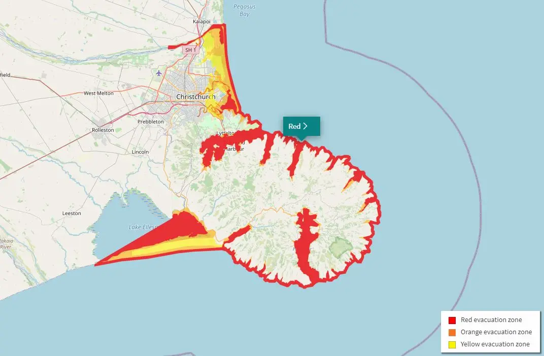
On most of Banks Peninsula, there are two tsunami evacuation zones - a red zone and an orange zone. In Birdlings Flat there are three - red, orange and yellow.
The red tsunami evacuation zone is most likely to be affected by a tsunami. It includes estuaries, rivers, beaches and harbours, where a tsunami of any size could cause strong currents and surges in the water.
The orange tsunami evacuation zone covers areas on land that could be flooded in the event of a large tsunami.
"If you’re in the red or orange zones and feel a rolling-motion earthquake for longer than a minute or a strong earthquake that makes it hard to stand up, you need to leave the area.
"When the shaking stops, head immediately to the nearest high ground or as far inland as you can, out of the red and orange zones," Orchard said.
The yellow tsunami evacuation zone is least likely to be affected by tsunami, but could be flooded or isolated in a very large tsunami.
"If you are in the yellow zone, you only need to leave the area if you receive an official warning from Civil Defence Emergency Management.
"These warnings will be given through an emergency mobile alert to your phone, on radio, television and social media," Orchard said.
Drop-in sessions where you can talk to council staff about the new evacuation zones will be held on:
- Sunday, November 29: 9.00am - noon, the Little River Community Breakfast, Banks Peninsula Rugby Club Rooms, Awa-iti Domain, Little River.
- Tuesday, December 1: 3.30pm - 7.30pm, Allendale Hall, Allandale Reserve, 122/154 Governors Bay Teddington Rd, Allandale.
- Thursday, December 3: 2.30pm - 6pm, The Gaiety Akaroa, Rue Jolie, Akaroa.
Find out more about the evacuation zones here.
