
Scores of flights have been cancelled and power is out to thousands across the country as forecast wild winds lash the country.
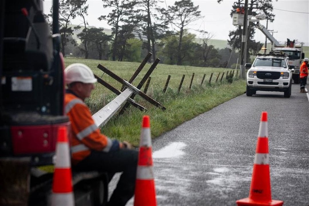
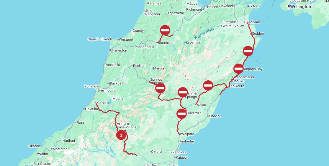
There are widespread highway closures across the South Island owing to slips, fallen trees and surface flooding.
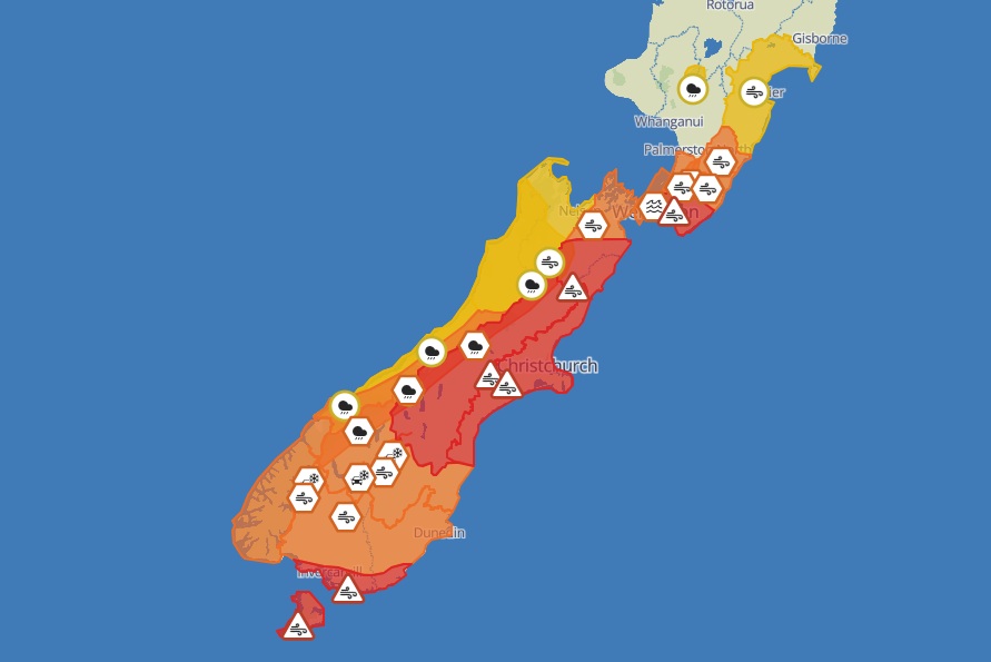
MetService has a raft of severe weather alerts in place, including red strong wind warnings for parts of the South, and further north in Canterbury and Marlborough.
The forecaster said a "huge" wind gust of 230km/h was recorded on Pudding Hill in the Marlborough region earlier today.
The weather station now appears to be offline.
Duty forecaster Silvia Martino said Mount Cook Aerodrome had a 156km/h gust, and Invercargill Airport has been buffeted by gusts of up to 137km/h.
Fie and Emergency New Zealand (Fenz) said they responded to 264 weather-related callouts between 7.40am and 1pm, predominantly for roofs lifting and trees down.
There were also callouts for fences down, sheds blown away, a loose satellite dish on a roof and loose trampolines.
Wellington and Canterbury saw the most callouts in the early morning before Southland was hit hardest at lunchtime, with 139 callouts between 11.55am and 1pm.
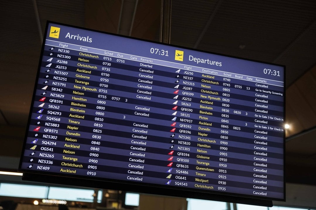
Flights cancelled
The weather led to most flights being cancelled at the airports in Dunedin, Queenstown and Invercargill, and the cancellations were continuing into the afternoon.
Christchurch Airport this afternoon said it was open and operating, "but the strong winds are causing flight cancellations, disruptions and delays".
The airport's website showed most flights as either delayed or cancelled.
Air New Zealand said it was is offering flexibility to passengers travelling through Wellington, Christchurch or Dunedin today as the severe weather moved across the country.
The airline said travellers booked on flights between 6am and 6pm could change their bookings free of charge to any time within 48 hours of their original flight. Changes can be made directly through the Air NZ app.
A massive power outage hit the upper South Island this morning, cutting electricity to about 90,000 households, but most customers had it restored by late morning.
However, Transpower advised that there could be ongoing outages throughout the day.
Many businesses were forced to close due to the outage and some were operating cash only.
Transpower's executive general manager, Mark Ryall, earlier told Nine to Noon there were three big transmission circuits for the upper South Island which had all tripped.
Nelson City Council said the power outage included Nelson, Hanmer, Greymouth and Blenheim.
"Transpower crews are working to restore power. Traffic lights are out across the region, and motorists are being urged to drive with extra care."
Shortly before 10am the council said power was being restored throughout the city.
As power was being restored further north, more than 1600 people in the Hanmer Springs area were without supply around 11am.
The Hurunui District Council said trees had fallen across a powerline and multiple roads.
MainPower's website says it's aware of the outages and is working to restore supply.
Power is also out to thousands of customers in parts of the North Island.
At 2.55pm, Powerco's website showed nearly 5000 customers without power.
Gusts of more than 200kmh were recorded overnight in exposed areas of the Canterbury High Country, and more strong winds are expected to hit the wider region and lower North Island today.
MetService head of weather news Heather Keats said pretty much all of the eastern side of the country would get strong winds today.
'Threat to life'
Keats told Morning Report today's destructive weather would impact all of the South Island and most of the lower North Island.
She said the warnings should not be ignored and there was a threat to life.
"It's set to ramp up from now and only going to get worse."
Keats said the weather system was fast moving so it should improve later today, but more bad weather would return on Monday.
Despite the bad weather, there would be unusual heat, with Hastings reaching 30 degrees Celsius.
"This spring has been relentless," Keats said.
"It does feel like it has been system after system after system."
Keats said the stronger winds this week were more than MetService would usually expect to see in spring.
Raft of warnings
MetService has today updated its severe weather alerts after warning of "potentially destructive and damaging winds" across southern regions today.
The forecaster was advising residents to "stay indoors or seek sturdy shelter away from trees".
MetService meteorologist Mmathapelo Makgabutlane said Otago, Southland and Canterbury had already had "one big windy system" this week, but this one was expected to be more intense.
She said the severe gales were caused by a deep low-pressure system to the south of New Zealand, and a high-pressure system to the northeast of New Zealand.
"That difference in pressure between the low-pressure and the high-pressure systems will be really intensifying the winds, especially because they’re in such close proximity, and that low is quite low — possibly lower than 960 hectopascals.
State of emergency
Emergency Management and Recovery Minister Mark Mitchell yesterday declared a state of emergency for Canterbury, which was expected to bear the brunt of the weather.
"I have made this declaration as the Canterbury mayors have not yet been able to be sworn in following the recent local elections," Mr Mitchell said.
"The National Emergency Management Agency have been in close contact with the Canterbury Civil Defence Emergency Management Group and confirmed that a declaration is necessary.
"The state of local emergency will ensure local Civil Defence have access to the emergency powers they need to respond and support emergency services during this event."
Those in red warning areas could expect severe gale northwesterlies with damaging gusts of up to 150kmh in exposed places.
A heavy rain warning for the headwaters of the Otago lakes and rivers was due to lapse at midday.
john.lewis@odt.co.nz/additional reporting RNZ/ODT Online


