PHOTO
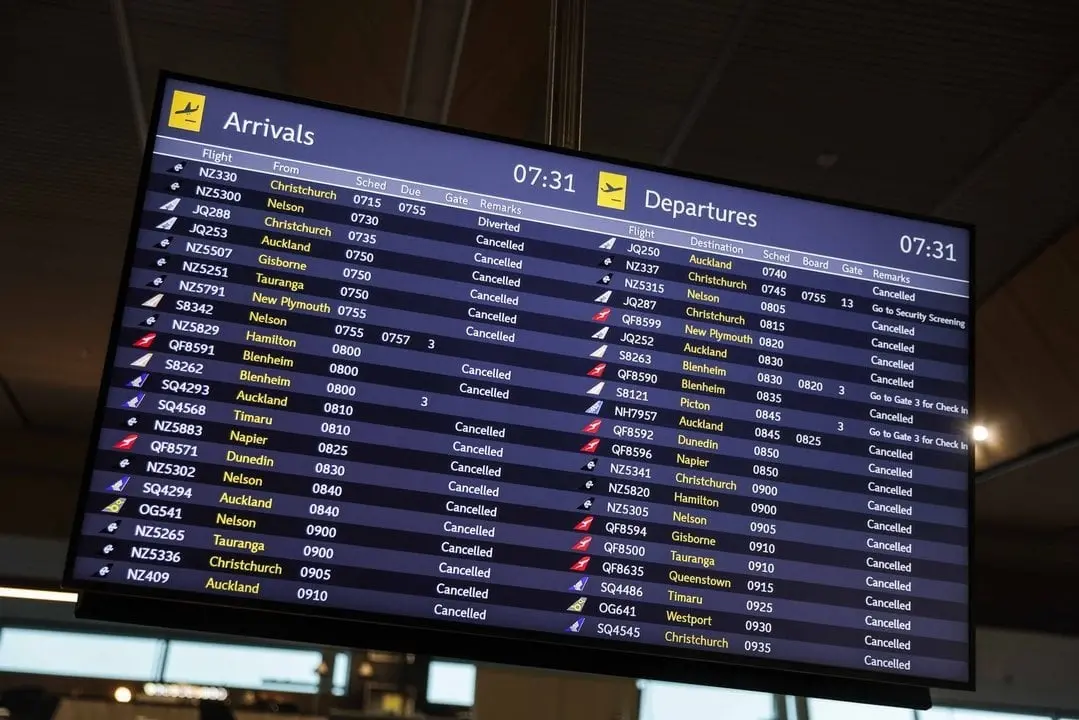
Scores of flights have been cancelled across the country as forecast wild winds start lashing many areas.
Gusts of more than 200kmh have been recorded in exposed areas of the Canterbury High Country already, as strong winds are expected to hit the wider region and lower North Island today.
A red wind warning is in place in Wellington, Christchurch, wider Canterbury and Marlborough from Cape Campbell southwards.
MetService head of weather news Heather Keats says pretty much all of the eastern side of the country will get strong winds today.
At Christchurch Airport at least 55 cancellations are listed on its website, while Air New Zealand has cancelled all flights out of Wellington Airport this morning, after its website earlier showed 67 cancellations.
Dunedin Airport's website shows a slew of cancellations this morning.
Many flights in and out of Queenstown Airport have also been cancelled.
Air New Zealand is offering flexibility to passengers travelling through Wellington, Christchurch or Dunedin today as severe weather moves across the country.
The airline said travellers booked on flights between 6am and 6pm could change their bookings free of charge to any time within 48 hours of their original flight. Changes can be made directly through the Air NZ app.
Several highways are closed in both main islands, owing to surface flooding, slips and trees coming down.
Shortly before 8am there were reports of a massive power outage in Nelson.
Nelson City Council said traffic lights were down across the city.
Transpower confirmed the outage and said teams were looking into it.
The council said there were reports the outage was widespread through Tasman too.
'Threat to life'
Keats from MetService told Morning Report today's destructive weather would impact all of the South Island and most of the lower North Island.
She said the warnings should not be ignored and there was a threat to life.
"It's set to ramp up from now and only going to get worse."
Keats said the weather system was fast moving so it should improve later today, but more bad weather would return on Monday.
Despite the bad weather, there would be unusual heat, with Hastings reaching 30 degrees Celsius.
"This spring has been relentless," Keats said.
"It does feel like it has been system after system after system."
Keats said the stronger winds this week were more than MetService would usually expect to see in spring.
Raft of warnings
MetService late last night issued warnings for "potentially destructive and damaging winds" across southern regions today.
The forecaster is advising residents to "stay indoors or seek sturdy shelter away from trees".
MetService meteorologist Mmathapelo Makgabutlane said Otago, Southland and Canterbury had already had "one big windy system" this week, but this one was expected to be more intense.
She said the severe gales were caused by a deep low-pressure system to the south of New Zealand, and a high-pressure system to the northeast of New Zealand.
"That difference in pressure between the low-pressure and the high-pressure systems will be really intensifying the winds, especially because they’re in such close proximity, and that low is quite low — possibly lower than 960 hectopascals.
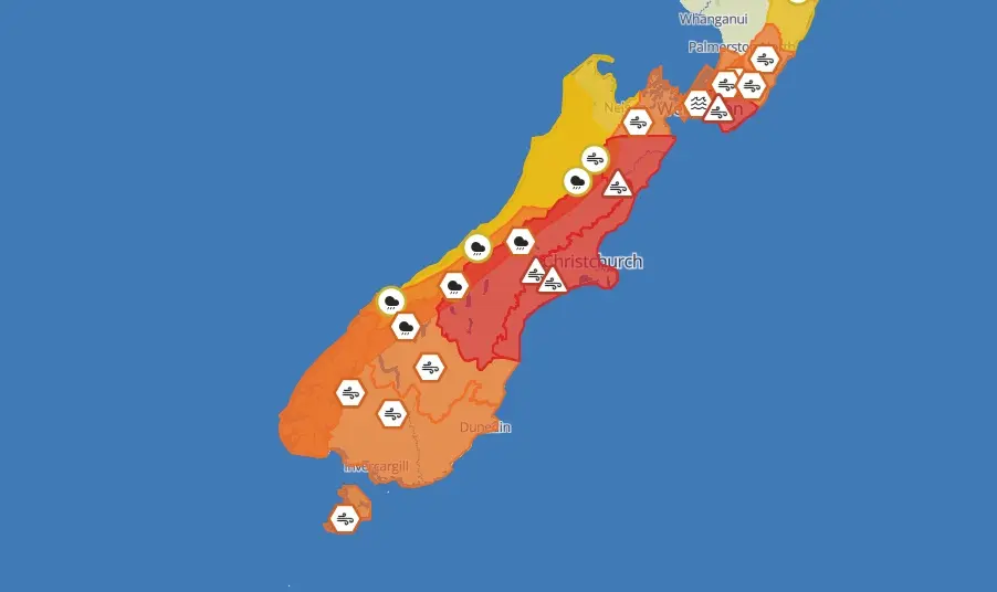
MetService has issued a red warning for strong winds in the Canterbury High Country from 1am to 5pm today, and Emergency Management and Recovery Minister Mark Mitchell yesterday declared a state of emergency in the region.
"I have made this declaration as the Canterbury mayors have not yet been able to be sworn in following the recent local elections," Mr Mitchell said.
"The National Emergency Management Agency have been in close contact with the Canterbury Civil Defence Emergency Management Group and confirmed that a declaration is necessary.
"The state of local emergency will ensure local Civil Defence have access to the emergency powers they need to respond and support emergency services during this event."
Orange wind warnings have also been issued for Otago, Southland and Stewart Island from 3am to 3pm today, but Mrs Makgabutlane said those could also be upgraded to red, and urged residents to keep a close eye on the MetService website.
Those in red warning areas could expect severe gale northwesterlies with damaging gusts of up to 150kmh in exposed places.
She said there would be threat to life from flying items and falling trees, and destructive winds would cause widespread damage, including powerlines and roofs.
It would also create dangerous driving conditions and significant disruption to transport and power supplies, so she urged people to stay indoors or seek sturdy shelter away from trees, and avoid travel.
"Also be ready for power and communication outages.
"If you still have power, charge your phones now in case the power goes out."
Those in orange warning areas could get wind gusts up to 130kmh. She said people should avoid driving high-sided vehicles or motorcycles.
In Otago (excluding Clutha), the severe gale northwesterlies could be upgraded to a red warning, she said.
"These winds have the potential to be very destructive and damaging."
In Clutha, Southland and Stewart Island, the severe gale northwesterlies were expected to change about noon today to severe gale west-to-southwesterlies gusting to 130kmh in exposed places, especially near the coast.
This could also be upgraded to a red warning, she said.
The forecast for tomorrow is for showers in the west and south, with possible thunderstorms for coastal Southland and Fiordland, but it will be mainly fine elsewhere.
john.lewis@odt.co.nz/additional reporting RNZ