Conditions have eased in the South after a morning of wild winds and heavy rain kicked off a "volatile" week of weather for much of the country.
High winds caused significant disruptions around Dunedin today, with flights delayed or cancelled, and trees and branches down across the city, causing power outages, and a large shed collapsing at a timber yard in Mosgiel. No one was in the building at the time.
Other parts of the South also got a battering, with high winds in Southland and snow affecting alpine passes the Milford Road (State Highway 94) and the Crown Range Road.
MetService said the first of two major systems expected to hit this week arrived today and would continue on Tuesday, but a more powerful system would occur on Thursday and Friday.
Forecaster Mmathapelo Makgabutlane said both would bring heavy rain and very gusty winds to the South Island and lower half of the North Island.
"Tuesday's event is big - but Thursday's could be more intense and more widespread."
Though winds had eased by mid-afternoon on Monday, MetService's head of weather news Heather Keats said it was shaping as a "fairly volatile looking weather week".
Just before 5pm today, strong wind watches were issued for Otago, Clutha, Fiordland and Southland including Stewart Island, Christchurch and the Canterbury Plains, where west to northwest winds may approach severe gale in exposed places from between 7am and 7pm on Tuesday.
This could cause more damage to trees, powerlines, unsecured structures, as well as dangerous driving conditions - particularly for motorbikes and high-sided vehicles.
Meanwhile, a heavy rain watch was in place for the Southern Lakes, Mackenzie Basin and Canterbury High Country more than 30km east of the divide and south of State Highway 73, from 8pm today until 3am on Tuesday.
Periods of heavy rain were likely and amounts may approach warning criteria. The rain was expected to ease from the south on Tuesday morning.
Thursday 'big day for South'
An "even more impactful weather system" was expected to arrive on Thursday into Friday, Keats said, and there would be more warnings issued closer to the time.
"The potential is there for this to be a highly impactful event. Gale northwesterlies tied in with a very significant front and a deep low pressure system to the far south of the country which will bring cold southwesterlies.
"Thursday will be a big day in the South and for central New Zealand."
Keats said the country was experiencing was typical spring weather. Because there was little reprieve between the fast-moving fronts, it was feeling like a "very active" spring.
"Yes, it will calm down, but it doesn't look likely this week and maybe even to next week as we see again those fast fronts as they cross over us."

Trees down in Dunedin
High winds caused significant disruptions around Dunedin today, with flights delayed or cancelled, and trees and branches down across the city.
Fire and Emergency New Zealand (Fenz) this morning warned motorists to take care while driving on Dunedin roads and units had responded to multiple incidents of tree falls.
They included two trees blown over in Anzac Ave (State Highway 88) - one fracturing a water main, resulting in part of the road being closed.
In an update about 3.50pm, the NZ Transport Agency/Waka Kotahi said a tree had been cleared and the northbound lane of Anzac Avenue between Frederick St and Harrow St was open.
However, the southbound lane remained shut as the damaged water main was assessed by CityCare Water staff. A detour was available via Ward St.
People earlier reported that a tree down on Three Mile Hill Rd, at the Halfway Bush end, was completely blocking the road.
The Fenz spokesman urged motorists to take extra care when driving and secure anything that was loose in their vehicles.
He also said any planned burn-offs in the area should be delayed and to check on any that were already going.
Further north, a truck's trailer was blown on to its side near Tekapo, closing SH8 for a time. The road had reopened by 2.45pm.
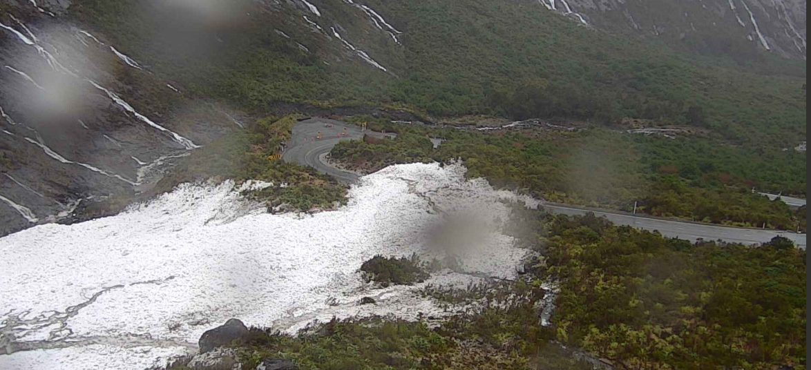 The Milford Road (SH94) in Southland has closed and will reopen on Tuesday after avalanche debris has been cleared. PHOTO: MILFORD ROAD ALLIANCE
Snow affecting alpine passes
The Milford Road (SH94) in Southland has closed and will reopen on Tuesday after avalanche debris has been cleared. PHOTO: MILFORD ROAD ALLIANCE
Snow affecting alpine passes
In Southland, the Milford Road is closed for the day due to heavy rain increasing the avalanche hazard.
MetService said Milford Sound received 36mm of rain in an hour this morning.
A road snowfall warning had been issued for SH94, with up to 15cm of snow expected from Tuesday into Wednesday.
More closures were likely during the week, the Milford Road Alliance advised.
"Overnight closure expected at 5pm on Tuesday for snow. Reopening on Wednesday when snow clearing allows. An all-day closure on Thursday is probable with another large volatile weather system forecast which will increase the avalanche hazard."
Snow had also been falling on the Crown Range, linking Queenstown and Wānaka, from about midday, prompting warnings for drivers to carry chains.
Transport disrupted, power cut
Air New Zealand chief operating officer Alex Marren said high winds affected some South Island services this morning.
Five flights in and out of Dunedin and two in and out of Invercargill were cancelled.
The airline said it was monitoring conditions closely. For customers travelling today, it recommended keeping an eye on the Air New Zealand app for the latest information on their flight.
Meanwhile, some ferry services elsewhere in the country had been cancelled due to rough weather.
Power was out in several areas for a time, including parts of Mosgiel, Pine Hill and Woodhaugh in Dunedin, and in Roxburgh East in Central Otago.
Aurora Energy reported that about 700 customers in Mosgiel and nearly 200 customers in Dunedin were out of power because vegetation had fallen on a line during the high winds. Power had been restored to most customers by mid-afternoon.
In Stedman Rd, Mosgiel, a shed at Young Bro’s Posts timber yard collapsed due to strong winds. It was reported to emergency services about 10.30am.
A Young Bro’s spokesman said there was no one inside the shed when it collapsed. Everyone was far away in another section of the worksite and WorkSafe had been notified. The shed would be demolished, he said.
Fire and Emergency NZ shift manager Simon Lyford said crews had been called out to multiple reports of roofing iron being lifted or blown around near Invercargill and Riverton.
In Tihaka, a Riverton fire crew helped to secure a sheet that had come off a roof and flown across the road about 7am, he said.
Rain, flooding threat
The Queenstown Lakes District Council said heavy rain was expected to fall throughout Monday and warned of possible flooding across the district.
It urged people to take care on roads and to keep an eye on its social media posts for updates.
On the West Coast, communities were being urged to prepare as an active front moved in.
Forecasters earlier warned up to 300mm of rain could to hit the Westland ranges near the glaciers between 9am today and 6am on Tuesday, and by 5pm today said it was possible 200mm could still arrive on top of what had already fallen.
West Coast Emergency Management manager Claire Brown says people should get ready, as the rain is expected to continue into Tuesday.
"We're keeping a very close eye on the river levels across the Westland District. At this point we don't have any immediate cause for concern, but we'll obviously have eyes on that overnight as well."
People camping or travelling across the region should take extra care as getting caught out in an exposed area overnight could be dangerous, she said.
Further north, Tasman District council said heavy rainfall could cause some of the region's rivers to flood, including the Motueka area which is still recovering from June/July's floods.
The council said there was "potential for high flood flows to eventuate" in the upper Motueka river area including the Wangapeka/Tadmor/Motupiko rivers. Low flood levels were expected for Aorere, Tākaka and Buller rivers.
"Rain will build overnight with the heaviest falls around dawn on Tuesday. This will lead to flood peaks in the upper Motueka area through the early afternoon, with lower Motueka peaks likely late afternoon/early evening," the council said in a post on Facebook.
The council said it was likely that flows in that area would be the highest seen since the large winter floods, but they were not expected to be anywhere near that extent
- Allied Media and RNZ