

The good news is, Earth Sciences New Zealand is predicting the southern regions may be set for some more prolonged settled periods of weather over the next three months, compared with our recent summer.
Earth Sciences New Zealand forecasting principal scientist Chris Brandolino is urging southerners to make the most of the autumn weather, after giving a rare extended insight into the winter ahead for the South, which is shaping up to be very cold in 2026.
Mr Brandolino said weather patterns transitioned to El Nino Southern Oscillation-neutral (Enso-neutral) during February, which meant neither La Nina nor El Nino patterns would be in effect.
Enso-neutral conditions in New Zealand define a period where ocean temperatures, rainfall and winds across the tropical Pacific Ocean and New Zealand are near their long-term average.
Unlike El Nino (which brings more westerly winds and drier eastern conditions) or La Nina (which brings more northeasterly winds and wetter northern conditions), a neutral state meant no single major climate driver was dominating, he said.
"There is a 95% chance for Enso-neutral conditions to remain in the tropical Pacific over the forecast period [March to May]."
For the next three-month period, the atmospheric circulation pattern over New Zealand was expected to bring anomalous high pressure to the south of the country.
"Southern Ocean weather systems may be reduced in frequency, and the South Island in particular could see some prolonged settled periods."
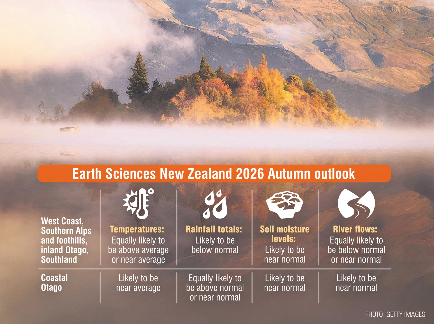
On the West Coast and in the Southern Alps and foothills, inland Otago and Southland, temperatures were about equally likely to be above average or near average, and rainfall totals were most likely to be below normal during autumn, he said.
Soil moisture levels were most likely to be near normal, and river flows were equally likely to be below normal or near normal.
Along coastal Otago, temperatures were most likely to be near average, rainfall totals were about equally likely to be above normal or near normal and soil moisture levels and river flows were most likely to be near normal.
Mr Brandolino urged residents to make the most of the settled weather.
He said it was looking "increasingly likely" El Nino conditions would arrive in New Zealand for the start of winter.
El Nino typically brings colder, more frequent southerly winds to New Zealand during winter, often causing sharper cold snaps and increased frost risks, particularly in eastern regions.
While it can lead to drier conditions in the east, it may also increase the likelihood of heavy snow or winter storms due to stronger, colder airflows.


