Snow has been settling in Dunedin and many parts of the South as a cold blast moves up the country.
MetService this morning updated its advisories to include a heavy snow warning for Southland, Stewart Island, Clutha, Dunedin, Central Otago south of Alexandra, the Southern Lakes District south of Queenstown, and Fiordland from Te Anau southwards.
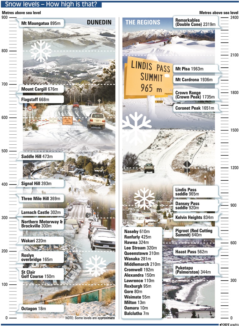
The forecaster said these areas could expect 20 to 30cm of snow above about 200m, with lesser amounts down to sea level.
By early afternoon, snow was falling to sea level intermittently in Dunedin, with bursts of hail as well as blue sky at times.
Waka Kotahi/NZ Transport Agency advised at 6.15pm today that State Highway 87 (Kyeburn to Outram) was closed due to snow.
More snow showers were forecast to affect Dunedin's Northern Motorway (SH1) from 8pm today until 6pm tomorrow, with up to 10cm expected over this period.
A heavy snow watch was in place for North Otago, Central Otago from Alexandra northwards, and the Southern Lakes District from Queenstown northwards.
The Queenstown Lakes District Council said this afternoon it was expecting the brunt of the storm to come through from about 8pm until early tomorrow morning.
"There is a reasonably high chance of road closures, between the snow fall and expected low temperatures. We will have patrols out, but our roading crews recommend delaying any non-essential travel, particularly in darkness."
Reports of heavy flurries came in from around Otago and Southland throughout the day, and snow has settled in some places including the Maniototo and Manuherikia areas. The Danseys Pass road is closed.
MetService meteorologist Angus Hines earlier said a "bitterly cold polar outbreak" was expected to bring a return to wintry conditions from today as cold air from the Antarctic moves up the South Island.
The cold weather was expected to continue into tomorrow, before turning mostly fine by Friday, although temperatures will remain low over the weekend.
Such an early-October cold snap was uncommon and there was potential for record low temperatures, Mr Hines said.
In Invercargill, today’s maximum temperature was forecast to be 6degC, while the lowest previous October temperature was 5.8degC, he said.
Road snow warnings
Road snow warnings are in place for Dunedin’s Northern Motorway (State Highway 1), the Milford Rd (SH94), the Crown Range Rd (linking Queenstown and Wanaka) and some of South Island’s alpine passes.
More snow showers were likely to continue to affect the Dunedin road from 8pm today until 6pm tomorrow, with between 6cm and 10cm of snow forecast.
State Highway 8 (Kyeburn to Outram) closed at 6.15pm today due to snow and Waka Kotahi/ NZ Transport Agency advised that an alternative route should be used.
Snow closed the Lindis Pass (SH8) for a time this morning, but shortly after 10am it had reopened. Snow flurries may affect the road at times between 8pm today and 12pm tomorrow, with a further 2cm on top of what had already fallen expected.
Waka Kotahi said caution was needed between Raes Junction and Alexandra, as well as SH85, due to snow from early this afternoon.
The Queenstown Lakes District Council said there had been flurries all over the district this morning and snow had been cleared either side of the Crown Range. Chains need to be carried.
More snow flurries were forecast for the road from 8pm today until 9pm tomorrow, with a further 1cm to 2cm of snow expected.
QLDC said snow was falling reasonably heavy on SH6 from Cromwell through to Kingston late this afternoon, but all roads were passable at this stage.
In Southland, snow flurries were expected to affect the Milford Road (SH94) from 8pm today until 9pm on Thursday. Another 2cm to 4cm could settle, mainly south of Lake Gunn from the morning.
Snow was also expected to affect the Lewis Pass (SH7) with a further 3cm forecast.
Meanwhile, snow warnings were lifted for Porters Pass (SH73), Arthur's Pass (SH73) and Haast Pass (SH6) tonight.
Southern district road policing manager Inspector James Ure urged people to drive to the conditions by increasing following distances and allowing extra time.
Waka Kotahi journey manager Tresca Forrester said drivers should monitor weather forecasts and pack warm clothes and food if they were travelling.
Extra care was also needed for driving high-sided vehicles or campervans due to expected high winds, Ms Forrester said.
MetService said winds of 83km/h had been recorded in Moeraki and 76km/h in Invercargill today.

Eye on crops and animals
Cromwell fruitgrower Simon Webb said dealing with the cold snap was different from the inversion frosts which often affected orchards.
Because it was cold air, frost-fighting wind machines would not work as well as systems which worked by sprinkling water over fruit, which most orchardists did not have.
For those orchardists, "if it’s blowing and it goes below zero, there’s nothing you can do," Mr Webb said.
The worst-case scenario for affected areas was that vulnerable fruit could be killed off and orchardists would have to wait another 15 months for the next crop, Mr Webb said.
Central Otago high country farmer Andrew Paterson said he had been getting recently shorn stock into sheltered paddocks, along with ewes and lambs that were being shepherded.
Other high country stock would have to find their own shelter, as it would do more damage moving them once they had started lambing, Mr Paterson said.
This morning, Mr Paterson told RNZ he woke up to land covered in an inch of snow.
"We normally get a snow dump in the first week of October, so we try to time lambing around that, but that can be hard.
"The lambing on the flat is well into it, so the snow hasn't come at the best time, the team have been around to check on everything as much as they can, they're just looking over the fences with binoculars to see if there's any issues."
A cold south-west wind forecast for later today would cause more issues for the lambs than the snow, but in the meantime a few hours of sun would help ewes and lambs, he said.

Local govt voting
Dunedin deputy electoral officer Clare Sullivan did not expect major disruption of voting.
An NZ Post spokesman said any voting papers received by councils by noon on Saturday would be deemed to be eligible.
Any ballots not delivered to councils or the two election counting organisations, Election Services and Electionz.com, due to weather would be invalid.
If a council required extra time due to weather, the electoral organisations could decide to make an application to extend the voting period, he said.
oscar.francis@odt.co.nz/additional reporting ODT Online/RNZ