
It lifted tiles on some roofs, downed trees and brought down power lines on Thursday night.
Power was cut to hundreds of homes.
Council clean crews were out on Friday morning assessing the damage.
Hamilton Civil Defence controller Kelvin Powell said it was a rough night for the city.
"I've seen some CCTV footage of nearby... there were very extreme heavy winds, the rain was coming in on almost a horizontal angle and it was similar to the feedback from members of the communities."
But reports from Fire and Emergency suggested the damage was limited, he said.
Powell confirmed the power outage for 75 homes was caused by a flying trampoline that hit a power junction box creating a "small explosion".
One picture on social media shows a trampoline wedged high up in power lines.
"It seems to come from nowhere and taken everyone by surprised, and would have been quite frightening for our community," Powell said.
He added that Hamilton was not under a weather warning when the weather hit.
"We were able to get support people in there straight away, and we will be going back in this morning to have a review and see what support additionally that the community might require," he said.
"It's a very resilient community and people tend to look after each other."
Civil Defence have not yet received any reports of flooding or people needing emergency housing as a result of the weather.
Hamilton's mayor Paula Southgate said emergency services and arborists responded to clean up and repair damage.
She last night urged people to stay away from the area.
Neighbourhood Support has urged the same, suggesting people should check on their neighbours.
For a time, 100 homes in Nawton and another 300 in Bader were without power.
Power was cut to nearly 100 homes at about 9.30pm, but has since been restored. A further 300 homes in and around the southern suburb of Bader lost power at midnight but this was restored within an hour and a half. Early on Friday more than 170 properties remained disconnected.
MetService could not confirm the tornado.
It said there would be lingering showers as the thunderstorms moved eastwards.
Emergency services in Hamilton attended more than a dozen weather related calls overnight.
Fire and Emergency were also called to trees blown down in Clevedon and Mangatangi, south of Auckland.
High winds have been battering the region.
Earlier on Thursday two homes in the city lost roof tiles and some trees were downed in the suburb of Dinsdale.
One business had minor flooding.
Severe thunderstorm warnings for Kaipara, Far North, Whangārei and Rodney issued earlier in the day by MetService had since been lifted.
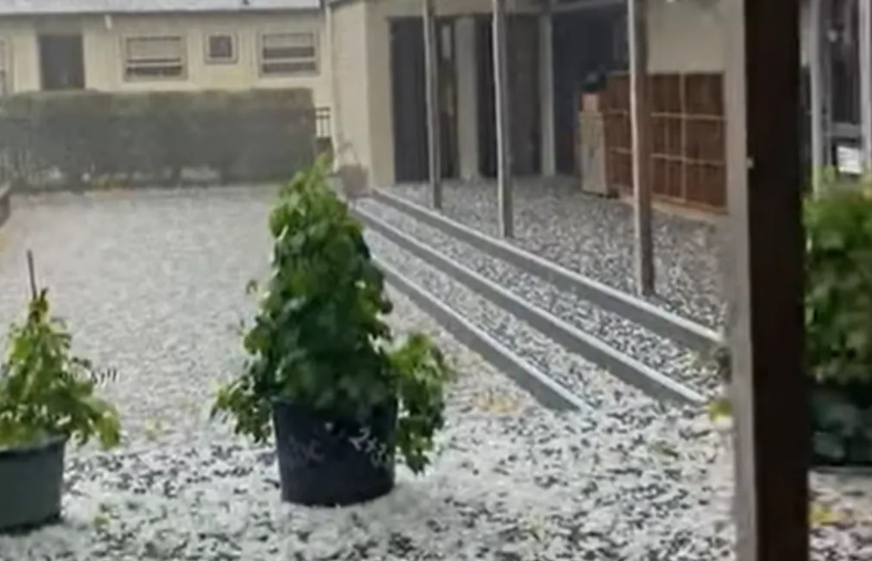
Elsewhere, Waipā District Council said a sudden hailstorm may have caused surface flooding in some areas.
St Peter's Catholic School in Cambridge posted a video of the aftermath to its social media account.
A Cambridge resident also posted "scary hail storm ... never seen anything like it" on social media.
A low was moving eastward across the North Island, bringing possible severe gales, MetService said.
It said there was also a low risk of a small tornado, which could occur with or without a thunderstorm.
MetService said during Friday and over the weekend, a strong west to southwest flow would affect the country.
Watches for the possibility of severe gales were in place for several areas, including Hawke's Bay, Southern Fiordland, Southland, Stewart Island, Clutha and Dunedin. There was a high chance these watches would be upgraded to wind warnings.
A strong wind watch was also in place for Chatham Islands with a moderate chance of an upgrade.
"Damage to trees, powerlines, and unsecured structures [are] possible. Driving may be difficult, especially for high-sided vehicles and motorcycles," MetService said.
The forecasting agency advised residents in these areas to secure items that could be picked up by strong winds and drive cautiously.
Meanwhile, road snowfall warnings were in place for three roads in Southland and Central Otago.
Lindis Pass (SH8), Crown Range Road and Milford Road (SH94) were expected to have snow accumulate on Friday.
In Bay of Plenty, State Highway 25 north of Thames was closed due to a slip early on Thursday.
The New Zealand Transport Agency (NZTA) said the highway would remain closed while it awaited a technical evaluation and there was no detour available. It said motorists should avoid the area.
Lanes on State Highway 2 near Ōpōtiki were also blocked due to multiple slips on Waioweka Gorge. Motorists can still travel on this route, however, they are advised to take care.
NZTA's System Manager for Waikato Andy Oakley said it knew the state highway needed increased resilience and this was a focus for the agency.
Weekend weather
Fortunately, the wild weather is likely to clear up just in time for the weekend.
During Friday and Saturday a strong west to southwest flow affects the country, MetService said.
"We will still have the hangover from the current low pressure system that's moving across the country. So, strong southwesterlies persist through to Saturday," MetService's Heather Keats said.
A ridge of high pressure over the North Island until Monday will calm the weather, with clear skies for most of the weekend, she said.
However, there will be some showers in the south and west of the South Island.


