
By 10pm yesterday MetService had recorded almost 3500 lightning strikes over the day. Many of these were on the West Coast - 1120 in Westland - while the Southern Alps blocked most of them making it over to the east coast.
Two Air New Zealand flights were diverted to Christchurch after being struck by lightning yesterday on their way to Queenstown.
Flights to Dunedin were affected by strong winds; at least one was cancelled and others disrupted, and passengers on some flights reported lengthy periods of turbulence.
The stormy weather has ushered in cold conditions in the South. This morning there was snow on the ground in places around Otago including near Lawrence and on the Crown Range road. There was also a dusting on Flagstaff and Mt Cargill in Dunedin.
Ice and snow forced the closure of the Milford road (State Highway 94) for a time this morning. The NZ Transport Agency said it had reopened around 10am.
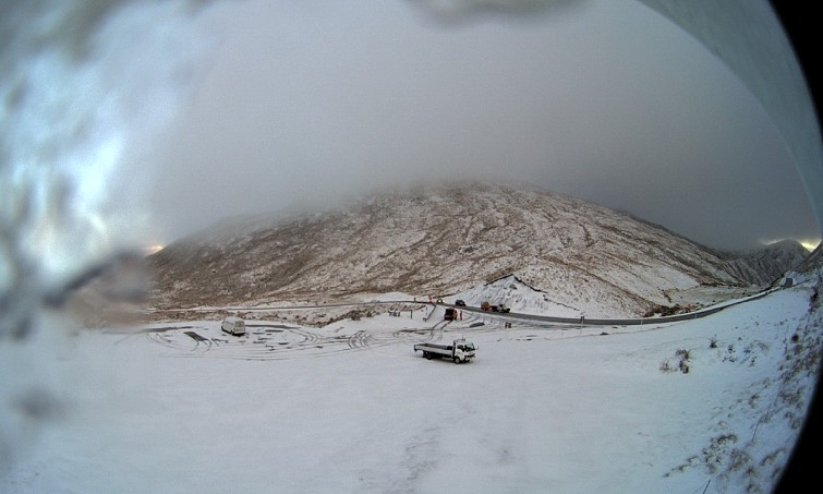
The Queenstown Lakes District Council advised of snow on the Crown Range road, saying chains must be carried, and there was a black ice caution advisory for SH8, Omarama-Tarras (Lindis Pass).
The weakening front behind all of the severe weather was slowly making its way up the North Island today, MetService meteorologist Stephen Glassey said.
The severe weather was due to ease through the day with just some showers forecast in western areas.
Auckland will see a few showers and a high of 19C. Wellington is in for a mostly fine day with northwesterlies and a high of 16C. Canterbury is slightly cooler with southwesterlies and a high of 13C forecast.
The far south is feeling the brunt of the wintry storms, with Invercargill and Queenstown both struggling to make it past 8C.
Due to the icy southwest winds this was likely to feel even colder, Glassey said.
The weather generally improves moving further east with Tauranga in for some fine spells and a high of 19C, while the east coast looks the pick of the bunch with Napier forecast a fine day with a high of 20C.
Winds reached gale force yesterday about Wairarapa, Wellington, Marlborough and most exposed places in the South Island.
Wellington's suburb of Kelburn recorded a gust of 110kmh while Le Bons Bay on Banks Peninsula near Christchurch got up to 140kmh.
Dunedin Airport recorded a gust of 110kmh.
The heaviest rain was in Arthur's Pass where 113mm fell in the past 24 hours. Milford Sound was a close second with 112mm.
MetService had issued road snow warnings for many of the South Island's alpine passes.
Through to 11am Lewis Pass (SH7), Arthur's Pass (SH73) and Lindis Pass (SH8) may see a few centimetres of snow; Crown Range Rd up to 5cm and Milford Rd (SH94) 12cm, with a few more cm this afternoon.
However, Glassey said due to the strong winds the night did not get particularly cold.
Gore was the coolest at about 5.30am on 1.7C.
Over the next week there are no signs of a change in the wintry weather,
"It is one trough after another at the moment," Glassey said.
"A trough came through on Saturday, another Sunday, and another tomorrow. It is not an unusual pattern, but it is a very stormy period.'
The next week is looking very "unsettled" across the country, as several troughs move over the country, embedded in a westerly flow.
On Tuesday, Thursday, and again on Friday, very active fronts move up the South Island.
"There are a number of lows passing to the south of New Zealand, and these are bringing troughs over the country, very changeable weather with rain and strong winds, especially in western areas."
Severe weather rain and wind warnings were likely to be issued later today for the South Island's west coast due to tomorrow's front, Glassey said.
Heavy rain and strong winds were likely to reach the North Island by tomorrow afternoon also.
The mountains will likely see a decent amount of snowfall this week with precipitation turning to snow down to 800m at times, possibly even lower in the far south.
Higher parts of the Southern Alps could see significant snow accumulations during this period.


