Geotechnical engineers told Tauranga City Council two decades ago that buildings should not be allowed in the "runout" zones of potential landslides unless they have specially constructed protection like a retaining wall.
The runout zone is the area at the base of a slope that might be inundated in a slip.
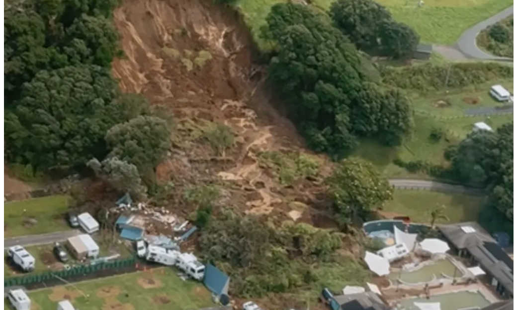
A huge deadly landslide came down at Mount Maunganui's Beachside Holiday Park about 9.30am last Thursday, smashing into campervans, tents, vehicles and an ablution block near the Mount Hot Pools.
Six victims have been named. They are: Lisa Anne Maclennan, 50, Måns Loke Bernhardsson, 20, Jacqualine Suzanne Wheeler, 71, Susan Doreen Knowles, 71, Sharon Maccanico, 15, and Max Furse-Kee, 15
It is not clear how engineer runout calculations might apply to the area.
The advice in 2005 has been superseded in part by new science that has led to the adoption of smaller runout zone sizes in the Mt Maunganui and Papamoa neighbourhoods, but the thrust was obvious - to steer clear.
"Only in rare circumstances would it be prudent to violate" the zone criteria, wrote two geotechnical engineers in the study into 300-plus landslides across Tauranga triggered by a big storm.
"Because of this we believe that the following changes to the criteria would be appropriate: 1. Buildings are not to be located within the [zone]. Only if special measures are taken, such as construction of properly engineered structures (ie retaining walls, piled foundations and deflection bunds) can these criteria be exceeded."
The old runout zones in Tauranga were calculated as '4H:1V' - four times the vertical height of the slope (V), extending horizontally from the base (H). The new zone in 2025 was suggested as half that - 2H:1V.
The study on this for the city council last year by engineering consultants WSP covered all the Pacific seaside neighbourhoods except Mauao (Mount Maunganui) itself. RNZ has asked the council why Mauao was not mapped, and also for comment on runout zones.

'Directed away from areas with an unacceptable risk'
Auckland Council has been sharing its country-leading work on landslides with Tauranga and the Bay of Plenty region. Tauranga was "unique" in how prone it was to rain-induced slips, WSP said in 2025.
Mayor Mahé Drysdale told RNZ's Morning Report programme they were setting up an independent review into the "facts and events leading up to the landslide".
Auckland Council said because of that review it was inappropriate for it to answer queries about landslide risk on Mt Maunganui.
But it laid out its own advances on landslide mapping that it said meant the information people could get about landslides on Land Information Memorandums, or LIMs, was more reliable, and its controls over what got built and where were better.
"Before our 2025 mapping, we didn't have good regional maps showing landslide susceptibility because we didn't have the data available to create them," chief engineer Ross Roberts said in a statement.
"This meant that it was more difficult to identify where activities were taking place in areas potentially susceptible to landslides."
It was also difficult and complex to apply controls to existing activities.
Since last year it could statistically model the landslide susceptibility, which was feeding into plans and LIMs.
"This means it can be used by people when choosing where to buy or rent a house, and by infrastructure and asset owners... Together, these mean that future development can be directed away from areas with an unacceptable risk, and existing assets can be assessed and their use modified if appropriate," Roberts said.
Checks on individual sites were still sometimes needed, such as when protective structures had been built, earthworks had changed the land profile or underlying characteristics were unusual.
'Avoid building in run-out areas'
Martin Brook, professor of applied geology at University of Auckland, said understanding landslide runout on Mauao was important because the maunga had a history of slips.
"Understanding and modelling the runout of landslides and where the detached material is going to run out and end up and possibly inundate is really important," he said.
"You should avoid building in run-out areas. That's sensible, and people would follow that advice in most parts of the Western world."
But the light-detection (LIDAR) tech used to detect historical landslides was not so useful for runout and he was not aware of much research on it.
"Most of New Zealand is under-researched from a sort of a geological standpoint."
The country had woken up recently to tsunami risk and signs and advice had sprung up, but had only begun waking up to the risk of landslides since 2023 though they were the country's most deadly natural hazard, he added.
'Reliant on outside advice'
Northland geotechnical engineer David Buxton said councils nationwide had really struggled since the 1990s - when they began shedding expertise - to get their own technical advice to back their decisions on the likes of runout zones.
"They're reliant on outside advice to give these things, but then they're reliant on in-house people without that depth of technical knowledge to make that decision-making, and I think it would be really good if councils were able to invest in that in-house technical ability."
Buxton himself, as a consultant, benefited from the current set-up, he said - however it was not just expensive, but led to patchy follow-through sometimes.
Auckland Council had invested in-house and that was paying off in its response to floods, Buxton said.
The WPS study for Tauranga last year had some gaps - for instance, it did not look at the likely size or volume of likely slips.
"The factors that determine the volume and runout characteristics of the landslide, and the consequent impacts on infrastructure in proximity to the slope, could be considered when looking at specific slopes as part of site-specific studies," said the short study, that sits alongside two longer engineering reports into landslides in the city and region.
"This should be carried out as part of considering the risk posed to infrastructure or property at particular sites."
The landslip map showed small zones of "failure" and runout at several streets, the largest of which were around Hopukiore Reserve.