The storm, if it arrives, will deliver strong winds, heavy rain and hazardous coastal conditions, MetService meteorologist John Law told Morning Report.
It might first hit Northland late on Saturday, but Sunday remained the key day. It was a category 2 storm with winds around 100kmh at its centre as of this morning.
Regions that have already seen a lot of wet weather this year might be in the firing line again.
"But by the time it reaches us in New Zealand it will still be a very deep very active area of low pressure and it's not just the windy weather but also that low pressure itself will help give a bit of a boost to the seas as well, just adding to those coastal conditions," Law said.
Wind gusts are expected to exceed 110kmh, especially in the Kaimai Range and along the hills and ranges in the east.
"There's plenty happening over the next few days. It's a very fast-moving system clearing through us as we head through Sunday-Monday."
Close to 20 heavy rain and strong wind watches have been issued this morning across the North Island from Saturday evening.
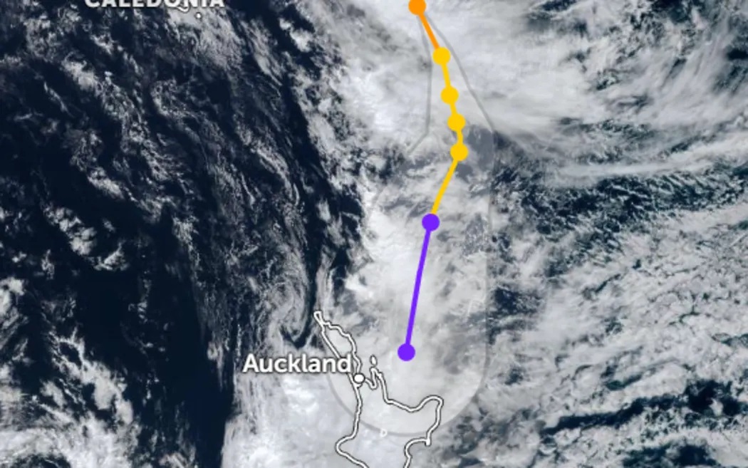
Clearer picture sought
MetService staff will be casting their eyes over the latest weather models on Thursday to try to get a clearer picture of what path Cyclone Vaianu could carve.
At the moment it was too soon to say, with the various models still showing different tracks.
The information MetService did have so far was enough for it to put the entire North Island under a strong wind watch for Sunday.
"I believe this is the first time that we have done this," forecaster Brian Mercer told RNZ.
"And that is just to reflect the fact that this is a very significant storm."
Mercer said although different tracks were being shown in modelling, it was very likely somewhere in the North Island would get strong winds and heavy rain.
The watches in place now were to give people a heads-up for risk throughout the entire island, he said.
"Model runs come in two or three times a day depending on which model it is, and as we get a little bit closer we're going to be looking at those and we will certainly be or very likely be issuing warnings, very likely orange warnings and potential red warnings," Mercer said.
"However, those are discussions that we have to have as we see the progress of the cyclone and as we have discussions with Civil Defence and local authorities in the relevant areas."
The uncertainty meant it was also too early to say when the existing warnings would be upgraded.
"So people need to prepare, they need to make certain that the gutters are clear, they need to make certain that, for example, trampolines and so on are not in a situation where they could fly away, they need to do all the normal things they do when there is a storm approaching," Mercer said.
"And it is a very high impact event, and so we have taken this step of actually issuing this initial phase earlier than we normally would and for a larger area."
What will MetService be doing today?
Mercer said expert forecasters would be going over the new models as they rolled in to see how they had changed from earlier ones.
They would also be tracking the cyclone's actual movements to see how it compared to tracking shown in modelling, he said.
"We can see that cyclone very clearly on the satellite imagery and we have a very close picture of where it currently is.
"And so as we see the later models come in, we'll see how they are developing with that," he said.
"And from there, they are going to have discussions with regional councils, with Civil Defence, and issue further warnings with more details.
"We will issue the warnings when we have sufficient certainty that we're not going to be crying wolves."
Agencies on 'full notice'
Prime Minister Christopher Luxon said on Wednesday that agencies were on "full notice" over the system.
"This is shaping [up] to be a very significant and damaging weather event, and I just think obviously with big impact on the North Island, particularly around Sunday, it's a great opportunity to remind New Zealanders to do everything they can.

"Stock up, get their supplies in order, get items that may be loose in their backyards tied down and in secure storage."
He said it was important people did everything they could to prepare.
Acting Emergency Management Minister Chris Penk told RNZ a nervous watch was being kept on the cyclone.
He said preparations were being made for a worst-case scenario, which included the Defence Force beginning preparations for possible deployments.
"The Defence Force are making plans to respond in the areas that they may need to respond," Penk said.
"Of course, the obvious challenge is that we don't know where and when the situation would arise, we can probably narrow down as the weather system gets closer to New Zealand what kind of timing might be at play, but the benefit of the Defence Force involvement would be that through its air assets in particular," he added.
"So they are on some form of standby and that will be formalised when it gets closer to the time of knowing where and when such assistance would be needed."
Penk said MetService, NEMA and Civil Defence Emergency Management Groups, the New Zealand Defence Force, Police and Fire and Emergency New Zealand were closely monitoring Cyclone Vaianu, and NEMA stood ready to coordinate support if needed.