
Access to Dunedin from the north has been restored with the reopening this afternoon of State Highway 1, which had been closed for much of the day.
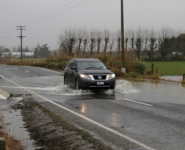
The highway was closed from Dunedin to Palmerston, and also north of Oamaru between Glenavy and St Andrews, owing to floodwaters over stretches of the road.
The Glenavy-St Andrews section opened just before 4pm, and the Palmerston-Kilmog section reopened about 4.40pm, Waka Kotahi NZ Transport Agency advised this afternoon.
The Waitati Hall and East Otago Events Centre were opened this morning to provide shelter and warmth to stranded truck drivers.
Orbus advises its Dunedin-Palmerston service remains suspended for now.
A short section of SH1 south of the Waitaki River is closed due to flooding at Hilderthorpe, but there is a detour in place via Seven Mile Road so people can get to and from Oamaru.
Motorists would still need to take care, Nicole Felts, Journey Manager for Waka Kotahi, said.
"Even after highways have reopened, people should be ready for slower journeys for some time.
“Everyone will need to take care with freshly created potholes in many places.
“Crews have done a huge amount of work today getting these roads safe enough to be opened. Not all drivers have been patient and we understand their frustrations, but these road closures are primarily for their safety.
“There is still a significant amount of surface water, flooding and road surface damage around with many warning signs out."

A council spokeswoman said people might want to consider traveling earlier or delaying travel in case the road closes.
Emergency Management Otago says power outages have been reported across coastal Otago today.
Emergency Management Otago Group Controller Matt Alley said a "significant amount of rain" had fallen in the North Otago and Dunedin areas, with some coastal areas having recorded rainfall totals from 110mm -150mm.
Mr Alley said while some rivers peaked on Tuesday night, such as the Kakanui in North Otago, Dunedin’s Water of Leith and Lindsay Creek and Taieri’s Silver Stream, he cautioned that the Dunedin catchments were still running high this evening.
The Dunedin City Council this evening said it was continuing to monitor the weather situation, but conditions were easing and the worst appeared to have passed.
A DCC spokesperson said the Emergency Operations Centre would stand down at 8pm today, as no major issues were expected overnight.
"However, key DCC and Civil Defence staff are on standby to be reactivated if needed and people can still report any urgent weather-related issues by calling 03 477 4000."
Roading crews would monitor the network throughout the night and respond to any urgent problems.
The spokesperson said tomorrow its focus would turn to clean-up and recovery.
"This has been a significant weather event, with up to 140mm of rain falling since yesterday.
"This has created challenges including ponding, slips and damage to some roads around the city.
"We’re encouraged that, generally, our infrastructure has held up well despite the challenges."
Earlier, the council said it was responding to 120 callouts today relating to slips, fallen trees and flooding around the city as rain continues to fall across the region.
Heavy rain warnings were in place for Dunedin and North Otago and a heavy rain watch has been put in place for Clutha.
Dunedin's heavy rain warning was extended until 3pm today and North Otago's until 2pm.
Clutha can expect periods of heavy rain until 11pm tonight.
MetService had earlier expected the rain to ease off by mid-morning.
Another 15-20mm of rain is expected in Dunedin and North Otago, on top of what has already fallen. Accumulated rainfall reached up to 140mm across Dunedin and 120mm in North Otago in the 24 hours until this morning.
Some North Otago schools have closed for the day, including Five Forks, Maheno, Omarama, Duntroon, Ardgowan, Kakanui, Totara, Hampden and Maheno Kindergarten
In Dunedin, East Taieri School and Preschool are also both closed.

A DCC spokesman said despite the callouts, there were no reports of major damage to property and the city's infrastructure appeared to have "coped well".
Twenty-seven roads are closed around the city, including the Coast Road around Karitane, which is among the worst affected. A full list of closed roads is at the bottom of the page.
Dunedin Mayor Aaron Hawkins said this morning that the worst of the rain appeared to be over and there were no further evacuations overnight.
"We're expecting a bit more rain over the day ... and we're keeping a watching brief on some of those rivers in outlying townships in particular, but overnight we seem to have dodged a bullet," he said.
There had been no major flooding but Dunedin Civil Defence emergency management were continuing to watch streams and rivers, particularly Lindsay Creek and the Water of Leith in North Dunedin.

The Waikouaiti and Taieri Rivers are also being monitored.
By 12.30pm, the Water of Leith and Lindsay Creek had started to drop but were still being closely monitored.
Dunedin City councillor and farmer Mike Lord said there hadn't been as much rain south of the city as in Dunedin. The Taieri River was on the rise and there could still be flooding on low-lying farmland, but generally the flood protection systems were coping well.
Police said a sinkhole had opened up on Gladstone Rd in Dalmore, near Aquinas College, overnight. The road is closed.
Water flowing down Gladstone Rd caused the sink hole to open up further while police and contractors were on site.

There were also multiple slips on Portobello Rd, police said.
Seventy-one people from 26 addresses in some low-lying North Dunedin flats near the Water of Leith were evacuated last night as flood waters threatened properties.
They were allowed back early this morning and only a small number of people used the evacuation centre at Dunedin North Intermediate overnight.
Campus Watch staff door-knocked about 35 affected properties between Montgomery Ave and Leith St central late yesterday afternoon to warn residents of possible flooding.
A Dunedin City Council spokeswoman said students were told to consider leaving their flats if they had somewhere else to go, and those who chose to remain were asked to have a bag packed and be ready to move at short notice.
Leith St resident Aimie Clark (21), of Christchurch, said she and her flatmates did not leave on the first request, believing they would be safe as long as water did not come through their back fence.
But they got a fright when they were told evacuation was no longer voluntary, she said.

"It’s half and half, a bit scary and an adventure at the same time."
She took a bag packed with her passport, a laptop and other electronics, and a change of clothes, and planned to bunk down at a friend’s place.
Blacks Road Grocer was inundated with about 15cm of floodwater in North East Valley yesterday and was too damaged to open today.

As a precaution, several patients were evacuated from the Otago Community Hospice, in North Rd, to Mercy Hospital last night.
The city council had organised an evacuation centre at Dunedin North Intermediate and alternative accommodation options were also available.

North Otago
Floodwaters are beginning to ease in North Otago but consistent light rain means roads are unlikely to clear any time soon, a Waitaki District Council spokesperson says.
More than 37 roads in the area are closed many are likely to stay closed tomorrow, affecting school bus routes.
Waitaki mayor Gary Kircher said conditions were particularly difficult for farmers at what was already a busy time of year.
"We thank everyone for their patience and cooperation as the widespread flooding issues continue and we ask that people keep hunkering down and staying off the roads where possible.
"Our crews are out there doing all we can to look after the current situation and we will be getting our contractors to assess the damage and start the clean-up once conditions improve."
In Maheno, flooding concerns forced Maheno School to close early yesterday.
Principal Stella Macrae said she warned parents earlier in the day about the situation and all 64 pupils had been picked up by 2.15pm.
A post on the school’s Facebook page this morning announced the school would remain closed all day Wednesday.At 4.30pm on Wednesday SH82 (Ikawai to Kurow) was closed due to flooding and would be reassessed tomorrow morning, NZTA said.
SH1 through Hampden is open but Big Kuri Creek has burst its banks and water has covered the bridge.

In Oamaru, Old Mill Rd and Parsons Rd were closed this morning due to flooding, along with more than 37 other roads around the district.
A Waitaki District Council spokesperson said the Kakanui River had plateaued overnight but was rising again early this morning. The Shag and Grange Rivers were also high and continuing to rise.
Emergency Management Otago urged people to remain vigilant of water levels in their area, particularly in areas more susceptible to flooding.

Clutha
Further south, Clutha District Council said consistent rain had caused surface flooding on at least 30 roads throughout the area.
Crews were out this morning to signpost any flooded areas but due to the extent of the flooding, CDC said not all affected roads would have signage.
High tide in the area is due at 2.15 and more coastal roads are expected to be inundated.
Otago Regional Council engineering staff were positioned at vulnerable rivers and streams overnight, while emergency services, lifeline agencies and staff from the Clutha District, Waitaki District and Dunedin City Councils watched the situation closely and were prepared to act as events unfolded.Emergency Management Otago group controller Matt Alley asked residents to continue to observe boil or conserve water notices and ensure their household plans, emergency supplies including stored water and getaway kits were prepared.
"We’re keeping a very close watching brief on the situation right across Otago, and are ready to escalate if necessary," he said.
In Canterbury, schools closed, businesses were inundated and dozens of roads closed around Christchurch as heavy rain lashed the region.
More than 70mm of rain had fallen in the 24 hours to yesterday afternoon, amid the city’s wettest July on record.

Flooding also forced pupils from Christchurch Girls’ High School to study from home.
Principal Christine O’Neill said it was the first time anyone could remember floodwaters closing the school.
Dunedin road closures
Many roads around Dunedin itself were closed because of flooding, including Three Mile Hill Rd, Dalziel Rd, Brinsdon, King George Memorial Drive, Hatchery Rd, Apes Rd between SH1 and Round Hill Rd, Leith Valley Rd between Malvern St and Poulter Rd due to a slip, Mt Cargill Rd between Upper Junction and Shortcut Rd, Blueskin Rd between Shortcut Rd and Purakanui Rd, Burma Rd between Polwarth and Cannington Rds, McGrath Rd (at Waikouaiti River bridge), Surrey St (between Hillside Rd and Ruskin Tce), Ravensburn St (Woodside), Old Brighton Rd (between Walton Park Ave and McMaster Rd), Waitati Valley Rd, Miller Rd (at Waitati River ford), Southdale Rd (at Tautuku Fishing Club), Gladfield Rd (at Silverstream ford), Silverstream Valley Rd (at Silverstream ford) and Flagstaff-Whare Flat Rd, and Portobello Rd (between Marne St and Vauxhall Yacht Club) was closed due to a rockfall hazard.
State Highway 87 to Middlemarch is open but surface flooding means speed restrictions are in place.
— Additional reporting ODT Online & RNZ


