
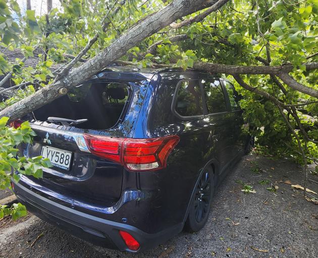
A person in Dunedin received minor injuries when they were hit by a flying trampoline and Hato Hone St John was also called to the scene when a tree branch fell on a car in the city today, but nobody was hurt.
One person suffered moderate injuries in a weather-related crash on the Milton Highway in the afternoon, a spokesman said.
Dunedin Mayor-elect Sophie Barker drove along Portsmouth Dr on her way home and said she saw "many trees down and debris everywhere".
"People need to be very sensible. Stay home. Stay safe."
Assistant National Commander Ken Cooper says between 7.40am and 5pm today, crews were called to 587 incidents.
"Wellington and Canterbury saw the most callouts in the early morning, before Southland was hit hardest at lunchtime."
Crews responded to 228 calls between 11.55am and 5pm in Southland, including 155 in Invercargill.
"This is for things like roofs lifting, trees down, power lines down, garage doors, fences and sheds blowing away. The rain has stopped, and the wind has eased, so now crews will now be looking to assist with clean-up across the region."
Many highways affected, road snow warnings
The New Zealand Transport Agency said roading teams were continuing to clean-up and monitor several state highways across the central and lower South Island which will remain closed overnight.
"A number of closures were put in place where the winds were putting road users at risk and creating obstructions on the highways. While the winds are now easing in places, people are still being urged to avoid unnecessary travel tonight or to take extra care given that hazards may still exist on the roads," a spokesman said.
State Highway 8 between Lawrence and Waitahuna, and SH96 between Mataura and Hedgehope, have reopened tonight after closures during the severe winds.
SH8 was affected by fallen trees, while trees and power lines were brought down on SH96. Both roads have since been cleared, the spokesman said.
"Roading teams have also been alerted tonight to a separate incident of a fallen tree blocking SH8 at Waitahuna, near the intersection with Sunderland St. Road users should take care through this area."
Meanwhile, a heavy road snowfall warning has been issued for Southland's Milford Road from 8pm today until 5pm on Friday.
SH94 was already closed from East Gate (Hollyford) to Donne River (Westgate) due to a high risk of avalanche and forecast snow of up to 15cm tomorrow. It was now also closed from Park Boundary to East Gate due to slips and fallen trees.
Snow showers may also affect the Crown Range Road, linking Queenstown and Wanaka, from 9pm to 11pm today, MetService advised.
Otago homes without power overnight
PowerNet, the electricity management company for Southland and parts of Otago, says staff have been responding to "unprecedented wind damage" to its networks as it works to understand the full extent of the issue.
"We are managing some incredibly dangerous situations including dozens of power poles and lines down on roads, trees fallen onto lines, and broken or snapped power poles," it said in a statement.
Tens of thousands of homes, businesses, and key facilities remained without power, many of which are likely to be without power overnight, it said.
Lines company Aurora Energy said at the peak of today's extreme weather, 1600 customers across its Otago network were without power and some would be without it overnight, though it couldn't say how many.
“Due to the scale of storm damage on our electricity network, particularly in Dunedin, some customers will not get their power restored this evening. While we are doing everything we can to restore supply to as many homes as possible tonight, some outages will extend into Friday,” Matt Settle, Aurora Energy general manager future network and operations, said in a statement.
“Our fault crews will continue working as long as possible this evening but will eventually be stood down overnight to manage fatigue and ensure they are ready to continue in the morning.
"At this stage, we’re unable to confirm which customers will be affected overnight. We’ll provide updates on our website and Facebook page later this evening as more information becomes available," Mr Settle said.
A reduced level of fault crew would remain on call overnight to respond to emergencies, with full repair efforts resuming from 8am tomorrow.
"We’re sorry we can’t restore supply to everyone today, but we’ll be back at first light to continue repairs."
Due to the high volume of outages, Aurora Energy’s website had experienced delays in updating outage information. Their IT team was working urgently to resolve this, he said.
“Our control room has been extremely busy today and even if a fault isn’t showing on our website, it’s likely we’re aware of it, but if it’s not there tomorrow please let us know."
The wind also caused some damage to the Dunedin Ice Stadium roof and at Forbury Park in Victoria Rd, while the Dunedin Railway Station lost tiles from part of its roof.
Forsyth Barr Stadium suffered minor damage to some roof flashings, the Dunedin City Council said.
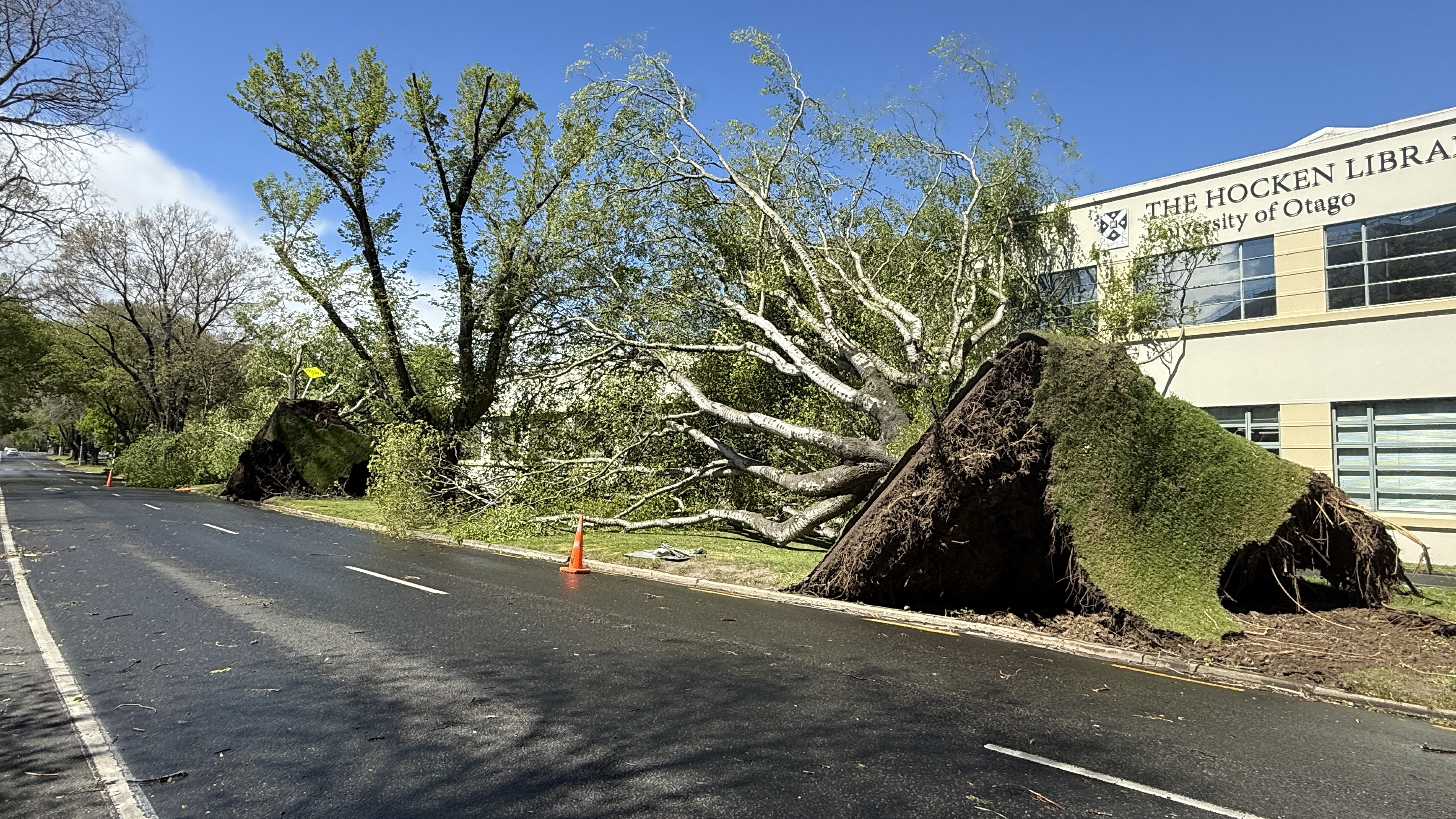
DCC contractors have logged more than 50 jobs across the city’s roading network, mainly involving fallen trees.
There were 11 road closures in effect and contractors are clearing and reopening roads only where it is safe to do so.
The road closures include Highcliff Rd, while Portobello Rd was down to one lane in places. A full list of road closures can be found here.
In Dunedin, the biggest gust recorded by Port Otago's wind equipment was a gust of 170kmh at Taiaroa Head at 1.50pm.
In the inner city, the biggest gust recorded was 100kmh at 1.40pm at the T-shed on the wharf.
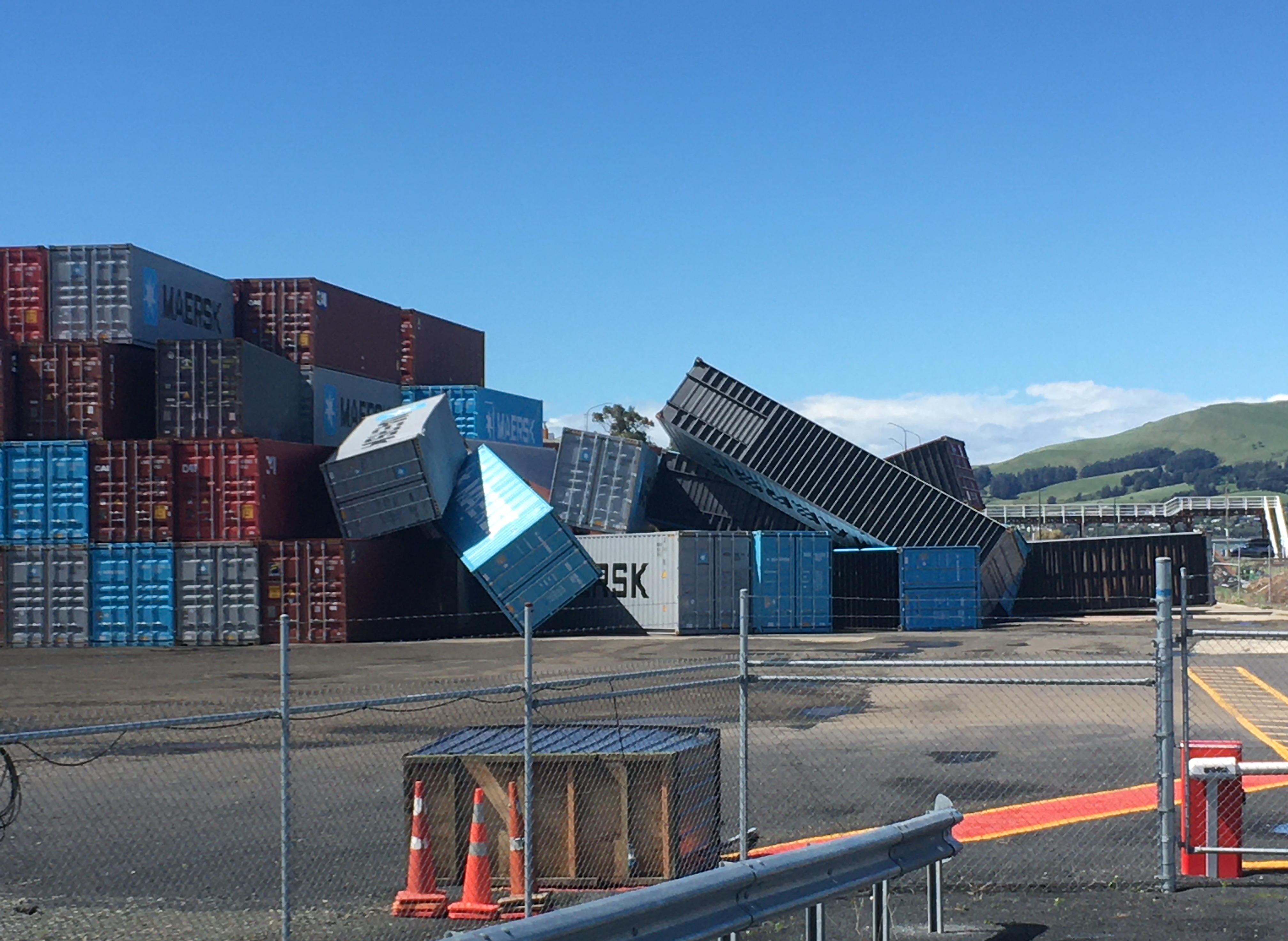
Port Otago chief executive Kevin Winders said multiple 40ft closed and empty dry shipping containers were moved by the wind at the Ravensbourne container depot.
‘‘They each weigh about two-and-a-half tons, so the wind was pretty intense to be able to move them around like that.’’
He said their team at the depot ‘‘did a great job,’’ and were prepared for them to potentially topple.
Winds were still ‘‘quite blustery,’’ and the clean-up would not begin to start until they died down. They would use titan cranes to re-stack the containers tomorrow if possible.
No staff members were around the containers when they went down, Mr Winders said.
The Dunedin Botanic Garden is closed for the rest of today due to the high winds and increased risk of tree and branch fall.
A video shows students running as trees come down outside the University of Otago Business School.
A caravan has been tipped on its side at Allanton, blocking the bridge across the Taieri River.
Dunedin Airport's website shows multiple cancellations and many flights in and out of Queenstown Airport have also been cancelled.
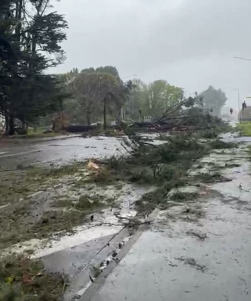
Motorists use chainsaws to clear Portobello Rd
Keith Dickson, of Dunedin, said two big lines of trees had come down on Portobello Rd about a 1km apart near Glenfalloch.
He was at the front of a line of cars, he predicted hundreds were caught up on the road, that had to stop for fallen trees.
He had praise for his fellow Dunedin citizens, who, he said, came together to clear one lane and let vehicles pass.

"I'm just really proud of Dunedin people because everyone got out of their cars and, without complaint, worked like we were a team, I'm amazed."
The road remained "extremely dangerous", he felt, and urged caution for anyone needing to drive there.
"The cliffs there don't look great, it's bloody dangerous. There's going to be a hell of a lot of work there to clean up and stabilise it all."
'Bang' of wild weather
MetService meteorologist Claire O'Connor said the south was mostly in the clear after the ‘‘bang’’ of bad weather that just made its way through Southland and Otago.
‘‘The main stronger winds are moving off to the east now - you’ve probably noticed the temperature has had a bit of a drop as well.’’
Dunedin reached 25°C just before the winds hit, and dropped right down to 15°C within half an hour after they had passed over the city.
The South may still get a few strong gusts, but the worst had so far subsided.
Southland smashed in sudden burst
MetService upgraded its Southland and coastal part of Clutha to a red warning just before noon today, with a forecast of damaging gusts of 150kmh in exposed places. By 1pm, the wild wind had reached Balclutha, cutting power and sending debris flying.
In a statement tonight, Emergency Management Southland said the warning had been lifted for coastal Southland at 6pm but there were reports of widespread damage across the region to homes, buildings and roads.
EMS controller Lucy Hicks said people should continue to avoid unnecessary travel within Southland and to other regions.
“There are trees and powerlines down across the lower South Island, and road closure signs are limited due to the wind.
“Power is still unavailable across large parts of Southland. Tonight, we encourage people to stay put, stay warm and dry. This might mean staying with friends, family or neighbours.”
PowerNet were prioritising staff and public safety, addressing the live powerlines, and would be restoring power as swiftly as they can once any damage has been assessed, she said.
"If you notice damage to lines or other electricity equipment - do not approach it. Please call Powernet ASAP - 0800 808 587. Restoring power will be prioritised to critical services.
"If you are concerned for your safety, please call 111. If you have damage to your property, please reach out to your insurer and/or landlord.
“It is expected the recovery from this weather event will go on longer than the incident itself, with power, water and communication outages expected to continue across the next couple of days.”
Southland had been hit hard, with Invercargill city’s top gust reaching 137kmh and Gore getting a 125kmh gust.
Meteorologist Claire O'Connor said this was due to the region getting the brunt of the front after it came from the sea.
‘‘It passed over land and the friction of the land can just disrupt everything and make it separate a bit more... that will cause that to slow down, sort of drags on everything a bit.
‘‘Over sea, things will tend to pick up because there's just the ocean surface there - in this case, the land dragged back those speeds a bit there.’’
The Southwest Cape, at the southern tip of Stewart Island, for example, got the full brunt of the wind as it came from the sea, she said.
The station recorded a top gust of 190kmh. ‘‘It’s straight off the ocean there.’’
Tree 'came out of nowhere'
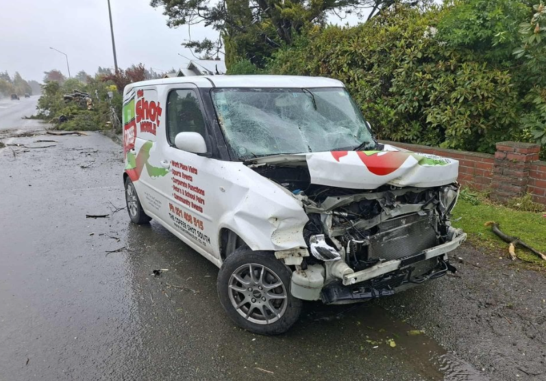
A coffee van owner in Invercargill got a big shock when a large tree crashed on her bonnet as she was driving today.
The Shot South owner Justine Abbott told RNZ said she was on North Rd when the tree "came out of nowhere."
She had just decided to head home in the worsening weather conditions.
"I started slowing down, and it went 'boom.'"
Abbott said she had escaped without injury, but the van was "pretty much written-off."
In her shock, she said she rang to organise a replacement vehicle before she even got out of the van. She hoped to be back in business next week.
Invercargill City Council said multiple trees fell across the city and flying debris posed a serious safety risk.
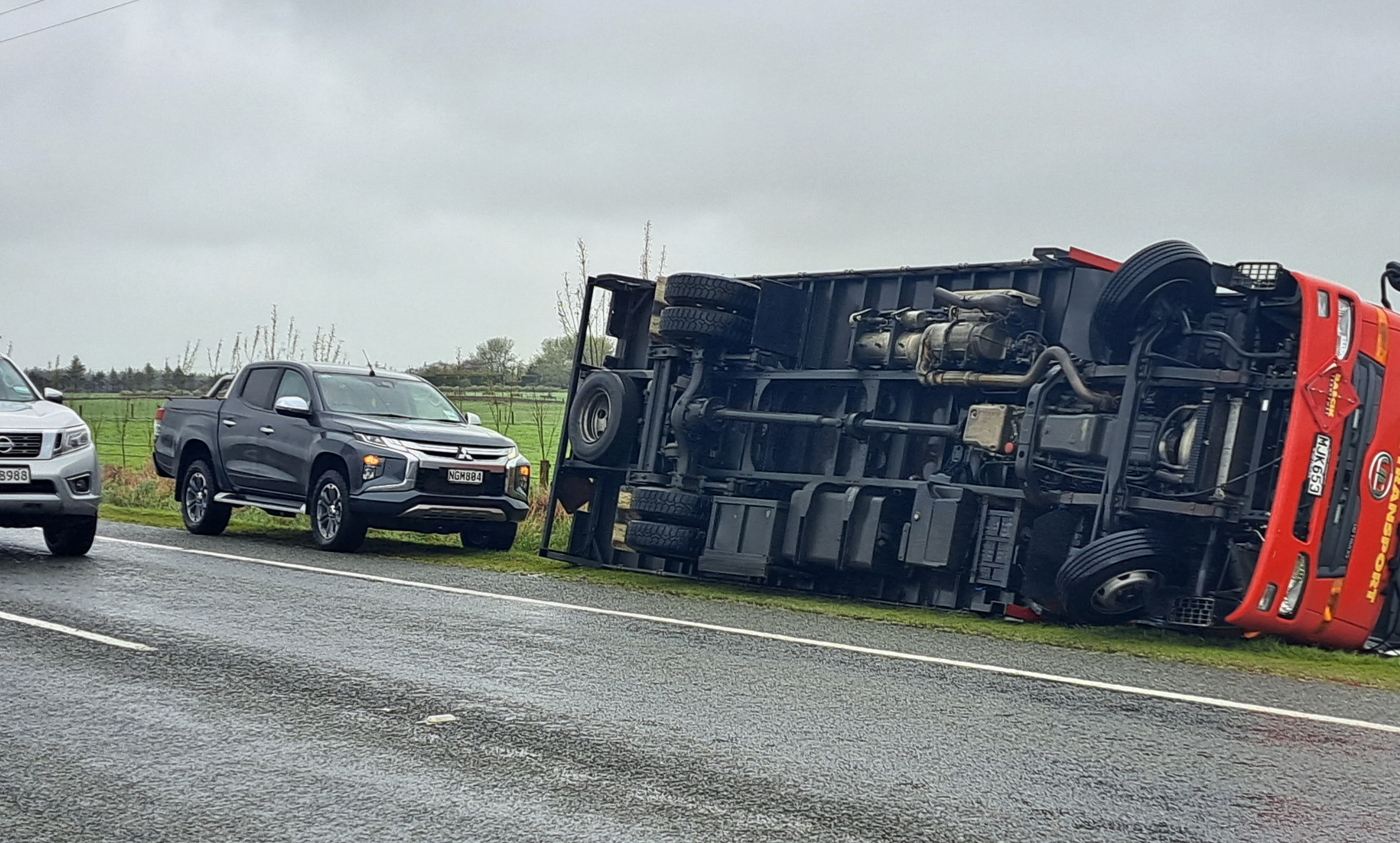
A freight truck and trailer tipped over on State Highway 1 between Clinton and Waipahi.
Roads were closed across the city including Elles Rd, Inglewood Rd, Queens Dr from Herbert Str to Rugby Park and SH1 East Road.
The sign on Allied Media's building had also been ripped from the sign of the building and the street was flooded. She said the weather suddenly turned "ballistic" and she had never seen anything like it.

All Invercargill bus services are suspended until further notice and parks and reserves in Invercargill and Bluff are closed.
Bluff Service Centre was also closed for the rest of the day.
Chaos in Mataura
A Mataura man described scenes of destruction around Mataura and Edendale.
Lines of trees along the sides of the road between Gore and Edendale were down, as were farm shelterbelts and fencelines, half the roof of a $150 million long life cream plant under construction at Fonterra at Edendale had blown off and a trampoline had blown on to his neighbour's roof.
The man, in his early 50s, had lived in Mataura his whole life and had never seen wind like it, he said.
It was still "blowing it's t*** off" at 2.50pm, and the wind had been going since 10am.
He said the wind was coming from the east, which was unusual.
South Island highways
The wild weather has affected many highways in the South Island, the NZ Transport agency advised.
In Otago/Southland, State Highway 1 between Gore and McNab would remain closed overnight.
The Milford Road (State Highway 94) is closed from East Gate (Hollyford) to Donne River (Westgate) due to a high risk of avalanche and forecast snow of up to 15cm on Friday, and closed from Park Boundary to East Gate due to slips and fallen trees.
State Highway 6/North Road in Invercargill, between Bainfield Rd and Renfrew St, is also closed, with an update expected tomorrow.
State Highway 6 between Lake Hawea and Maungawera is closed.
State Highway 1/Bluff Highway near Omaui Rd is open under stop/go traffic management.
In Canterbury/West Coast, the stretches of state highways that are still closed, and are expected to remain closed overnight, are:
- State Highway 73 between Springfield and Otira (Kumara to Otira reopened recently).
- State Highway 7 between Waipara and Springs Junction.
- State Highway 7A, from the Hanmer Springs turnoff.
- State Highway 6 between Haast and Makarora (Haast Pass).
- State Highway 6 between Murchison and Wai-iti.
People are asked to avoid the closed highways above. Further updates on the status of these roads were expected tomorrow.
State Highway 1 through Canterbury remains open, and State Highway 80 between Aoraki-Mount Cook and State Highway 8 has reopened, but surface flooding and strong wind warnings will remain in place overnight on SH80.

Southern Lakes
Power is out to more than 1000 customers in the Southern Lakes area.
Aurora Energy's website shows widespread outages including in Queenstown, Glenorchy, the outskirts of Wanaka, Te Anau and Makarora.
The Queenstown Lakes District Council says its emergency operations centre is tracking rain, river and lake levels across the district.
The following roads are closed due to flooding:
- SH6 (Haast Pass) between Makarora and Haast.
- Mount Aspiring Road after the Treble Cone turn-off; there is currently no access to Mount Aspiring National Park.
- Glenorchy-Paradise Road at the Rees River Bridge.
- Rees Valley Road north of Glenorchy.
- Glenorchy-Queenstown Road at One Mile
- Moke Lake Road at RP 3.17 (i.e. third cattlestop).
Many other roads are affected by surface flooding and rockfalls; please drive with extreme caution – slow down, increase following distances and keep headlights on.
Leslie van Gelder, who lives in the Rees Valley, told the Otago Daily Times she lost power about 11am.
The Rees Valley Rd was closed by the Queenstown Lakes District Council about 9.30am.
 ‘‘It was kind of expected, which would go first, the road or the power,’’ Ms van Gelder said.
‘‘It’s pretty wild up here. I’m guessing the eye of the storm is coming through ... we’ve just had wind that was circular, not a tornado - I’ve never seen that before.’’
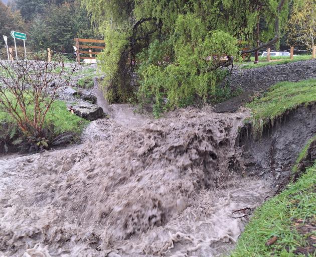
Lakes Wakatipu and Wanaka should be peaking tomorrow morning, the Otago Regional Council says.
ORC’s general manager science and resilience Tom Dyer said MetService has now cancelled its orange heavy rain warning for the Otago headwaters and most rivers have peaked and were falling.
“While the rain has largely passed both Lake Wakatipu and Lake Wanaka are still expected to rise over the next 24hours,” Mr Dyer said.
He cautioned that while many rivers were now receding around the Queenstown Lakes area, further rain forecast for later today could prompt some rivers to rise again.

Around Queenstown there was potential for surface flooding and localised ponding in low-lying areas of Beach St, Rees St, Marine Parade, Church St, Earl St, as water entered through the stormwater system, with precautionary sandbagging under way.
Low-lying parts of Kingston township were expected to flood, while in Glenorchy the outlook remained unchanged from yesterday.
The Glenorchy lagoon was predicted to overtop the Glenorchy floodbank, and flooding of the northwest part of the township was still likely on Thursday night.
Queenstown Airport sustainability and corporate affairs general manager Sara Irvine said while there were a lot of people at the terminal who had been disrupted, but due to the extent of the cancellations across the domestic and international networks ''it's not very crowded''.
Ms Irvine said staff had been advising passengers due to travel today to contact their airline directly, or check the Queenstown Airport website for the most up-to-date information.
"We know that some of the airlines will make decisions a bit later in the day ... going into the long weekend there could be some ad-hoc flights to try and support disrupted passengers, but that's not confirmed.''
Those who were due to travel from Queenstown Airport this weekend were also advised to consider alternative methods of getting to the airport, such as park and ride, because ''it's likely the Queenstown Airport parks will be quite full".
- Allied Media


