PHOTO
Wild weather has lashed much of New Zealand, cutting power, closing highways, and causing flooding and chaos for air and road travellers.
- South feels wrath of wild weather
- Slideshow: A day of wild weather in South
- Check highway closures here
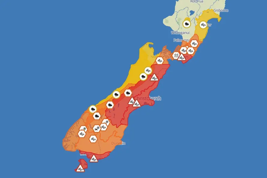
MetService had earlier issued a raft of severe weather alerts, including red strong wind warnings for parts of the South, and further north in Canterbury, Marlborough and Wellington today.
By this evening they had been lifted in the North and South Islands, although the Tararua Ranges was under an orange heavy rain warning until 8pm and an orange strong wind warning until 3am on Friday.
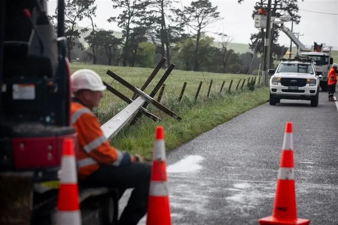
Power remained out for tens of thousands across the country as forecast wild winds wreaked havoc. Lines companies are warning customers they may be without power overnight and some could be out for days.
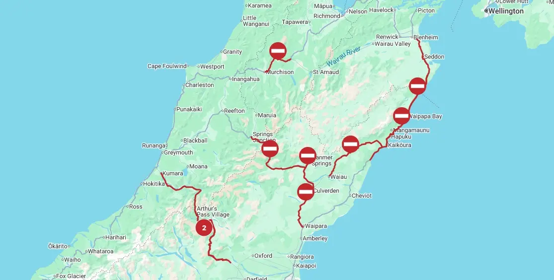
There are widespread highway closures across the South Island owing to slips, fallen trees and surface flooding. The West Coast is cut off as the last open highway floods.
Canterbury residents urged evacuate
Selwyn District Council is warning tonight that heavy rain in the Rakaia River's headwaters has caused it to rise rapidly and it is now in "significant flood".
Because of the high volume of water there is a risk the river may break out onto State Highway 1 and further downstream at the Rakaia Huts, it said.
Water is expected to reach the Rakaia Huts settlement about midnight tonight, but the council said it is advising residents to be prepared and evacuate to friends and family now if they can.
"Door knocking is taking place in the area."
If there is immediate danger to life or safety, please dial 111, the council said.
If you require support please contact Selwyn District Council on 0800 SELWYN "
Meanwhile, Environment Canterbury says the Waimakariri River is in high flood and is recommending that residents in the Kairaki / Pines Beach area prepare to evacuate.
It's also suggesting residents of the secondary floodplain (McLeans Island/Coutts Island and Templars Island) also prepare for potential evacuation.
A state of emergency remains in place in Canterbury.
Huge wind gusts keep fire crews busy
Fire and Emergency New Zealand (Fenz) crews were kept busy responding to hundreds of weather-related callouts, predominantly for roofs lifting and trees down.
They also had to deal with fences down, sheds blown away, a loose satellite dish on a roof and unsecured trampolines.
Assistant National Commander Ken Cooper said between 7.40am and 5pm today, crews attended 587 incidents.
"Wellington and Canterbury saw the most callouts in the early morning, before Southland was hit hardest at lunchtime."
Crews responded to 228 calls between 11.55am and 5pm in Southland, including 155 in the city of Invercargill.
MetService said a "huge" wind gust of 230kmh was recorded on Pudding Hill in the Marlborough region earlier today. The weather station now appeared to be offline.
Duty forecaster Silvia Martino said Mount Cook Aerodrome had a 156kmh gust, while Invercargill Airport had been buffeted by gusts of up to 137kmh.
Meanwhile, Fenz Te Ihu region manager Brad Mosby says firefighters are still dealing with fires in Hanmer Springs, Kaikōura and Waiau in North Canterbury.
Transport disruptions
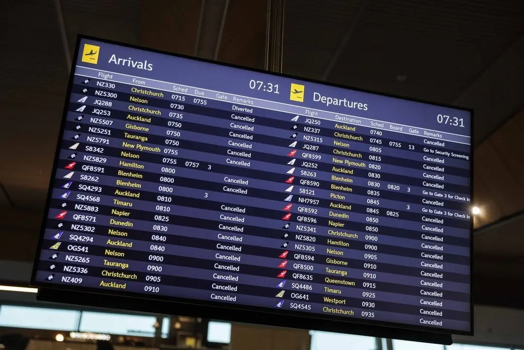
At least 220 flights were cancelled from early today, including at Wellington, Christchurch, Dunedin, Queenstown and Invercargill airports.
Flights had resumed in hard-hit areas of Wellington and Christchurch as gale-force winds eased by 6.40pm.
Christchurch Airport this afternoon said it was open and operating, "but the strong winds are causing flight cancellations, disruptions and delays".
Air New Zealand said it was offering flexibility to passengers travelling through Wellington, Christchurch or Dunedin today as the severe weather moved across the country.
The airline said travellers booked on flights between 6am and 6pm could change their bookings free of charge to any time within 48 hours of their original flight. Changes can be made directly through the Air NZ app.
Greater Wellington Regional Council said all Metlink train services for the rest of the day have been cancelled to allow KiwiRail to conduct safety inspections on the lines.
Only the Kāpiti and Hutt Valley Line services will be replaced with buses this evening. All scheduled train services in the capital were expected to resume on Friday morning.
Power outages
A massive power outage hit the upper South Island, cutting electricity to about 90,000 households, but most customers had it restored by late morning. However, Transpower advised that there could be ongoing outages throughout the day.
Many businesses were forced to close due to the outage and some were operating cash only.
Transpower's executive general manager Mark Ryall told RNZ's Nine to Noon programme there were three big transmission circuits for the upper South Island which had all tripped.
Nelson City Council said the power outage included Nelson, Hanmer, Greymouth and Blenheim.
The Hurunui District Council said trees had fallen across a powerline and multiple roads.
MainPower's website said was aware of the outages and was working to restore supply.
Power was also out to thousands of customers in parts of the North Island. At 2.55pm, Powerco's website showed nearly 5000 customers without power.
'Relentless spring'
MetService head of weather news Heather Keats said pretty much all of the eastern side of the country would experience strong winds today.
Keats told RNZ's Morning Report programme the destructive weather would impact all of the South Island and most of the lower North Island. The warnings should not be ignored and there was a threat to life.
The weather system was fast-moving and would improve later in the day. However, more bad weather would return on Monday.
Despite this, there would be unusual heat, with Hastings reaching 30°C.
"This spring has been relentless. It does feel like it has been system after system after system."
The stronger winds this week were more than MetService would usually expect to see for this season, she said.
State of emergency continues in Canterbury
Emergency Management and Recovery Minister Mark Mitchell yesterday declared a state of emergency for Canterbury, which was expected to bear the brunt of the weather.
"I have made this declaration as the Canterbury mayors have not yet been able to be sworn in following the recent local elections," Mr Mitchell said.
"The National Emergency Management Agency have been in close contact with the Canterbury Civil Defence Emergency Management Group and confirmed that a declaration is necessary.
"The state of local emergency will ensure local Civil Defence have access to the emergency powers they need to respond and support emergency services during this event."
john.lewis@odt.co.nz/additional reporting RNZ/ODT Online