A bird’s-eye view must reveal its special characteristics as more welcoming still — a wealth of cliff-top habitat surrounded by ocean.
So, they are present in wonderful diversity.
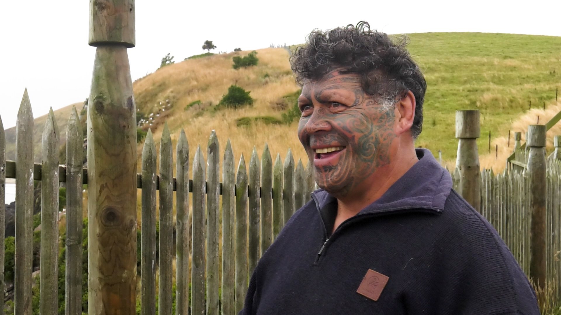
Kaitiaki Patrick Herewini-Tipa and Nola Tipa know them well — both the birds and the land they nest on.
"We’ve got the red-billed and the black-billed gulls here, we’ve got terns," Nola says.
"There’s so much other life here on the pā."
Close your eyes and those lives become clearer still, the incessant call and answer of the gull colonies rising above the surf sounds below.
The kaupapa matua (management plan) for the Kātiki Point reserve names a whole lot of other manu. There are hoiho, yellow-eyed penguin, and kororā, little blues, prion of several species and tītī too. The list goes on.
Tipa is a member of the Kātiki Advisory Group, who oversee the management plan — a joint effort by Te Rūnanga o Ngāi Tahu, Te Rūnanga o Moeraki and the Department of Conservation Te Papa Atawhai — and are working to ensure there will always be a place for them here, he kāinga haumaru, a safe home.
But that’s just part of the endeavour, because Kātiki Point’s dramatic geography also made it ideal for human habitation — a natural fortress strong enough to have withstood all that Tangaroa could throw against it.
So, together, Patrick and Nola are also working to preserve the human history that lies here on the land.
"We’ve lived here now since, about 14 years, since the Christchurch earthquakes, when we moved down here, afterwards. And it was Pat saw this place, and he decided this would be his legacy. He would regenerate everything here at the pā and recreate it," Nola says.
The pā is Te Raka-a-Hineātea, a pā tūwatawata, a fortified pā associated with the 19th century Ngāi Tahu rangatira Taoka, and it is already re-emerging from memory to again sit proudly on the point as a result of Patrick and Nola’s work.

The palisades reconstructed so far appear to stand naturally here, either side of "the neck", a narrow bridge of land above steep cliffs that leads to the furthest reaches of the point’s southward-leading peninsula. Certainly, the gulls nesting thickly around the cliff tops seem happy enough to share the space.
Alongside the work of building back the pā, Patrick has been busy restoring the vegetation along this most exposed section of the point, concentrating on plant species that can cope with the salt spray.
"So, we have a lot of harakeke, the hardier growing species of natives that are grown here," he says.
But there’s also a wildlife management reserve on the point’s eastern flank, below the lighthouse, where planting is denser and involves a greater variety. Ngaio, tōtara and mataī all feature, chosen based on information gleaned from historical archives.
That name, Te Raka-a-Hineātua, tells another story, stepping out of history to maintain an ancient whakapapa.
"It’s understood that Māui actually circumnavigated this South Island, and when he saw this place he named it after his father and his grandmother," Nola says.
"So, Te Raka was his father. Hineātea was Te Raka’s mother, so Māui’s grandmother."
Today, walking down to the point from the carpark, it’s easy for a visitor’s attention to be drawn first to the Kātiki Point Lighthouse, then the long thin peninsula beyond the palisades.
What these striking features help to obscure is that between the two, you pass through the village terraces that Taoka and his people established here, the clear evidence of a pā nohoanga tūturu, permanent settlement. It is landscaping that survives still.
It’s thought the pā was the hub for a community of up to 2000 people, not all concentrated at Kātiki Point all the time, but spread out along the neighbouring coastline.
Food was abundant hereabouts, both on land and in the sea, including at the neighbouring Waimātaitai lagoon. Barracouta, ling and red cod were all staples. Seals and shellfish were also on the menu.
The island of Maukiekie, just off the Moeraki Peninsula, was a nesting spot for tītī.
"They’d go over, harvest the tītī, bring them back to the mainland, which was Moeraki, and they would divvy them up between the families that lived here," Patrick says.
Over time, shags came to dominate on Maukiekie, destroying the vegetation the tītī needed, but tītī are slowly but surely returning to Moeraki, he says.
Those settled around Kātiki also continued to participate in other seasonal food gathering expeditions, perhaps heading up to the neck at Hāwea for whitebaiting, and there would have been further trips along the pounamu trails.

"This over here was the tauraka waka [landing place] where they pulled in, there’s big trenches out there," Nola says, indicating a beach below the neck.
"So, they pulled their waka in and up on to the hills."
Turning back towards the lighthouse, she indicates the hillside terracing where houses stood, the most extensive in southern Te Waipounamu.
"They’re described as rectangular boxes, slightly slanted to allow for drainage," she says of those dwellings.
Archaeological investigations indicate tōtara was the principal material alongside greywacke paving and stone hearths.
Further up the hill there are two big indents that would have been umu, ground ovens.
"Some of those terraces is where the gardens actually were as well," Patrick adds. They followed the hillside around to catch the morning sun.
The pā site was also chosen for its natural defences.

"And there is a kōrero that the island, the little island that juts off this, in times of war, or when a war party was sighted, the women and children went over to the island because you can only access it at low tide, so they were quite safe there. Then the skirmishes would happen here, and then they would come back."
The most celebrated of these encounters is the battle of Tahakopa (sometimes called Te Hakopa).
It featured Taoka, and the people of Kātiki, on one side, and Tāwhaki-te-raki and his war party on the other.
Taoka and Tāwhaki-te-raki were both descended from chiefly lines within Ngāi Tahu and had been near neighbours on the North Canterbury coastline, based at Ōmihi and Kaikōura respectively. But an antagonism had developed leading to Taoka shifting south, eventually settling at Kātiki. That might have been the end of it.
"But Tāwhaki-te-raki decided that he wasn’t going to live in peace down here. He came down with a war party," Nola says.
The story goes that Tāwhaki-te-raki was confident of victory, having heard that Taoka had grown too fat to fight.
It did not prove to be the case. Taoka won and the dead from Tāwhaki-te-raki’s war party were eaten.
Adding insult to injury, Taoka said Tāwhaki-te-raki was as weak as a ling — a fish that gave little fight when on the hook.

Working together with the Department of Conservation and the rūnanga, they hope to establish guided tours so visitors leave with a full picture and all their questions answered.
The site already has interpretive panels.
"But there’s nothing better than having a group and doing the kōrero, because you never know what questions are going to be asked," Nola says.
"So, that was our idea of how to open it up to the world, really," Patrick adds.
It will help keep the ancient names associated with this place alive.
It’s work already well integrated with the couple’s efforts.
"At different stages over the years I’ve been working here and planting, I get the different children and groups that come through to come to visit and learn the history," Patrick says. "I usually bring them down with a shovel and show them different sections that they plant, and a lot of them over the years have come back and they’ve noticed a big change in what they’ve done as well, so that’s one way of keeping the interest going with our young people."
It’s the passing on of whakapapa, Patrick says. Names and kōrero that have come down from the successive waves of migration the coast has seen, Rapuwai, Waitaha, Kāti Mamoe and Ngāi Tahu.
"Whakapapa is sort of like, it’s our history.
"Where the name is, is where the story is. And to keep those names alive we can continue to share the stories that come with that name."
"We don’t want it lost," Nola adds. "We don’t want the history to be lost. We want the stories, the names to remain, to be on everybody’s lips."
Toitū te Whenua is produced by Allied Media


