PHOTO
More states of emergency have been declared in the North Island as Cyclone Vaianu bears down on the country.
MetService said the system was likely to hit Northland and the north of Auckland from late tonight.
Shortly after midday forecaster Gerard Bellam said some areas had already felt the effects of the incoming storm.
"We've seen those east to southeasterly winds gust over 100kmh over exposed parts of the Hauraki Gulf and also Northland, and a band of rain has spread down on to there."
Earlier MetService said rain and winds would get stronger through this evening, and the cyclone would move rapidly south over the North Island during Sunday, bringing heavy rain and severe gale winds to many areas.
The agency has repeatedly said the combination of damaging winds, heavy rain and coastal inundation makes this a "multi-hazard, potentially life-threatening event".
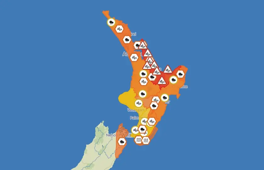
The agency has severe weather advisories in place for the whole of the North Island, and as of 3.30pm states of emergency had been declared for Northland and Waikato including the Coromandel, Hawke's Bay, Whakatāne, Ōpōtiki and western Bay of Plenty.
The Whakatāne District Council this morning issued a mandatory evacuation order for West End Ōhope residents.
The order is for all homes in West End Ōhope, up to and including Beach Point Apartment complex. Residents must evacuate by 5pm today.
"We're not waiting for conditions to worsen - we're acting now while we still have the advantage of time,” Whakatāne's acting mayor Julie Jukes says.
“Protecting lives is our absolute priority. Those in West End, please leave now, while it is safe to do so,” Jukes says.
Local Controller Nicholas Woodley says council staff and police are about to begin door-knocking at the affected properties:
“Don't panic, go early - there is still time to move safely”.
In Hawke's Bay, evacuations in targeted beachfront areas were expected to begin this afternoon.
Coastal erosion was likely, with the most exposed beaches likely to be Mahanga, Haumoana, Te Awanga, Westshore, Kairākau and Pourerere, the district's council said.
The region's incident controller Chris Dolley said people in Haumoana should consider staying with friends or family elsewhere.
Fire and Emergency New Zealand this morning said it was deploying rescue teams with enhanced skills and equipment to Whangārei, Auckland, Rotorua, Tairāwhiti and Coromandel.
Weather alerts
Coromandel Peninsula and Great Barrier Island are under a red strong wind warning and orange heavy rain warning from late this evening, and on Saturday afternoon another red strong wind warning was issued for Bay of Plenty and Rotorua, from 4am on Sunday.
About 2.30pm on Saturday all of the North Island was covered by severe weather alerts, many of them orange heavy rain warnings.
In the South Island, eastern Marlborough - especially between Blenheim and Kaikoura, and about the Richmond Range - is under an orange heavy rain warning for 14 hours from 9am on Sunday.
MetService said there were concerns for power outages, falling trees, flooding, slips and potential road closures that could isolate communities.
The agency urged people to keep up to date with the latest forecasts, adjust plans as needed and be prepared to act, following all advice of local authorities.