MetService said it recorded lows of -6°C in Twizel, St Arnaud and Clyde, and -5°C in Ranfurly and Alexandra early this morning.
But the lowest temperature was -10.3°C at Mt Cook Aerodrome.
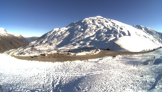
It was a very cold morning in the Queenstown Lakes district, but there were no major road issues to report, a spokeswoman for the council said.
Grit has been applied to some frosty patches on the Crown Range, hit this week by heavy snow. Otherwise, the alpine road linking Queenstown and Wānaka was largely dry with loose grit remaining on the surface.
"This excess grit will be removed today so please drive carefully."
Grit has also been applied as a precaution along Malaghans Road and on frosty patches along Glenorchy Road. A de-icing agent has been applied around Queenstown, Arrowtown and Lake Hayes.
"It's very cold over in the Upper Clutha. The roading crew is reporting temperatures well into the negatives, so rug up Cardrona (-5°C), Wānaka (-6 °C), Albert Town (-5 °C), and Hāwea Flat (-6 °C)."
There was another hard frost in Central Otago with mostly clear skies and the odd patch of fog hanging about this morning, a spokeswoman for the district council said, with temperatures ranging from -1°C to -7°C.
Hard frosts combined with then nice sunny days may cause the top surface of gravel roads in the region to defrost, she warned.
"This is known as freeze-thaw and can make areas of the gravel road slippery. Reduce your speeds in these areas and take care."
Danseys Pass Road is closed (from the gates past the Danseys Pass Hotel), due to snow and ice.
In Canterbury, road users were advised to drive carefully on SH8 Tekapo to Fairlie (Burkes Pass) due to snow and ice this morning.
MetService is predicting more frosty starts over the weekend.
Meteorologist Alwyn Bakker told RNZ today nearly all the South Island's main centres could expect freezing nights "with only Dunedin and Westport remaining above zero for the next few days".
- additional reporting RNZ