

Cardrona Alpine Resort near Wanaka reports that 8cm of snow has fallen and as of 11am it was still falling.
Snow has also settled at The Remarkables skifield near Queenstown.
The Queenstown Lakes District Council has advised that Mt Aspiring Road is closed at Glenfinnan Ford owing to flooding.
The unseasonal snowfall comes amid predictions of heavy rain and strong winds for the centre and south of New Zealand.
MetService forecaster Mmathapelo Makgabutlane said the western South Island, including the Fiordland region, could have 150-250mm of rain throughout today and into tomorrow.
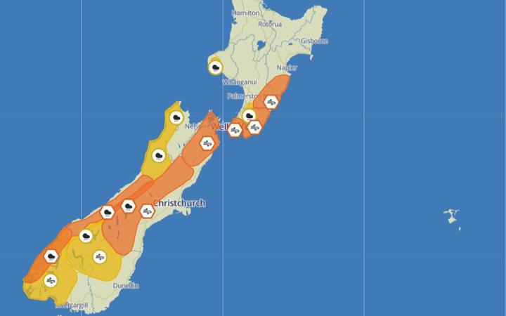
In Westland, thunderstorms may continue during the day along with strong wind and even hail.
Heavy rain warnings are in force for Westland and the headwaters of the Canterbury lakes and rivers, while downpours are expected at the headwaters of the Otago lakes and rivers, Buller, the western ranges of Nelson, the Tararua Range and Mount Taranaki.
Strong wind is forecast in inland Otago, western parts of Southland and the Canterbury High Country, and further north in Marlborough, Wellington, Wairarapa and central Hawke's Bay
Makgabutlane said temperatures in the South Island were starting to fall.
"From today, already we see those temperatures starting to drop over the southern parts of the South Island, and all the way into the southern lakes as well."
Wanaka and Queenstown would reach a maximum of 15C, well below the January average, she said.
"That continues into tomorrow and spreads to other parts of the country as well ... the lower North Island, even into the central parts of the North Island, we see those temperatures only reaching the mid teens into tomorrow. "
"Those cold temperatures continue into Thursday with the first signs of back to average temperatures only coming through by the end of the working week."
A southerly air flow behind a cold front is bringing the cooler air from the Antarctic, with the drop in temperature partly responsible for the thunderstorms.
"Those cool temperatures, especially in the upper atmosphere, cause quite an unstable atmosphere, bringing very favourable conditions for [the] thunderstorm activity."
- additional reporting ODT


