

Residents have been told to avoid non-essential travel, and streets and schools are closed.
Horowhenua District Mayor Bernie Wanden is advising Levin locals to "hunker down" as the area continues to experience severe thunderstorms after a mini-tornado ripped through this morning.
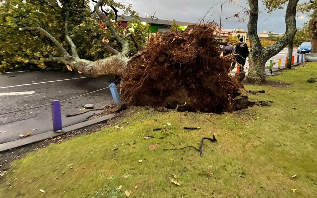
He said the weather chaos had been traumatic for some, as the tornado left a trail of destruction through the west part of the town.
Some roofs had come off, trees were down and there were widespread power outages, Wanden said.
"We're just in the process of trying to restore power, clean up the debris and get things back to normal as quickly as we can."
Two major roads around Levin are blocked after the mini-tornado swept through about 6.30am.
Police said State Highway 1 between Durham St and Supercheap Auto was closed after reports of a strong smell of gas in the area.
Waka Kotahi also reported that SH57 is closed between Tararua Rd and Queen St due to a fallen tree.
Ōtaki MP Terisa Ngobi posted photos of the damage to their property after the tornado.
"The back wall of our office has completely disappeared and trees are down in the main street."
Ngobi is calling on people planning to travel through Levin to avoid it completely as even diversions are starting to cause massive congestion on the roads.
Children who attend local schools are being told to stay home as many of those schools and early childcare facilities are closed as a result.
Donning a hooded rain jacket, she explained the path the tornado had taken and the damage caused just behind, on the road and down the street, as a result.
Workmen could be seen cutting up a large tree blocking the main road.
"Again, the biggest message is to stay home," Ngobi said on a Facebook live video on her official page.
"Please stay safe."
She said her office was "pretty damaged" but that they knew of many local families who were dealing with lots of damage to their properties this morning also.
Motorists are asked to delay travel or to take by alternative routes.
A Civil Defence incident management team is in Levin and are urging people to stay home unless travel is critical.
"The CDEM Incident Management Team has been called in to assist emergency services throughout Levin. Police, Fire and Emergency, St Johns, contractors and arborists have all been activated to assist," said a council spokesperson.
Horowhenua residents report extensive damage to roofs around Ohau. Power is out in the area and a thick layer of hail is covering the ground.
There are reports that roofing iron has blown on to train tracks, and locals are describing the pre-dawn blast as "gnarly".
This comes as Mother Nature is set to unleash a full smorgasbord of weather on New Zealand today, with snow, gales and rain forecast for many parts of the country.
Snow is forecast to fall across much of the South Island as well as parts of the lower and central North Island today and over the weekend.
While temperatures in the upper North Island will stay relatively warm, gale warnings have been issued for Auckland's Hauraki Gulf, Manukau Harbour, Coromandel, Bay of Plenty and Bream Head in Northland to Cape Colville.
It follows a spectacular lightning show over central New Zealand last night, and the stormy conditions continue this morning for the capital.
MetService has issued road snowfall warnings for Crown Range Rd, Milford Rd, Lewis Pass, Arthurs Pass and Desert Rd for the next 24 hours.
Snow is expected to drop to 400m in Southland and Otago, 800m in the Canterbury High Country and 1000m for the central and southern North Island.
"This will be the lowest snow many have seen so far this year," MetService said.
Temperatures have also dropped considerably in the South Island - a high of 12C is expected in Christchurch today, a stark difference from the high of 20C yesterday.
A high of 11C is forecast in Dunedin, 9C in Queenstown and 14C in Nelson.
Most of the North Island has missed the drop in temperatures with a high of 18C expected in Auckland, 16C in Hamilton and 15C in Wellington.
Temperatures at Aoraki/Mt Cook are set to dip to -4C overnight tonight and Saturday.
"We could be paving the way for the first significant snowfall of the year as we round out the week," MetService meteorologist Angus Hines said.
Thunderstorm activity is also expected to continue today after more than 800 lightning strikes were recorded yesterday.
MetService says there is a moderate risk of thunderstorms on the east coast of the main islands this morning as well as in the lower south. The risk continues into this evening.
Large waves forecast
Heavy swells are also expected to hit some parts of the country today.
Boaties near the Foveaux Strait are being warned of high swells, poor visibility and "very rough" seas between Thursday and Saturday, before easing on Sunday.
"Large swell waves and dangerous coastal conditions are expected in the western marine areas of both the North and South Island from Thursday," MetService said.
"Combined waves are forecast to reach 6m for the western South Island later on Friday."


