Foster said he was advised that houses on Breaker Bay Rd between numbers 53 and 194 needed to have residents evacuated today before the situation turned dangerous for residents and emergency services, RNZ reported.
Advice from MetService and NIWA in the past few hours indicated southerly swells of 6 metres or more could present a significant risk to life and property if they overtopped areas alongside the south coast, as they did in April 2020 and in 2013, he said.
Wellington Emergency Management followed that up with an order at 4.30pm for those homes to get out immediately.
An Antarctic blast has descended on much of the country, bringing bitterly cold temperatures, heavy rain, hail and even snow as far as the Bay of Plenty in the North Island.
Exposed coastlines are likely to see overtopping waves causing damage to property, deposition of debris, driftwood, sand and gravel, making access difficult or dangerous and possible road closures, MetService warned today.
The country's coastline is at risk of enormous and dangerous swells, possible flooding and erosion, it said.
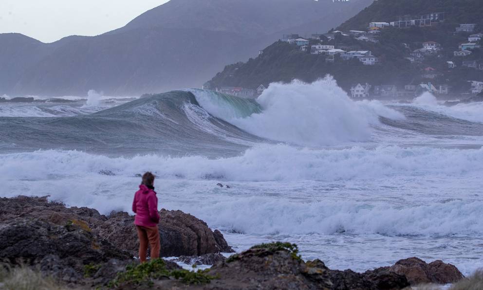
The greatest impact was likely to be on Wellington, with a very present threat to property. Large waves are expected in the inner harbour area, Petone and Eastbourne, but the south coast is set to be hit the hardest.
It was wild at Eastbourne earlier today:
The southerly swell was expected to reach 6 metres on Tuesday evening, with the highest risk period coinciding with high tide at 8.24am and 8.54pm. By Wednesday night, the swell was likely to ease to around 4 metres.
Foster told Newstalk ZB's Heather du Plessis-Allan the sea was "pretty wild" this morning with the swell at about 5.5 metres.
But his main concern was later on tonight at 9pm when waves will reach their strongest. Waves as high as 1.5m could hit dwellings, he said.
Authorities have asked evacuees to see if they can stay with family and friends outside the evacuation zones in the first instance. However, if people are stuck, they can contact Wellington City Council on (04) 499-4444.
Many coastal bus routes and ferries in Wellington are also cancelled as the heavy swell warning remains until 11pm from Baring Head to Sinclair Head.
All passenger sailings on the Interislander today and tomorrow have been cancelled due to continuing bad weather forecast for Cook Strait.
Meanwhile, snow flurries and icy showers peppered the capital's suburbs from Karori through to Broadmeadows, as the bitterly cold polar blast lashed the bottom half of the North Island.
An ice-laced wind straight off the southern continent is sending temperatures in Wellington plunging below zero.
Kayakers rescued
Civil Defence reiterated a warning to stay out of the water after two kayakers feared missing in Wellington harbour were found 22km away after a search was mounted in mountainous seas off Wellington's south coast.
An extensive hunt on sea, land and air was earlier launched for the two men who had been seen in trouble off Wellington's coast at Seatoun. The pair were found safe in Petone.
MetService meteorologist Angus Hines warned today's waves could be damaging to low-lying properties and roads. People in the area are urged to stay out of the water and be prepared to leave their properties if they are at risk.
Heavy snow closes roads
A number of roads throughout New Zealand are closed following heavy snowfall this morning, including the Desert Rd (State Highway 1) and SH2 near Gisborne. Drivers are urged to travel with "extreme caution" due to ice and to delay travel where possible.
A strong wind watch is in place for much of the South Island, including Dunedin, Christchurch and North Otago.
People are advised to wrap up warm and check road closures following a dumping of snow. Flights have been cancelled across Invercargill, Queenstown, Christchurch and Wellington.
Wind chill means single-digit temperatures across much of the country will feel even colder, Metservice warns.
Road snowfall warnings are in place for Napier-Taupo Road, Desert Rd and Remutaka Hill Rd, linking Wellington and Wairarapa. A heavy snow watch is in place for Taihape, the Tararua Range, Canterbury and Marlborough.
- RNZ and NZ Herald