A team of international scientists is preparing to set up two sub-seafloor observatories at New Zealand's largest geological threat: the Hikurangi Subduction Zone.
Scientists believe the large system - which runs from the top of the East Cape to the upper east of the South Island - has the potential to unleash "megathrust" earthquakes larger than magnitude 8.
There was also the threat of large, quick-fire tsunamis that could leave coastal communities just minutes to prepare for: an animation released this week suggested wave heights could reach up to 12m in places.
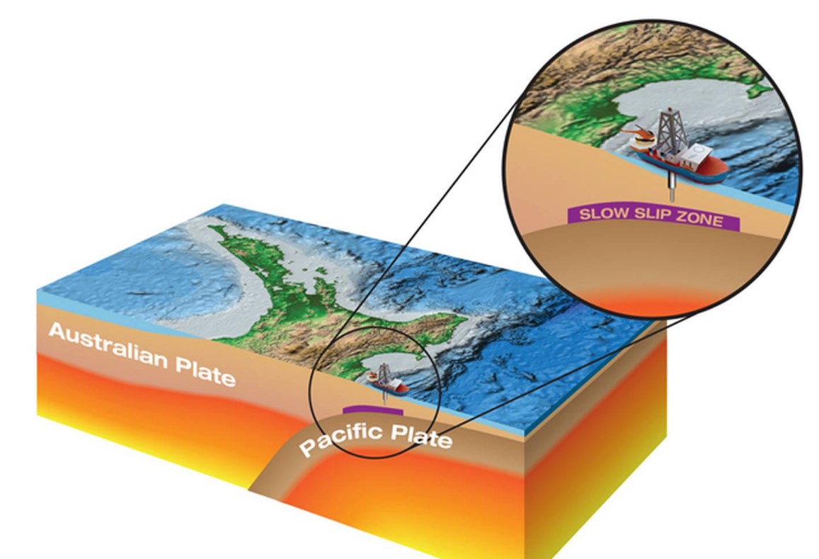
In a new expedition, jointly led by GNS Science and Pennsylvania State University, scientists will set sail for the subduction zone, where the Pacific Plate dives – or subducts – westward beneath the North Island.
Off the coast of Gisborne, the scientific drilling ship JOIDES Resolution will help install two borehole observatories into pre-drilled holes 500m below the seabed.
The project - which has attracted more than $60m in offshore investment, and is funded by the International Ocean Discovery Program (IODP) and the US National Science Foundation - will mark the first time that such observatories have been installed in our waters.
Work kicked off in October, when researchers sprinkled nearly 300 seismometers in a dense array near Gisborne.
Around the same time, two research vessels — the US Marcus Langseth and Niwa research vessel Tangaroa — deployed seismometers on the ocean bottom and blasted sound waves at them to visualise the ocean crust.
Then, in December, the IODP's JOIDES Resolution did some initial drilling at three sites off the coast of Gisborne, to prepare for the bigger expedition that will kick off next week.
The project brings brand new monitoring capability to New Zealand, which may help pave the way for offshore instrumentation needed for earthquake and tsunami early warning systems.
The observatories contain high-tech measuring and monitoring equipment inside their steel casing and will remain under the seafloor for five to 10 years.
But once installed, New Zealand will be only the fourth place in the world to have such observatories.
Similar observatories already operate off the coast of Japan, Costa Rica, and at Cascadia in the Pacific northwest of North America.
This information will also give scientists important new insights into the behaviour of what are called "slow-slip" events - silent, slow-burning earthquakes that can displace faults over days to months - and their relationship to great earthquakes along the subduction plate boundary.
Scientists regard the region east of the North Island as one of the best places in the world to study plate boundary subduction processes, including slow-slip earthquakes.
The sensors will collect data on the how the rocks are strained during what are called slow-slip events, as well as changes in temperature and flow of fluids through the fault zones.
"Slow-slip events or slow-slip earthquakes are similar to earthquakes, because they involve more rapid than normal movement along a fault," explained Dr Laura Wallace, of GNS Science.
"However, during a slow-slip event it takes weeks to months for this fault movement to occur.
"This is very different from an earthquake, where fault movement occurs over a matter of seconds releasing energy suddenly."
Slow-slip events occur at intervals of 12 to 24 months near Gisborne, at a relatively shallow depth beneath the seabed – making this region one of the best places in the world for scientists to study them.
"Slow-slip events are enigmatic because we don't yet understand the physical processes that cause faults to behave in such a way, and we don't know very much about their relationship to large subduction zone earthquakes," said expedition co-leader Dr Demian Saffer, of Pennsylvania State University.
A large slow-slip event was later found to have proceeded the Tohoku 9.1 earthquake and tsunami, which killed nearly 16,000 people when it struck the coast of Japan on March 11, 2011.
2016's Kaikoura earthquake triggered a large slow-slip event off the east coast covering an area of more than 15,000 sq km.
The slow-slip event started in the region of the planned IODP drilling, so the results from this research was expected to shed new light on why this occurred.
Investigating why and where slow-slip events happen was a key missing link in understanding how faults work.
Wallace believed that "slow-slip events also have great potential to improve our ability to forecast earthquakes".
Ultimately, understanding the links between slow-slip events and devastating earthquakes and tsunamis would allow for better risk modelling and ultimately, better hazard preparation for our coastal communities.