PHOTO
A shipload of scientists was meeting in Wellington early today for a briefing before sailing to Antarctica later this week to drill seabed cores on the coast opposite New Zealand and Tasmania.
That drilling off Wilkes Land -- on the edge of East Antarctic Ice Shelf in waters up to 3705m deep --
will investigate links between past climate change and the stability of the Antarctic ice sheets.
Scientists believe a transition from a greenhouse climate, in which Antarctica had forests and dinosaurs, to becoming an ice world took place nearly 33 million years ago, impacting on global sea levels.
By recovering core samples from sediments laid down at that time, they will pin down the timing and nature of the onset of glaciation, and provide a detailed record of the variability of Antarctic climate over millions of years.
The work may also provide clues to the extent to which the glaciation of Antarctica was triggered by dropping levels of carbon dioxide in the atmosphere.
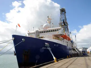
A New Zealand scientist on the Joides Resolution drillship, Rob McKay, of Victoria University's Antarctic Research Centre, told NZPA the ship will next week start drilling up to 1150 meters through the seabed, taking core samples from the coast out to the abyssal plain that makes up much of the floor of the Southern Ocean.
The drill cores will provide information on how the ocean and sea ice changed over time, the extent to which to cover of sea ice helped keep carbon dioxide in the ocean rather than the atmosphere. This may be particularly important if warming due to human activity leads to more sea ice melting.
"It's not simple," he said.
He hoped that a record of the past 36 million years might throw light on the stability of the East Antarctica Ice Sheet.
Dr McKay said it took a long time to find suitable drill sites.
A scientist who works at the University of Granada in Spain, Carlota Escutia, has spent a decade trying to pinpoint the right sites, using seismic testing that mapped the layers on the ocean floor.
Her co-leader on the two month expedition will be Henk Brinkhuis, of Utrecht University, who will also guide work on stability of the Antarctic ice sheets.
Preliminary analysis of the cores will be done on the ship, but most of them will be sent to the Antarctica Marine Geology Research Facility at Florida State University in Tallahassee.
The researchers hope that the cores will allow them to look back to before the continent was covered in ice.
The cores will include sediment dating back 15 million years, when -- recent research suggests -- there was as much carbon dioxide in the atmosphere as there is today.
Dr McKay said there would be potential overlaps with drilling the ship has just done in the Canterbury Basin, and advances and retreats in glaciation seen in other drilling projects, including the big Andrill project carried out by New Zealand drillers on the Ross Sea ice for a multinational consortium.
The Andrill project investigated the West Antarctic Ice Sheet, which is regarded as relatively unstable because parts of it rest below sea level, and would raise sea levels by 4m or 5m if it were to collapse.