A local state of emergency has been declared in Christchurch and Banks Peninsula, to go with an earlier one in Canterbury's Selwyn District, as the region continues to be hit by heavy rain.
Emergency Management Minister Mark Mitchell advised of the declaration shortly after 4pm.
"We can see that they are dealing with a lot of water, but you know the response here is outstanding..." Mitchell said.
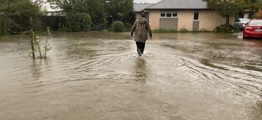
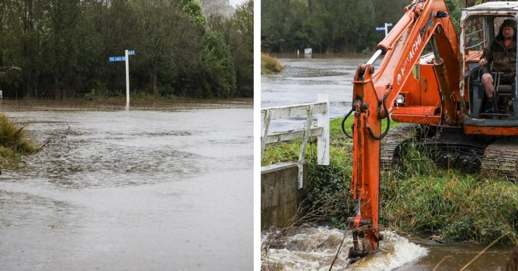
Flooding in parts of Canterbury has led to evacuations in some places, and several motorists have had to be rescued from floodwaters.
Fire officials this evening said crews had been helping people evacuate across the province and pumping water out of homes.
Selwyn District Council says around 40 homes in Doyleston, Leeston, Lincoln, Springston and Tai Tapu have been affected by flooding.
Several houses in Akaroa's Lighthouse Rd have been evacuated because of the threat of a landslip.
The Selwyn District Council this evening urged residents on Old Tai Tapu Rd (south of number 157) to voluntarily evacuate due to a high flooding risk.
In a Facebook post this evening, the council said Emergency Response Teams were on the ground to assist those needing help, and evacuation centres have been opened at Lakeside Soldiers Memorial Hall, Doyleston Hall, and the Lincoln Event Centre.
The council warned of widespread flooding in the Tewhariki Subdivision in Lincoln and urged residents to stay indoors if possible.
It comes as large parts of the country continue to hammered by heavy rain and high winds this evening.
Many weather warnings and watches remain in place for Canterbury, the top of the South Island and lower North Island, and the East Cape.
MetService this evening said its orange heavy rain warning had expired from Amberley north of Christchurch, south to Timaru - including Christchurch and Banks Peninsula.
Meteorologist Lewis Ferris said while it was still wet in the area, the persistent rain experienced in parts, such as Selwyn, has now dropped off.
He said the rain warnings were expected to expire from the south.
North Canterbury remains under a heavy rain warning until 9pm.
Christchurch Mayor Phil Mauger earlier said the state of emergency was due to the impact of the wet weather such as flooding, slips, landslide and falling trees, particularly on Banks Peninsula.
“We expected the weather would ease, which hasn’t happened, so declaring will mean we are prepared for anything that may happen overnight,” the Mayor said.
“The decision to include Christchurch was made as precautionary measure.
"High tide is expected at 7.41pm so declaring means we would have access to powers under the state of emergency if they’re required.”
Rescues
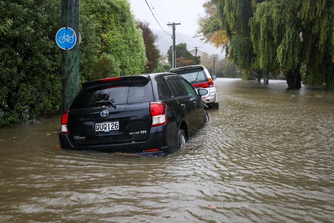
Firefighters today rescued two separate groups of people who had driven around road closure signs in Canterbury and become stuck in floodwaters.
Fenz said two adults and two dogs were rescued from a car that had driven into floodwaters on the Christchurch Akaroa Road.
They were taken to the Little River fire station to warm up and dry out.
Firefighters also had to deal with a vehicle stuck in floodwaters on Avonside Drive in Christchurch. Earlier, a woman and two children were rescued after being trapped in their car amid rising floodwaters in North Canterbury.
This evening they said they had dealt with more than 50 calls for help amid the bad weather.
Little River cut off
Parts of the Banks Peninsula settlement of Little River are under water, with homes and businesses flooded.
Little River - about 30km south of Christchurch - is cut off with the main road awash and rain continuing to fall.
Rob Fowler, who owns an accommodation business in the area, says part of State Highway 75 through the settlement is under more than half a metre of water.
"The rivers are high and the Western Valley Road is not impassable but getting that way.
"Then coming on to the main drag of Little River, you can actually see that it's at least two foot deep down the bottom of the high street - at least," Fowler says.
"Looking at the Post Office, which is up steps to get into, it's nearly up to the window.
"The houses down the bottom of the street will definitely have been flooded. I can see something floating along the road - it looks like an oil barrel."
It is the third time the settlement has flooded since he moved there in 2010, Fowler says.
But the water is almost as high as it has ever been, and it is continuing to rise.
"It's still raining, still blowing a gale and the water is still landing and coming down from the hills," he says.
NZ Transport Agency Waka Kotahi this evening said SH75 would remain closed overnight and at least until Lake Forsyth/Te Roto o Wairewa could be safely opened to the sea.
Checkpoints would be in place overnight.
Dramatic rescue
Earlier, a woman and two children were rescued after being trapped in their car amid rising floodwaters in North Canterbury.
Fire and Emergency New Zealand (Fenz) said the dramatic rescue today showed the perils of swiftly rising flood waters.
Firefighters received an emergency call from the woman trapped with two young children in her car on a bridge over the Cust River at 11.30am today, RNZ reported.
She told them she could not go forward or back because her car was surrounded by water as high as fence posts.
Fenz spokesperson Ian Littlejohn said crews rescued the trio before notifying police and advising the council to shut the road. He urged people to stay off the roads.
A state of emergency was earlier declared in the Selwyn District and several roads have been closed across Christchurch as heavy rain lashes Canterbury. The heavy rain warning remains in place until 6pm today.
In Wellington, a wind warning has been escalated to the highest level - red - until 3am on Friday and includes Wellington City, Lower Hutt, Upper Hutt and Porirua.
MetService said severe gale southwesterlies with damaging gusts of 140kmh would peak this afternoon, especially about the south coast and exposed hilltops.
There was a possibility of "threat to life" from falling trees and other items and there could be significant disruption to transport and power supply. People should stay inside or seek shelter away from trees.
The winds were expected to begin to ease into this evening.
However, it has forced the cancellation of all flights in and out of the capital for the rest of the day. Jetstar and Sounds Air have cancelled all flights for the remainder of the day.
Cook Strait ferry crossings have been cancelled until late on Friday afternoon (Interislander) or Saturday (Bluebridge), due to high swells.
MetService advised the snow had eased, but would still affects some state highways throughout Canterbury today.
Selwyn state of emergency
Selwyn District Mayor Sam Broughton declared a state of emergency at 5.39am today, following 24 hours of heavy rain in the region and the expert advice from the Environment Canterbury flood controller.
Broughton said the rivers continued to rise and there was significant surface flooding, including on roads.
Residents of the Upper Selwyn Huts, where the Selwyn River flows into Lake Ellesmere, were asked to self-evacuate due to concerns of flooding from the river.
“This is a precautionary measure due to potential risk to the residents and their properties. There is an expectation that the community will be cut off, and the river may breach the road and access.”

Resident Scott Rushton told an RNZ reporter at the scene the situation was "the worst I've ever seen. I've been here 10 years but Nick, in the house here, he's been here all his life, he's never seen it like this before."
"The two houses down the back are totally flooded out. It's coming from the high-end, so it just gets coming down heading towards the lake."
The district council distributed 250 sandbags to homes in West Melton, Doyleston and Leeston, while community sandbag stations were set up at centres in Sheffield and Glentunnel on Wednesday night.
"We are encouraging Selwyn residents to conserve water until the supply can be restored. We also ask that you try and minimise water usage in Prebbleton and Lincoln as our wastewater network is becoming overwhelmed, due to the sheer volume of water."
Coes Ford and other fords across the district have closed.
A number of roads were also closed across due to surface flooding. NZ Transport Agency/Waka Kotahi is closely monitoring the Selwyn River State Highway 1 bridge.
Environment Canterbury flood advisory suggests the main impact of the heavy rainfall remains north of the Rakaia. Ashburton District Council road crews were out checking on the state of the network and asking people to take care with widespread surface flooding across the district.
The full extent of damage to the roading network across Canterbury won’t be known until the rain stops and surface water recedes.
MetService meteorologist Mmathapelo Makgabutlane this morning said it had been been a wet night in eastern parts of the South Island, especially Canterbury.
April had been an "extremely interesting" weather month, she said, seeming to pack three months of events into just the four-week period.
"This year has been OK for the Canterbury region, however, this rainfall is falling on extremely sodden ground and I think at any time of year this amount of rainfall would possibly cause issues."
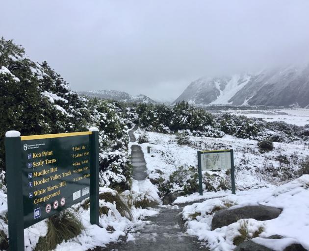
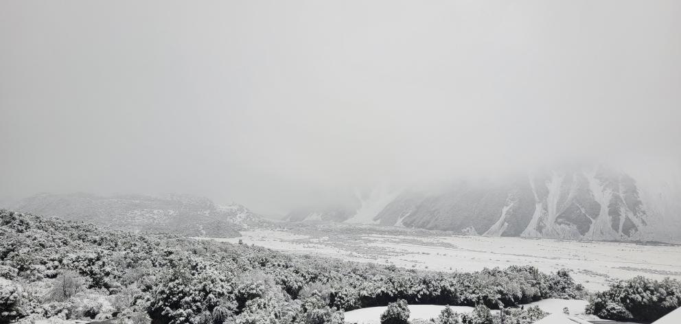
Snow blankets Aoraki/Mt Cook area
Snowfall warnings continue throughout the day for some alpine roads in Canterbury.
It was a winter wonderland at the Hermitage Hotel in Aoraki/Mt Cook National Park, while there was a dusting of snow Coronet Peak ski area near Queenstown.
MetService this evening lifted all its road snow warnings for the South Island's alpine passes.
In Otago, the Danseys Pass Road is restricted to 4WD access only (from the gates past the Danseys Pass Hotel) due to snow.
Strong winds in Wellington, ferries and flights cancelled
A wind warning in Wellington was escalated to red for much of the day, with MetService warning of "destructive" winds that can cause widespread damage.
There is a possibility of "threat to life" from falling trees and other items and could be significant disruption to transport, and power supply, the warning said.
The forecaster downgraded the warning back to orange shortly before 8.30pm.

Sailings cancelled
Interislander Cook Strait ferry crossings have been cancelled until late on Friday afternoon, due to the high swells, while Bluebridge services won't operate until Saturday.
Interislander has cancelled sailings through until 4pm on Friday from Wellington to Picton and 8.50pm from Picton to Wellington.
"All impacted passengers are being contacted directly and we are putting on additional return sailings on Saturday evening and Sunday morning to accommodate impacted customers," the company said this morning.
"We are monitoring the forecasts closely and will advise if further cancellations are required."
Bluebridge has cancelled all its sailings until Saturday morning.
"All customers affected by these cancellations have been advised by email and text. We are monitoring the situation closely and if further sailings are impacted, we will notify you via text and email at the earliest opportunity.
"Additional sailings have been added to our schedule on Saturday to accommodate our affected customers: 1.30pm from Wellington and 7.15pm from Picton."
- reporting by RNZ, ODT Online, Star News and Local Democracy Reporting