
Ferocious winds lashed the South yesterday, downing trees, tearing at roofs and leaving emergency crews scrambling to clear debris from roads.
The wild weather this morning moved north and has been slamming the lower North Island, where a falling tree branch has killed a man, flights were cancelled, multiple fires broke out fanned by wild winds and thousands were without power.
However, any respite in the South looks to be short-lived, as MetService alerts point to more wild winds and heavy rain for the area.
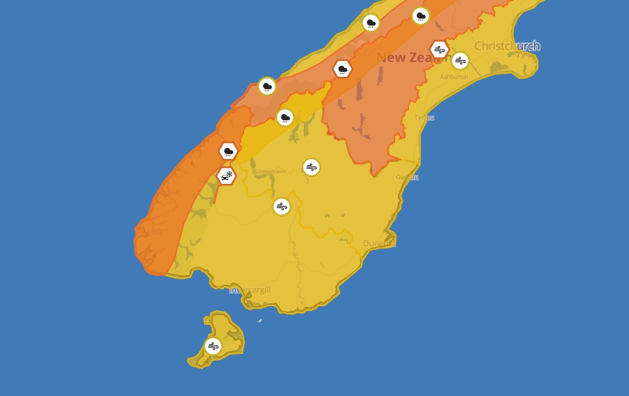
MetService late tonight updated a strong wind watch for Dunedin, Clutha, Southland and Stewart Island from 3am until 4pm on Thursday.
Northwest winds may approach severe gale in exposed places, followed by a change to southwest winds in the afternoon, which may also reach severe gale in exposed places.
In North Otago, Central Otago and the Queenstown Lakes District, northwest winds may approach severe gale in exposed places from 3am until 2pm.
Both watches had a high chance of becoming a warning.
The severe winds could cause damage to trees, powerlines, and unsecured structures. Driving may be difficult, especially for high-sided vehicles and motorcycles. People should prepare their property by securing items that can be picked up by strong winds and drive cautiously.
Heavy rain warning and watches
There is an orange heavy rain warning for Fiordland, from midnight on Wednesday to 2pm on Thursday. Rainfall of up to 200mm is expected, with peak rates of 20 to 30mm/h.
Heavy rain watches have been issued for Westland, away from the ranges, with periods of heavy rain and thunderstorms possible from 12am to 5pm on Thursday.
The Buller and Grey Districts, Nelson Lakes National Park, Spenser Mountains and St Arnaud Range were also likely to get heavy rain from 6am until 6pm on Thursday.
A heavy rain watch is also in place for the headwaters of the Otago lakes and rivers, from midnight on Wednesday to 2pm on Thursday.
Further alerts were in place for most of the rest of the South Island, and for lower areas of the North Island.
Milford Road closed as avalanche threat heightens
Southland's Milford Road (State Highway 94) closed at 5pm today from East Gate (Hollyford) to Donne River (Westgate) due to a heightened risk of avalanche.
The road was expected to reopen about 10am on Wednesday after snow clearing work.
The avalanche risk was moderate today. However, the road was likely to close again at 5pm tomorrow and all day on Thursday as another large weather system forecast would affect conditions, the Milford Road Alliance said.
"The rest of the week into the weekend is also looking unstable."
Effects still felt
The effects of Monday's weather were still being felt in some areas today.
Shortly after midday, NZ Transport Agency Waka Kotahi advised the Anzac Ave in Dunedin was closed to allow the clearing up of tree debris from yesterday. About 1.45pm it advised the road had reopened.
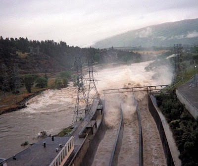
In Central Otago, the Clutha Gold Trail manager advised cyclists to avoid the trail due to the Clutha River level being unusually high.
On social media cyclists were warned there would be water over the trail in places, particularly between Roxburgh and Minzion Burn, south of Millers Flat, as Contact Energy had notified there would be 1300 cumecs flowing from 9.15am today.
It was possible the flow would reach 1500cu m, at which point the Clutha Gold Trail would be impassable, the post advised.
Contact’s head of hydro, Boyd Brinsdon, said heavy rain over the past days as well as snowmelt meant river levels had risen.
He said flows above 1300cu m happened from time to time.
How long the high flows would last depended on the weather. If the rain kept falling, the river could stay high for several day, he said.
Near Wanaka, the Mount Aspiring road has been washed out by flooding.
The Queenstown Lakes District Council said the road was closed at the Treble Cone turn-off while crews worked to repair it.
Further north, Environment Canterbury was closely monitoring the region's alpine rivers, which have a flood warning in place.
Rain has been falling in the headwaters of the Waiau-uha, Hurunui, Waimakariri, Rakaia, Rangitata and Waitaki Rivers, but is easing.
The council said flows have risen in the upper catchments, which will travel through the lower parts of the rivers this morning.
Farmers next to rivers should think about moving stock away from flood-prone areas, it advised.
- Allied Media


