A southerly blast is expected to bring gales and "significant snow" for the south of the South Island tomorrow and on Wednesday.
The MetService has issued a heavy snow watch for the 12 hours from 9pm tomorrow for large parts of Otago and Southland and expects significant accumulations above 400m in some areas.
The warning was in place for Fiordland, inland Southland and Clutha, inland Dunedin, Central Otago and Southern Lakes.
The MetService also has a strong wind watch in place for Coastal Clutha and Dunedin from 7pm tomorrow until 8pm Wednesday and was expecting south to southwesterly gales, which could approach severe gale strength in exposed parts.
Heavy showers were also likely about the southern fiords, Southland and Clutha, where there was a moderate risk of thunderstorms.
These thunderstorms could produce brief heavy rain and small hail, and late in the day heavy snow above about 300m.
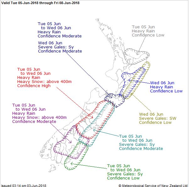
There was a low risk of thunderstorms over the remainder of Fiordland and Otago, also extending into northern Westland, Buller, and coastal Canterbury to about Banks Peninsula at night.
The snow was expected to make travel difficult in some roads and road snowfall warnings were in place for the Lindis Pass, Crown Range and Milford Rd.
Snow showers were expected on the Lindis Pass tomorrow, from 8pm to midnight.
Between 1cm and 3cm of snow is expected to accumulate on the road above 500m.
Further significant snow was likely on Wednesday above 300m.
Snow showers were expected on Crown Range Rd from late tomorrow afternoon to early Wednesday morning.
Between 3cm and 6cm of snow was expected to settle on the road above 500m and lesser amounts to 300m.
Further snow was expected during Wednesday afternoon and evening.
Snow showers are expected on Milford Rd from tomorrow afternoon, between 3pm to midnight.
Between 2cm and 4cm of snow was expected to accumulate on the road near the tunnel, with lesser amounts to 300m.
Further snow was expected during Wednesday.
Ice creating issues today
Meanwhile, road users are advised to take extra care on State Highway 85 from Alexandra to Kyeburn, State Highway 6 from Kingston to Frankton and State Highway 6 from Queenstown to Cromwell because of ice.
Black ice is also causing concerns on State Highway 8 Lindis Pass and State Highway 8 from Omarama to Twizel.
State Highway 1 from Gore to Balclutha was closed due to a crash near the intersection with MacGibbon Rd, but had since been re-opened.
Icy conditions were also expected on State Highway 98 from Dacre to Lorneville, State Highway 94 from Te Anau Downs to Gulliver River Bridge, State Highway 94 from Te Anau to Mossburn and State Highway 96 from Winton to Mataura.
There is also a temporary speed limit of 50kmh on State Highway 96 from Wreys Bush to Dunearn due to slippery surfaces.
The warnings for the South come after flooding, slips and heavy rain have caused havoc on the roads across New Zealand this weekend, with motorists advised to take extra care when heading home from Queen's Birthday holiday destinations.
Northland, Auckland, Coromandel and the Bay of Plenty all fell victim to flooding yesterday, and rain and thunderstorms are continuing throughout the country today.
With NZME


