
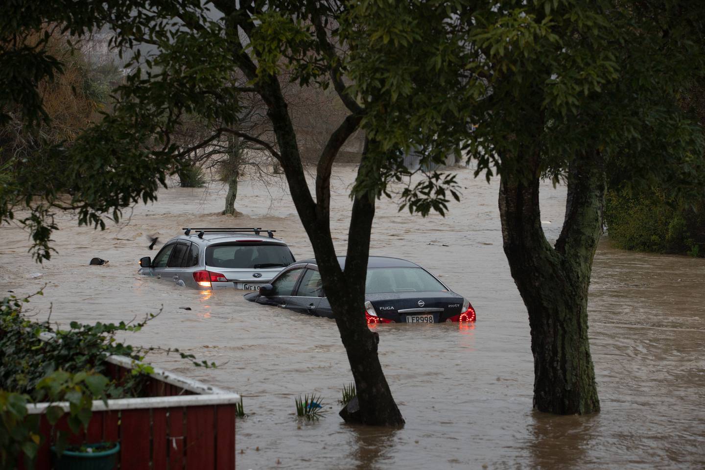
A state of emergency has been declared in Nelson as some residents have been told to evacuate their homes immediately after the Maitai River breached its banks.
More than 220 homes in Nelson have already been evacuated.
Nelson Mayor Rachel Reese said the river, which runs through the city and out to Tasman Bay, breached its banks as heavy rain continues to sweep across the South Island.
Flood waters were this evening encroaching on the city centre, a video from the Collingwood St bridge shows.
Reese called it a one-in-100-year weather event.
Nelson Tasman Civil Defence is urging anyone who lives near the river from the Nile St Bridge to the Golf Course to evacuate.
"Stay with friends and family if you are able," the advice read. "If you have no safe place to go, head to the Saxton Stadium. Take pets, essential medications and warm clothing."
People are also advised to avoid bridges and rivers.
Tasman District Police are advising motorists to limit their travel to essential travel only, as the current severe weather event has closed several roads in the region, and more closures are likely.
Mayor Reese said there are preparations under way to look after people who need to leave their homes and there will be trained people on hand to offer support.
"If people have no safe place to go, they should head to the Saxton Stadium where they will be able to gain assistance."
The rain has caused flooding and slips that are affecting many roads in the region.
The closure of State Highway 6 due to flooding between Havelock and Hira means there is no direct link between Blenheim and Nelson. The alternative route is via SH63 and the Wairau Valley.
As the rain is set to continue, SH6 between Blenheim and Nelson is likely to remain closed until Friday.
MetService meteorologist Ashlee Parkes said the heavy rain was expected to last until Friday, and would persist at this intensity until tomorrow morning at least.
"There might be a slight easing overnight, but it won't be much, what we are seeing now is likely to persist until tomorrow morning."
Over the next 24 hours, the Nelson region is expected to see a further 400mm of rain on top of what has already fallen, which is over double the monthly average.
It won't be until Friday that the region will see any respite, and even then that time will be fleeting as more heavy rain is forecast for the weekend.
"We can't say with certainty if it will be better or worse than today's rain, but they will receive another good dumping."
Earlier this afternoon, a voluntary evacuation order was announced for parts of Westport, Seddonville and Mokihinui.
At a media conference, Buller Emergency Management Controller Al Lawn and Buller Deputy Mayor Sharon Roche said it was a precautionary measure.
Roche said the West Coast was well prepared after several flooding incidents in recent months.
"This is not unusual or new to us."
About 140 households in three areas were being asked to voluntarily evacuate.
Lawn said although the weather event had been slightly downgraded from what was expected, they didn't make the decision to evacuate certain areas lightly.
"It's easier to do it in daylight. The abundance of caution is there. Hopefully nothing happens. I really hope no houses get flooded. No people come home and go 'oh no, not again'."
The heavy rain prompted weather authorities to issue a "red warning" and Civil Defence to declare a State of Emergency for the West Coast.
Westport residents in low-lying areas that flooded in February this year are being advised that they should act today to lift valuables, make arrangements for their pets and be prepared to self-evacuate.
Buller Emergency Management's team said Westport residents in Forbes, Coates and the Gladstone St areas should especially self-evacuate based on updated forecasts and modelling.
"The Buller River is likely to peak in Westport tomorrow morning. As well, the tide will be slightly higher than it was in February," it said on its Facebook page.
"The combination of rainfall, river flows, tide and sea swell increase risk of surface flooding in areas that were affected at that time."
"As a precaution, we ask people to move in daylight to avoid the risk we would have to evacuate them in the dark, placing everyone including our emergency responders at risk."
The area around Franz Josef has seen the heaviest rain. Hydrologists have stayed overnight at the nearby Waiho River to monitor rising levels.
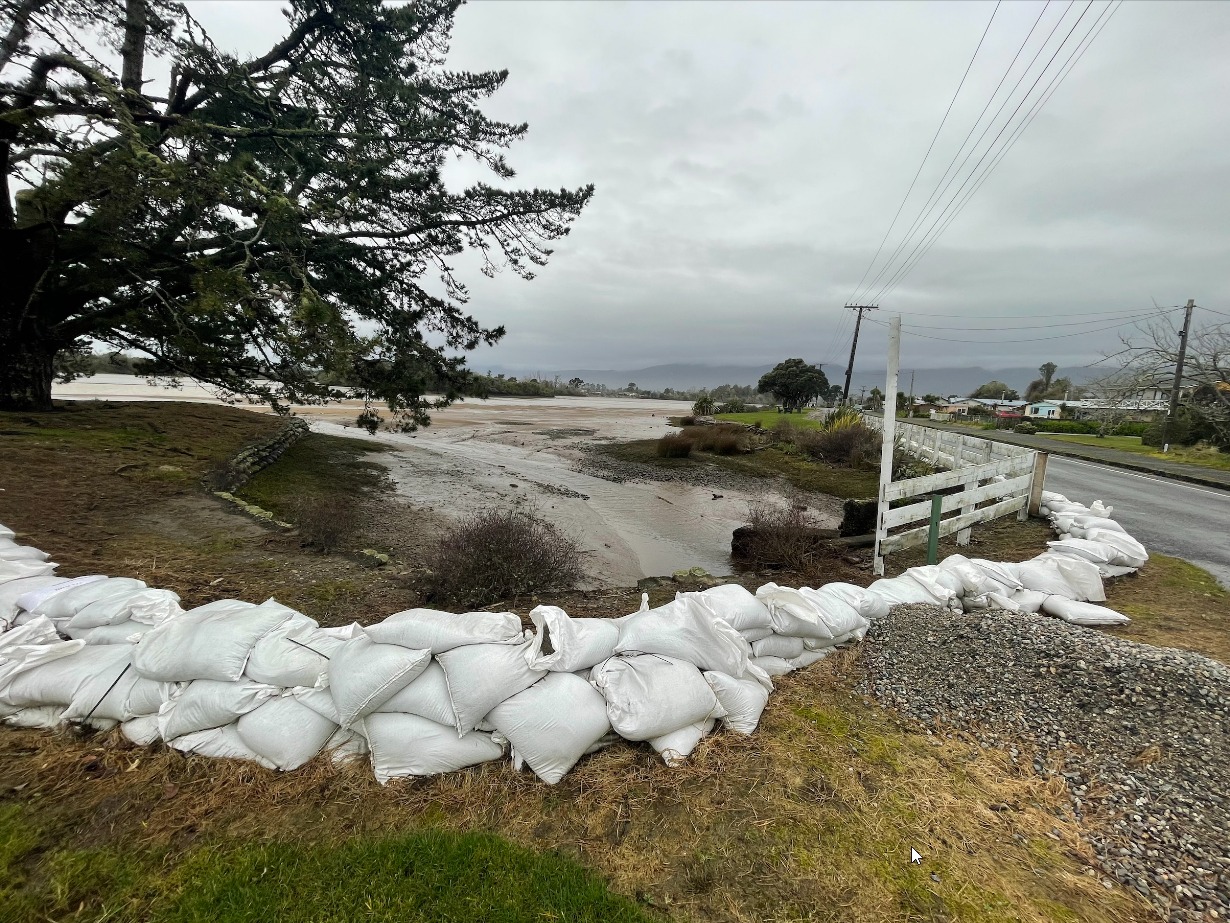
Buller District deputy mayor Sharon Roche told TVNZ's Breakfast programme: "At this stage we're just asking residents to be prepared. A lot of them have already started to sandbag and ... prepare their homes.
"At this stage, there [is] no plan of evacuation. But obviously, if people feel safer by moving out to friends or family to higher ground, then absolutely we would encourage that."
Roche said surprisingly, there was not much rainfall overnight.
"There were times when there were some heavy showers then other times when there was no rain at all."
One advantage authorities had, she said, was time. Extra pumps had been brought in, extra support and had diggers out working in critical spots known to flood in the past.
"We're well prepared - as prepared as we can be."
Roche said they are due to get a briefing and update on the situation this morning.
Asked how residents were feeling, she said: "People are anxious and stressed - there's no doubt about that."
That was particularly the case for those whose homes or properties had been badly damaged in previous weather events, she said.
The West Coast is one of the regions in line for the "atmospheric river" weather event, which one expert says could be more damaging than otherwise as it comes after an exceptionally wet winter.
Atmospheric rivers are large and extremely high plumes of moisture that move in the atmosphere from the tropics to the mid-latitudes, where New Zealand is located.
When they hit another weather event or New Zealand's mountainous terrain, vast amounts of water vapour is squeezed out, falling as heavy rain or snow, Niwa meteorologist Tristan Meyers said.
Experts say it is likely this weather event is influenced by climate change.
Large parts of the rest of the country are also expected to get drenched by the extreme weather event - including Northland, Waikato, Taupō, the Tasman District, Marlborough and Mount Taranaki.
Niwa meteorologist Tristan Meyers said two bursts of rain were expected, from Tuesday-Thursday and then again from Saturday-Sunday, affecting primarily the South Island.
"All up, over a month of rainfall could fall for large parts of the West Coast, Canterbury High Country, Tasman, Marlborough and Nelson.
"This will lead to slips, and possibly flooding for some South Island rivers."
It would also melt snow which could exacerbate riverine flooding in some areas, he said.
Meyers said heavy rain was also headed for parts of the North Island, particularly Northland, Taranaki and Bay of Plenty, with the most intense downfall expected on Wednesday.
University of Otago senior lecturer in geography Dr Daniel Kingston said although this specific weather event had not been analysed regarding the influence of climate change, it was "more than likely playing a role".
Average air temperature had warmed by slightly more than 1degC over the past century and as the atmosphere warmed it could hold more moisture, increasing the likelihood for extreme heavy rainfall events such as this.
"Sea surface temperatures around New Zealand are also warmer than average right now, which can further amplify these sort of events."
Kingston said this event could be more damaging because it comes on top of an already exceptionally wet winter.
July was the wettest on record while more than 40 locations have experienced record or near-record rainfall, he said.
"The ground is already very wet with limited capacity to absorb further rain."
- RNZ and NZ Herald


