


It's a wet week for many parts of New Zealand, particularly the far North where a state of emergency has been declared in Whangerei.
MetService has issued a raft of severe weather advisories as stormy conditions blanket the North Island, and the rain is expected to move on to the South island as well.
The forecaster says a strong and humid easterly flow is bringing the drenching conditions to already-soaked areas.
Auckland is under a heavy rain watch from 9am today until 3am on Thursday. MetService says there's a high chance of it being upgraded to a warning, and periods of heavy rain are expected to increase tomorrow.
Meanwhile, orange heavy rain warnings are in place for Northland for 41 hours and for the Coromandel for 45 hours. MetService says up to 250mm of rain is expected to fall over the Coromandel from today until Thursday morning.
Orange heavy rain warnings are also in place for the Bay of Plenty region, Rotorua and Gisborne from around 12pm tomorrow until 9am on Thursday, with between 180 and 280mm of rain now forecast.
In the South Island, heavy rain watches have been issued for Tasman, Canterbury and Westland between midday tomorrow and Thursday.
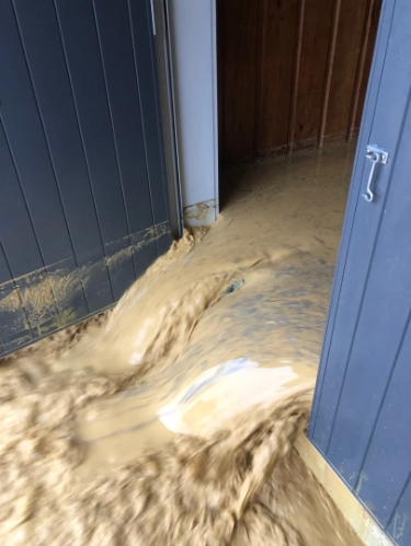
Properties off limits
Three homes in the Whangārei District have been declared dangerous after torrential rain battered the east coast around Ōakura on Sunday.
Whangārei mayor Ken Couper told RNZ the three properties now off-limits to their owners were among seven flood-damaged homes inspected so far.

The latest damage toll comes as five marae and a community hall open their doors to more potential evacuees as Northland's east coast prepares for a second hammering.
On top of the heavy rain forecast through to 2am on Thursday, large swells could worsen coastal damage and flooding if they coincide with high tides.
Couper said places that had been subjected to heavy rainfall since Sunday were especially vulnerable, because the ground was already sodden and unable to soak up any more rain.
He said a Civil Defence team was meeting community members and carrying out welfare checks today in the worst-affected areas around Ōakura.
He had also visited the area this morning to see the damage first-hand.
With strong winds expected to return, it was likely more trees would come down, causing power cuts and obstructing roads.
Couper urged residents to stock up with supplies if needed, get a "grab bag" ready with a phone, medicines and any other essential supplies, and to ensure that batteries were fully charged.
He said anyone with a holiday home in the affected area should put off visiting until the storm had passed through.
RNZ/Allied Media


