A cluster of sharp aftershocks rattled people around the country on Monday evening, including three "severe" quakes near Seddon and another near Kaikoura - the largest a magnitude 5.8.
The latest aftershock, a magnitude 5.8, hit at 8.21pm, at a depth of 15km, to the south east of Seddon, according to GeoNet at 8.21pm
This followed just one minute after a 5.8 quake, 25km to the southeast of the township, which hit at a depth of 15km. at 8.20pm
The duo followed a smaller magnitude 5.6 quake hit, 20km also to the east of Seddon, at a depth of 23km at 7.43pm.
Another followed less than five minutes later, this one a magnitude 5.7, but was only classed as "strong" in intensity, as it was almost twice as deep, 40km below ground and 25km to the east of Kaikoura.
Thousands from as far south as Canterbury and as far north as Auckland have reported feeling the sharp jolts.
The aftershocks are amongst the strongest felt since the larger quake woke thousands from their slumber, led to a tsunami alert and a widespread evacuation notice along the east coast and damaged thousands of homes.
Help arrived yesterday afternoon for Kaikoura residents and travellers hit hard by the deadly 7.5 event, which GeoNet now considers two separate earthquakes, with military choppers ferrying people and resources to the town.
The original quakes struck at 12.02am near Hanmer Springs in North Canterbury and were felt throughout New Zealand. They triggered a tsunami alert down the length of the east coast but this had been lifted. However, people were urged to stay safe and away from the coastline as more strong aftershocks could be expected.
A slip blocking the Clarence River near Kaikoura breached about 4.20pm and a large wall of water flowed downstream. The water was 15m high when it built up at the dammed-up debris in the river.
Police and ground crew evacuated at-risk residents.
A 100-year-old woman and her daughter-in-law were rescued from the rubble of a Kaikoura homestead flattened by the powerful quakes, kiling one man. A second person died of a heart attack at a property in Mt Lyford and there were reports of several people suffering non-fatal heart attacks.
Pam and Louis Edgar lived at the large property with Mr Edgar's mother, Margaret. The building collapsed on Monday morning and rescuers spent hours searching for the trio. A Fire Service spokesman said one of the women was able to escape, while the other had to be rescued. Mr Edgar did not survive.
Meanwhile, structural engineers were checking buildings in Kaikoura later on Monday and military choppers were ferrying people and resources to the town.
A welfare centre was set up at Kaikoura marae about 5pm.
Power was gradually being restored in Kaikoura, but sewerage systems and water supplies were still down and it could be a while before they were back up and running, Civil Defence said.
Power, communications, sewerage and water were all cut off by the colossal earthquake.
There was still no way in or out of the town by land. Emergency services from Nelson and Christchurch were airlifted in to help local response teams.
Civil Defence was considering using private bores to supply water and urged residents to conserve water.
Shops were closed and locals could not buy food, fuel or water this afternoon.
TRAVELLERS RESCUED
About 1000 tourists were in the town, Civil Defence said.
Police were rescuing travellers trapped in the town's northern and southern outskirts.
The occupants of at least six campervans in Kaikoura's north would be airlifted to the Ward Welfare Centre and the people stranded just south of the town would be flown further south, Civil Defence said.
A Fire Service spokesman said a six-strong urban search and rescue squad were sent from Christchurch.
The team touched down in Kaikoura around noon, but no further information was available because communications were poor, he said.
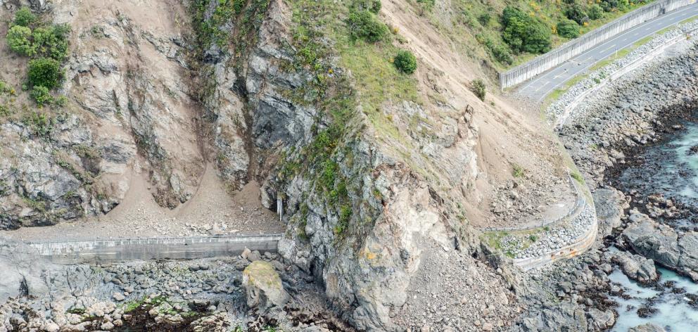
State Highway 1 will remain closed to the north and south of Kaikoura until further notice after massive rockfalls.

Transport Agency (NZTA) highway manager Neil Walker said the damage to the road would be assessed when the areas could be safely visited. Poor weather and the possibility of strong aftershocks were causing concern.
The agency was working with Kaikoura District Council to open the old inland SH70 route between Culverden and Kaikoura within the next few days, Walker said.
Staff and contractors were also liaising with KiwiRail, police and local emergency crews to get people out of cut-off areas as quickly as possible.
CAPITAL HIT
"It was the most significant shock I can remember in Wellington," Prime Minister John Key told reporters at a dawn news conference from the parliament's underground bunker in the capital city.
"There will be quite major costs around roads and infrastructure."
Civil Defence declared a state of emergency for the Kaikoura region soon after Monday's large aftershock. A tsunami warning that led to mass evacuations after the original quake was downgraded after large swells hit Wellington, in the North Island, and Christchurch. There were no new tsunami warnings issued after the 6.2 aftershock
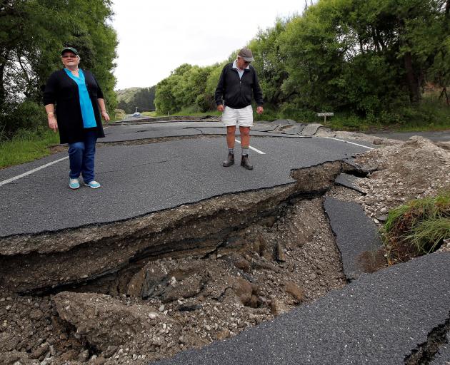
Kevin Heays, of Environment Canterbury in Kaikoura, told RNZ there had been a lot of damage to roads. "There are a lot of poles down. I'd say we will be without power for a long, long time. I understand that the roads north and south are out so we are pretty well isolated."
Acting Civil Defence minister Gerry Brownlee said the quake had been felt "extensively". "There will be a lot of people out there very unnerved by this. The sort of holding hand you can put out to anyone who is distressed would be very welcome."
New Zealand lies in the seismically active "Ring of Fire", a 40,000km arc of volcanoes and oceanic trenches that partly encircles the Pacific Ocean. About 90% of the world's quakes occur within this region.

DAMAGE TO ROADS
There were many sites affected on State Highways 1 and 7, on both sides of Kaikoura, and inland from Waipara to the Hanmer Springs turnoff and to Springs Junction (State Highway 7, the Lewis Pass route) - some more extensively damaged than others, the New Zealand Transport Agency advised.
State Highway 1, Picton to Blenheim/Seddon was now open but Seddon to Cheviot remained closed. Cheviot to Christchurch is open, NZTA highway manager Neil Walker said.
State Highway 7 would open on Monday night as an alternative route for traffic to travel north to Blenheim and would be down to a single lane in places and take about three hours, he said.
“People need factor in a longer journey time into their travel plans and ensure that they have plenty of fuel, warm clothes, food and water.”
To enable access to Kaikoura, NZTA was working with Kaikoura District Council to open the inland road (old SH70) between Culverden and Kaikoura within days.
State Highway 7A, giving access to Hanmer Springs from State Highway 7, would be open for three hours from about 5pm today for light vehicles only, and under escort by contractors. It will be closed overnight due to the risk of further rock falls. This route would open again at 7am tomorrow morning under the same conditions.
The current sections of state highways are closed:
State Highway 1 - Seddon to Cheviot
State Highway 7 - Waipara to Springs Junction
State Highway 7 A - Springs Junction to Hanmer Springs
People can call 0800 44 44 49 for updates and the NZTA's website and social media accounts will be also updated as more information is available. South Island updates: www.facebook.com/nztasouthisland


