
The MetService has issued a string of weather watches and warnings for across the South Island ahead of a front tomorrow.
Before tomorrow's front hits there is a risk of thunderstorms this afternoon and evening.
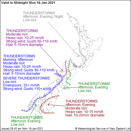
In Otago, parts of inland Southland and South Canterbury there is a moderate risk of thunderstorms, which could bring heavy rain of up to 10mm to 15mm an hour and hail 10mm to 20mm in diameter.
Meanwhile, on Tuesday it is expected to become increasingly unstable in the morning as another front moves northwards over the South Island, followed by a disturbed westerly flow.
The risk of thunderstorms continues for much of the South Island tomorrow with a high risk in Fiordland and small tornadoes possible in Westland.
Watches and warnings in place for tomorrow cover large parts of the island, but the worst is expected to miss the east coast where none are in place.
A heavy rain watch is in place for Fiordland from 3am to 11am and the headwaters of Otago Lakes and rivers from 6am to 9pm.
A strong wind watch is place for Southern Lakes, Central Otago and inland Dunedin from 5am to 8pm and Fiordland and Southland west of Invercargill from 3am to 8pm.
Heavy rain warnings are in place for parts of the West Coast and headwaters of Canterbury Lakes and rivers, while a heavy wind warning is in place for the Canterbury High Country.


