

After more than seven years of hard work, Wenita Forest Products Ltd has opened 12 public tracks throughout and near its forest plantations in Berwick, Mt Allan and on the coast.
‘‘People sometimes think forestry is just burly men in checked shirts running around with chainsaws.
‘‘But in fact, it’s a sophisticated and responsible operation, and supporting public access allows people to see that for themselves,’’ Wenita chief executive David Cormack said.
The process of creating the tracks began in late 2018, when the Overseas Investment Office (OIO) granted Otago Estate Limited (OEL) permission to acquire more than 22,000ha, covered in exotic forestry, owned by Wenita, near Dunedin.
OEL was controlled by New Forests Australia Forest Fund 2, of Sydney, a long-term forestry investment fund.

In late 2025, OEL was sold to APG Asset Management — Europe’s largest pension investor — along with a 38% stake of Wenita’s owner Taieri Forests Limited (TFL).
TFL is now jointly owned by APG and the Pension Protection Fund, based in the United Kingdom.
In 2018, the Outdoor Access Commission had a statutory role in assessing OIO applications with a view to protecting and enhancing public access.
While the forests were already crossed by public roads, opportunities were identified to create new walkways and access to the forest and historical sites including from early gold mining and farming days.
The OIO agreed to these access routes as conditions for the consent.
That led to seven years of work to get the routes ready.
For safety reasons, since the walkways are within working forests, access is by permit.
Last year, the company granted more than 3500 permits, mainly to hunters.
Mr Cormack said completing the project was a relief, but the best thing had been seeing people enjoying the benefits.
The company did not reveal the total cost of buildings the tracks.
‘‘Wenita forests are a very popular place to spend time, and so far, we have had only positive feedback — so that’s the proof of the pudding, for me.’’
The new walkways range from a few hundred metres to 15km in length and from gravelled, driveable forestry roads through to steep walking tracks.
Most are through exotic forest, but
there are pockets of mature native trees and birdlife.
About 3200ha of the forest area is cloaked in indigenous vegetation, managed for conservation purposes and some easements run through or around these areas.
The forests were also home to a growing population of the nationally threatened kārearea, New Zealand falcon, as well as at-risk native galaxiid fish, Mr Cormack said.
‘‘Our creeks do sustain life and hence it’s important to work around them and not damage them.’’
Most public access routes are for walking or cycling only.
Information passed on by visitors could help Wenita manage the forest, Mr Cormack said.
Mr Cormack said the main advice he would share with other landowners, especially forestry owners, considering allowing public access was ‘‘don’t fear it’’.
‘‘There are certainly benefits to having people in your forests.
‘‘But go in with your eyes open.
‘‘It can be a complicated process — it can be expensive.
‘‘But, in our experience, the benefits have outweighed the disadvantages.’’
More broadly, people now expected to know what was going on in forests and on farms, he said.
‘‘We need to give people the opportunity to see with their own eyes how we’re treating and leaving the land, how we’re operating on it.
‘‘If you’re not prepared to do that, someone else will fill them in for you. And it won’t always be favourable.’’

The 12 new public access routes in Wenita’s forests
For safety reasons a permit is needed to visit the tracks.
Berwick Forest
Peerie Rd water race track
The remnants of an old water race are marked on Rosemur Rd. The round-trip distance is 22 km. The track section is grade 4 riding and given the distance from the locked gate, the best option is by bike.
Browns Cottage and Wetlands Loop Track
Follow Glenburnie Rd for 5.8km to a historic cottage from the farming era. The cottage area is a good spot for a picnic, but the cottage should not be entered. There is a 1.2km Wetlands Loop Track (walking only) around an area of protected sub-alpine vegetation. Frosty conditions create a microclimate which supports plants usually found at much higher elevations.
Mahinerangi Track
This is the second half of the Mahinerangi walkway and is accessed via Doc’s Government track. Enter Wenita’s forest and continue a further 4.5km on forestry roads before the very pleasant walking/riding section around Lake Mahinerangi to Post Office Creek.
This trail follows old mining water races just above the lakeshore to some derelict historic buildings.
Halfway Rd Reserve Track
Walk to the Halfway Bush covenant area. There are two marked loops within the native forest, each about 400m long. The mature podocarp forest remnant was protected by covenant in 2023.
Berwick-Waipori Track OYATI (Otago Youth Adventure Trust)
Original New Zealand Forest Service track linking the old Otago Youth Adventure Trust HQ area to the Waipori Gorge.
OYATI old HQ section
This track uses some of the old Forest Service track through plantings of various tree species that have since been harvested. A pleasant walk to the OYATI lodge.
OYATI Track
Starts at the OYATI Lodge and follows the road 500m to the OYATI pond. There are two walking options: the shorter, easier loop around the pond is about 500m, while the second heads upstream through manuka and regenerating native forest, adding about 1.1km.
Mt Allan Forest
Long Ridge Track
This walking track along Wenita’s boundary links the Pulpit Rock area to Powder Ridge.
Mt Allan access
From a large parking area near the Taieri Gorge Railway line, head steeply up Mt Allan Rd to the north. The Mt Allan route to Doc’s Silverpeaks Reserve is 14.5km. A gravel or mountainbike is the best way to travel.
Poplar Hut can be accessed via Mt John Rd but it is not available as accommodation.
Mt Allan Rd is accessible until the end (9km) but does not offer access to the Taieri River.
Wingatui Viaduct access
From a large parking area near the Taieri Gorge railway line there is access down to the Wingatui Viaduct (550m) and the Taieri River (1.75km).
Otago Coast Forest
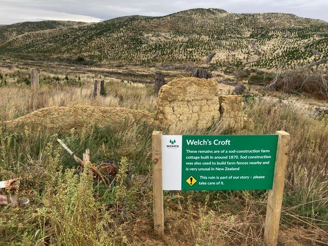
Welch’s Croft Track — Allanton Block
The remains of Welch’s Croft, an historic sod-construction cottage can be accessed from a locked gate on Taieri Mouth Rd.
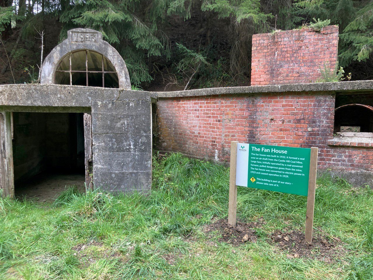
Castle Hill Mine House Track — Kaitangata Block
A very easy walk of 750m from Needles St to the historic Castle Hill Coal Mine fan house, completed in 1923.
A fan house sits over a coal mine air shaft and uses large fans to draw out gases. The fans are gone now, but the intriguing building remains. Access to the building is not permitted.


