PHOTO
Roads are closed and surface flooding has been reported on the West Coast as a major front dumps "significant" amounts of rain on the region.
The heavy rain and severe gales hitting parts of Otago, Southland and the West Coast are expected to continue into tomorrow.
Grey District Council (GDC) notified residents this afternoon of surface flooding on State Highway 6 between Coal Creek and McLeans Pit Rd.
"They are trying to keep the road open for as long as possible to let people get home but it is expected to close around 5pm."
At about 10am a motorist had a close call on Taylorville Rd when a slip brought trees and earth down, narrowly missing their vehicle.
The car ended up straddling a fallen beech tree and the driver, understood to be a local woman, was unhurt but shaken.
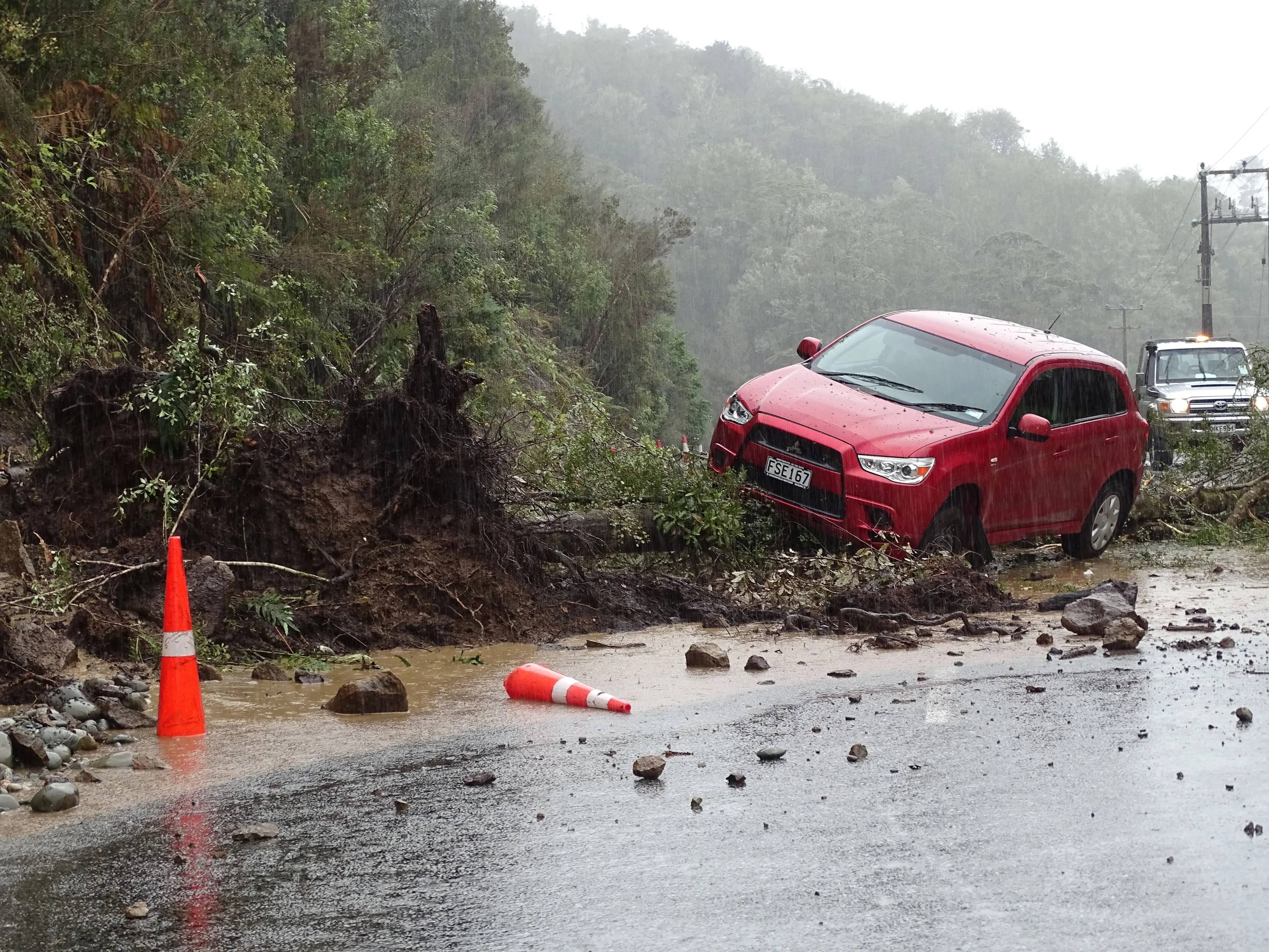
Taylorville Rd east from the township Taylorville to the turnoff at Blackball Rd was closed shortly afterwards.
The slip first moved in late April during a weather bomb and has been periodically dropping more debris since.
The alternative route along State Highway 7 Greymouth to Stillwater through Dobson remains open.
Te Kinga Crossing on Cashmere Bay Rd has also closed though gates over the rail crossing remain open for essential travel only. The crossing is without signals or controls so GDC is urging people to be extra cautious of trains.
Surface flooding has been reported at Mine Creek, Lake Brunner Rd and in patches across the wider district.
Civil Defence has been keeping a watchful eye on river levels ahead of high tide, which is due shortly before 7pm tonight.
South Westland Area School was closed today as a precaution.
A MetService spokesman said earlier the front, preceded by strong and moist northerly winds, was expected to hit the South Island from the west today, then move slowly northeastward during tomorrow.
"The front is forecast to deliver heavy rain to the west of the South Island, including the headwaters of the Otago and Canterbury lakes and rivers.
"Severe gale north to northwesterlies are forecast about the Canterbury High Country, Fiordland, and western parts of Otago and Southland.
"Warnings and watches for heavy rain and severe gales are in force for these areas."
He said the amount of rain forecast for central parts of Westland, in particular, was "significant".
"Dangerous river conditions and flooding are possible, with the potential for slips and floodwaters to make some roads impassable.
"An Orange warning for heavy rain is currently in place for Westland, but may be upgraded to a Red warning closer to the time.
He said Westland and the headwaters of the Canterbury lakes and rivers south of Arthurs Pass could expect up to 550mm of rain between this morning and 9am tomorrow, with peak rates of up to 35mm per hour or more today.
The headwaters of the Otago lakes and rivers could expect up to 150mm of rain about the divide, and up to 100mm within 25km east of the divide.
Peak rates of up to 30mm per hour were expected before dawn today and heavy rain may return later today.
Strong winds gusting up to 140kmh are also expected for the Canterbury High Country, he said.
"Strong wind gusts could damage trees, powerlines and unsecured structures.
"Driving may be hazardous, especially for high-sided vehicles and motorcycles."
He said it was possible the weather warnings would still be in place on Friday for Westland, and extended to all of Fiordland and Stewart Island.
"A cooler southwest change is expected on Friday.
"This may bring some snow to the higher roads of the southern South Island, but it is unlikely that snow warnings will be issued.
"However, [it is possible] that strong west to southwest winds associated with the change will require a warning for Stewart Island and parts of coastal Southland and Clutha on Friday and early Saturday."
A large high was expected to move on to the country during Saturday and Sunday, bringing easing conditions, he said.
- Additional reporting Greymouth Star/RNZ