
They circle, round and round the spherical stones scattered across the golden sand.
As they do, they no doubt wonder aloud or to themselves "How on earth? What could possibly account for these marvels?".
Perhaps some share the information they’ve gleaned from their phones, but they’d have done better to have loitered back at the Moeraki Boulders Cafe. Because here, on an outside area overlooking the scene, Te Rūnanga o Moeraki upoko David Higgins is telling the story.
The TikTok edit is that the beachgoers have encountered Te Kaihīnaki — and on that basis there might well have been scavenging to do, if only they’d arrived some centuries earlier.
But we are getting ahead of ourselves. We need to back up the waka just a little and let the kaihautū (skipper) do the steering.
"Ko Te Kohurau te mauka, ko Kākaunui te awa, ko Moeraki te tūrakawaewae," Higgins begins.
Te Kohurau is his mountain, the Kākaunui is his river and Moeraki is his home, his place to stand.
This is a very abbreviated version of Higgins’ pepeha. His extensive connections up and down this coast, Te Tai o Āraiteuru, retell a history of occupation.
We might insert here one further detail — among Higgins’ tupuna (ancestors) is the rakatira Rāwiri Te Mamaru, a noted keeper of the region’s history.
"Nō Moeraki ahau," Higgins says, wrapping up his introduction. He’s from Moeraki.
The common thread weaving its way through all of this, those mysterious stones, Higgins’ pepeha, Moeraki and this stretch of coast is a waka.
And it’s in the cargo of that waka that those beach visitors below, in their colourful holiday jackets, will find some of the answers they are looking for.
The waka is Āraiteuru, one of the great double-hulled, ocean-going voyaging craft upon which Aotearoa and Te Waipounamu’s earliest inhabitants travelled to and from the Polynesian homeland.
Higgins sets the story’s sail again, and the tauihu (prow) of the waka sets its sights on a land mass 4000km distant.
"The waka atua Āraiteuru and her sister waka, Mānuka, were due to depart Taputapuātea at Raiatea in the Tahitian archipelago in the northern Pacific," Higgins says, drawing from a narrative as familiar to him as if it were yesterday.
"Their task was for the crew to arrive back here in Aotearoa me (and) Te Waipounamu with enough seeds and plants to ensure that when humans arrived in this land that they were able to sustain themselves by utilising these different vegetables."
Critically important among this precious cargo were the staples taro and kūmara.
"As the waka left, Āraiteuru led out of Raiatea and Mānuka followed. Unfortunately, the karakia that the crew on Mānuka used for the journey was not appropriate and all of their product spoiled on the journey across the Great Ocean of Kiwa."
It would not be an epic if everything went to plan.
However, the karakia recited aboard Āraiteuru did their work and the waka duly arrived on the tail of Te Ika-a-Māui, the North Island.
There, in Te Tai Tokerau, the crew disembarked and planted a māra kai, a food garden, of both taro and kūmara, Higgins says.
"They then journeyed further south to a place called Tūraka, which is Poverty Bay, and at Muriwai on the southern shores of Tūraka, or Tūranga, they planted another māra kai of kūmara and taro. Those māra kai are still there today and are cared for by those different whānau and hapū of that particular area."
But the waka’s journeying was not done yet.
"The waka then continued down to Te Waipounamu and to the Kaikōura coast [Te Tai-o-Marokura] and stopped at the southern end of the Kaikōura Bay at a place called Oaro, where our Kati Kuri people now reside and again planting took place there at Kaikōura. Those māra kai at Kaikōura are still there today and the kūmara still thrive."
There were further stops at Ōmihi and Hamuri.
By this stage, the waka atua had covered a vast stretch of ocean and the toll the voyage had taken was beginning to show.
"As the waka travelled further south, it got to just off the North Otago coast at Waitaki and the waka started to settle lower in the water, so there was very little freeboard left."
A rogue wave washed one of the passengers overboard and she drowned. Her name is today attached to a rock at the river mouth, Moko Tere a Tārehu.
"The atua on the waka travelled further south, past Moeraki, where we stand today, and arrived at a place called Taki Te Uru, which is what is described today as Danger Reef, off Matakaea or Shag Point, just south of the Kātiki Bay. It was there that a wave overtook the vessel and the waka was turned over, founded, and ended up on the rocks at Matakaea. The waka eventually turned to stone and remains there to this day as a rocky outcrop, which signifies the upturned waka, Āraiteuru."

The remainder of the crew, who were all atua, Te Kohurau and Aoraki among them, made it to shore and began to explore the land — extraordinary in its vastness for travellers from small Pacific islands.
As the crew gathered firewood and other materials, some were overtaken by the dawn and, unable to recite the appropriate karakia in time, were turned to stone.
"They became particular outcrops of land, peninsulas, mountains and rivers. Their names are embedded in those places today."
Puketapu, which stands above Palmerston, and Pakihiwitahi near Matakaea are two such places.
Of those who ventured inland, perhaps the most celebrated are Aoraki (Mt Cook) and his grandfather, Kirikirikatata (Mt Wakefield), who went in search of their fellow crew members, Higgins says.
Aoraki now rests on the shoulders of his pōua (grandfather), surrounded by his siblings and cousins, who form Kā Tiritiri-o-te-moana (the Southern Alps).
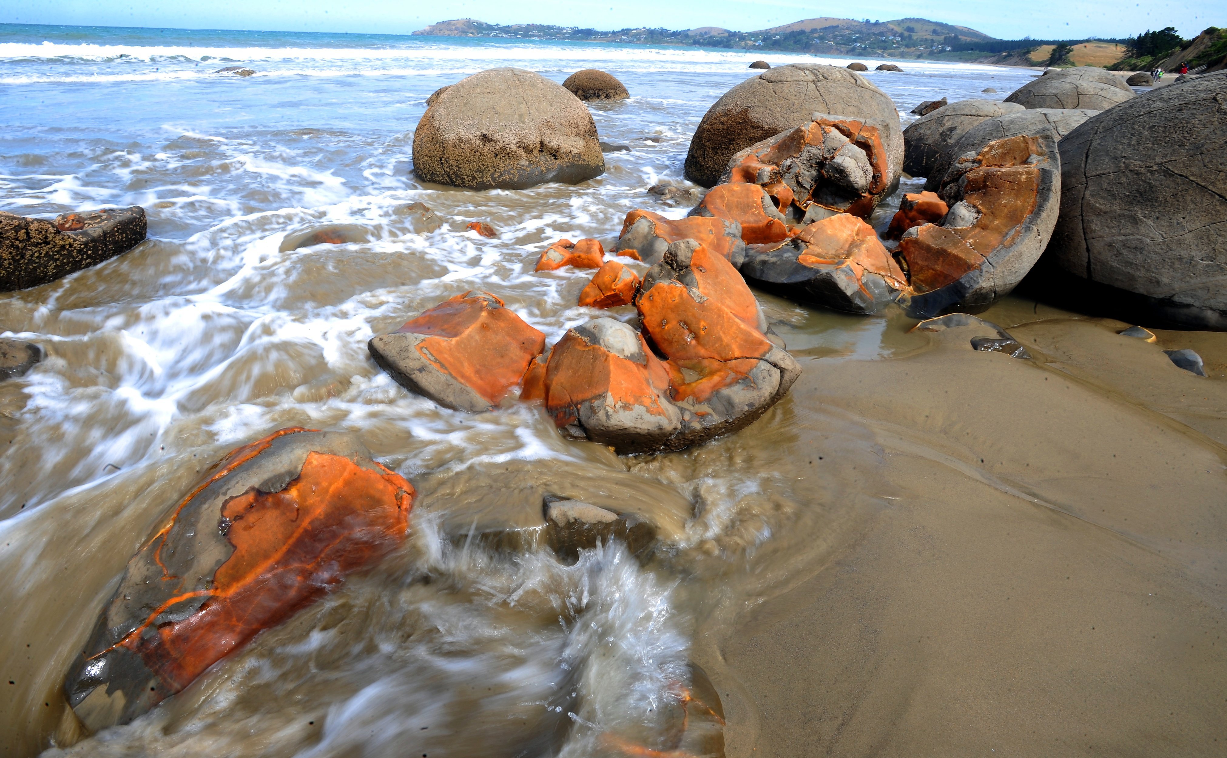
But what of those mysterious stones, the boulders marvelled at by so many tourists?
The boulders, Higgins says, are commonly misnamed, as they are not in fact at Moeraki. Rather, they lie on Koekohe beach, between Moeraki and Kurinui (Hampden), and are more properly referred to as Te Kaihīnaki.
Te Kaihīnaki literally means "the food baskets", he explains.
"Those boulders represent some of the cargo that was on that waka, which included food baskets, gourds and calabashes.
"The smaller boulders, found at Whataparaerae at the southern end of Kātiki Beach — which range from the size of a tennis ball up to larger than a basketball — represent the kūmara themselves, and the golden sand from Moeraki beaches represents the seed of the tubers."

Atua aboard the waka named various features of the landscape to further establish a sense of belonging, Higgins says.
"Now, remember that this is only one of a number of different creation stories linked to this particular waka atua," he notes. "But this is the Moeraki version.
"The fact that we have these wonderful and beautiful names throughout the island, particularly off this coast and further inland, is because we remember to remember our history and traditions."
The remembering has taken on a renewed focus in more recent times, as European names have been laid over many of the same natural features.
They don’t link very well or very kindly to the traditions and histories of mana whenua, Higgins says.
"If you travel south from Moeraki, you get to just north of Palmerston. And there’s a river there they call the Shag River.
"I don’t know why they call it the Shag River, but its real name is Waihemo. And it’s a beautiful name, that name itself means a lot of things to us, and it’s part of our Āraiteuru story."
For all these reasons, the hapū and iwi of Te Tai o Āraiteuru ensure their names are shared from one generation to the next, to their rakatahi (young people), their tamariki and mokopuna — so they can understand who they are and where they come from, he says.
Indeed, for some of the uri, the descendants of the waka, embracing that heritage has involved travelling back to Raiatea to experience for themselves where it all began.
"They’ve travelled to Taputapuātea to visit the old place where those waka left from. And those traditions are as well known over there in the Tahitian Islands or far distant Hawaiki as they are here.
"We share the same whakapapa. Interestingly enough, as you leave Raiatea in a waka, on the left, the hill as you leave is Aolaki, and the other hill on the starboard side is Moelaki."
"I started fishing here in 1968 and some of the fishing grounds, the tauraka hī ika off the coast here, are named after those atua off the waka."
These include important groper grounds, hāpuka and rāwaru (blue cod) resources long fished by the local whānau.
"Those tauraka hī ika are really important to us. That is a way of sharing some of that knowledge that we’ve received from our elders.
"When you’re out at sea and you’re looking back to the whenua, and you see these mauka atua (ancestral mountains), you know where you are. These were important markers that indicated those fishing grounds.
"My grandfather never had a fish finder or anything like that on board. He looked at the land. He looked back at the whenua and he knew where he was within a very small area, he could accurately target a particular fishing spot."
A similar sort of mapping plays out on the land as well, where names can indicate mahika kai (food and other resources).

Those names are now available to all through the online Kāi Tahu atlas Kā Huru Manu, he says, a mapping project on which he has worked himself.
Give them a go, he says.
"Our kids use them all the time. You know, that’s all they talk about. They talk in a way that I do, about the importance of the waka and those place names.
"That’s how our traditions are shared intergenerationally amongst our whānau."
The Toitū te Whenua series is produced by Allied Productions.


