
Heavy rain watches are in place for much of New Zealand today, including North Otago, where rivers have started rising.
In a release this morning the Otago Regional Council said rainfall combined with snowmelt and saturated ground may see rivers in North Otago reach the high flows that occurred earlier in the week.
Some rivers around Dunedin could also rise as the rain hit today. The Silver Stream, the Water of Leith and Lindsay Creek were expected to rise but not to the levels of earlier this week. Flows were not expected to reach the level at which the Gordon Rd spillway (Silver Stream) operates.
Elsewhere in the region river flows are generally dropping, including in the Taieri, Manuherikia and Clutha. The Clutha and Taieri remain in flood but are continuing to recede, and the further rainfall forecast is not expected to cause them to rise.
Flood warnings remain in place on many southern roads, but as of 4pm on Sunday all main highways were open.
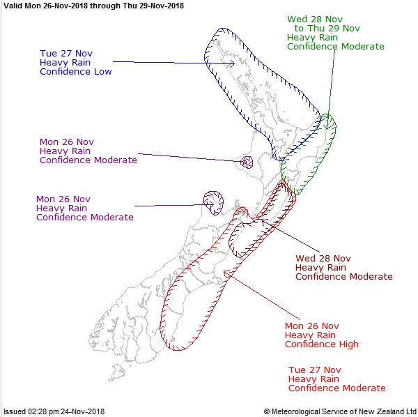
Meanwhile, many Kiwis will experience some wet and wild weather today, with thunderstorms and heavy rain forecast for the upper North Island and eastern South Island.
A deep low crawling in from the west is bending wet northeasterlies across the country. The slow-moving system will last for days.
MetService says there is high confidence that rainfall accumulations will reach warning criteria in Dunedin, North Otago and Canterbury on Monday, lowering to moderate on Tuesday.
The general sogginess follows a late battering of wintry weather this week where snow fell on alpine roads and Mount Cook village shivered in an overnight low of -2degC.
Rain is forecast today from Northland to Otago, with only Southland, and in the afternoon Westland, expected to see much sun.
MetService forecaster Ravi Kandula said that a heavy-rain "watch" was in place for North Otago from 9am to 6am tomorrow.
Further north, in Bay of Plenty and Rotorua there was the potential for "warning amounts" of rain - 50mm in the 12-hour period - to accumulate, Kandula said.
Heavy-rain watches were also issued for Northland, Auckland, Great Barrier Island and Coromandel Peninsula, eastern Marlborough and the Canterbury plains and high country.
Thunderstorms are possible in many North Island areas and temperatures should mostly be in the high teens or early 20s, and up to 23C in Auckland.
The South Island's east coast joins in the dousing today but temperatures are predicted to be down in the mid-teens.
Invercargill looks likely to escape the rain, with a forecast of fine breaks and 19C today.
Kandula said the "very slow moving" weather system would control our weather until about Wednesday, when it would start to move further east.


