
PHOTO
The Head Start pathways directive has come and gone with little to show for it in the South Island.
The only truly unified proposals to come out of it were those submitted by the Kaikōura/Marlborough and the Waitaki/ Waimate/Mackenzie/Timaru groupings.
In most other instances, districts struggled to find unity within the time available.
This resulting in last minute conflicting proposals and several councils opting out.
Ideally, the government, councils and iwi should have been working together from the start to devise a South Island wide solution.
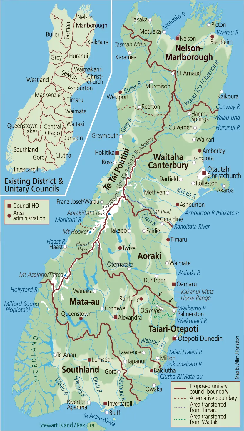
I had drawn up the accompanying map during the Head Start period and then put it aside, but recently a friend and client looked at it and urged me to submit it for publication.
My primary considerations in making the map was to draw boundaries that embraced full catchments.
There were two main reason for doing so, one being that the government has directed that the new entities take on regional responsibilities, such as environmental, and natural resources management.
The other being that oversight of full catchments will be necessary in regard to planning for and dealing with many aspects of climate change.
In the end I reduced the number of entities from 27 (20 district, 3 unitary and 4 regional councils) to seven unitaries as follows:
NELSON-MARLBOROUGH (est. pop: 165,240)
This entity would incorporate the Kaikōura, Marlborough and Nelson councils' territories and the majority of the Tasman council's lands.
The balance of the latter, constituting the upper Buller River catchment (a hangover from the old county days), would be transferred to Te Tai Poutini.
TE TAI POUTINI (est. pop: 38,780)
Te Tai Poutini would be put together by merging the Westland, Grey and Buller districts and, as mentioned above, acquiring the upper Buller River catchment.
I did wonder about its viability however, so I considered incorporating the Buller section into Nelson-Marlborough and splitting the remainder between Waitaha Canterbury and Mata-au (see red dotted lines).
But, with Coasters' political identity at stake, I thought better of it.
In the long term, however, climate change will greatly affect the region. For instance, it would not take much of sea level rise to compromise Westport, Greymouth and Hokitika.
Its destiny may lie in being part of a super council amalgamation or becoming a special government territory.
WAITAHA CANTERBURY (est. pop: 628,350)
Waitaha Canterbury would absorb the districts of Hurunui (with northern boundary adjustments), Waimakariri, Christchurch, Selwyn and Ashburton as well as that part of Timaru district which falls within the Rangitata River catchment (defined by the purple dotted line).
Bearing in mind that regional responsibilities could be carried out by pooled expertise, I initially had ideas of making Ōtautahi Christchurch a separate entity.
But then came the problem of where to draw the boundary. With towns as far away as Amberley and Darfield fast developing as dormitories and traditional farming displaced by intense lifestyle subdivisions in a great many areas, the interface between metro Ōtautahi Christchurch and rural Waitaha Canterbury is now quite blurred.
AORAKI (est. pop: 86,890)
As an amalgamation of the Mackenzie and Waimate districts and the majority of the Timaru and Waitaki council territories, this entity would embrace the Waitaki River catchment and a number of smaller eastern catchments.
The Ashburton district has been included in the above councils' joint amalgamation proposal, but I believe Ashburton's territory, which includes the majority of the Rangitata catchment, belongs in the realm of Waitaha Canterbury.
Likewise, so does that part of Timaru's territory (as mentioned above), which embraces the remainders of the catchment.
Also for catchment reasons, I have ceded that part of Waitaki's territory lying south of the Kakanui Mountains-Horse Range divide (defined by the green dotted line), to Taiari-Ōtepoti.
TAIARI-ŌTEPOTI (est. pop: 138,890)
I was tempted to unite Otago, but ended up dividing it into two entities which I have dubbed Taiari Ōtepoti and Mata-Au.
In creating Taiari-Ōtepoti, Dunedin's boundaries would be extended to take in those parts of the Taiari/Taieri and Waikouaiti River catchments it does not already encompass, as well as the Tokomairiro and Waihemo catchments.
The outstanding reaches of the main Taiari/Taieri watershed would be transferred from the outgoing Central Otago and Waitaki councils, while the catchment of its Waipori tributary and that of the Tokomairiro would be ceded by the outgoing Clutha Council.
The transferred Waitaki territory will also bring with it the outstanding tributaries of the Waikouaiti River and the Waihemo River catchment.
As well, it will allow for Oceania Gold's land holdings, including its 12km long main operations footprint to be wholly contained within Taiari-Ōtepoti.
It should be noted that the Taiari/Taieri, Waikouaiti and Waihemo rivers all have tributaries that interface with the footprint.
Three massive tailings impoundments, two being contained within surface structures and the other in a former mining pit, will remain when the mine closes.
MATA-AU (est. pop: 92,310)
Mata-au would take over the territory of the Queenstown Lakes Council and the majority of the Central Otago and Clutha district lands, to embrace the entire Clutha River/Mata-au catchment.
The Clutha district would also bring with it several small coastal catchments.
It could be said that the Clutha and Queenstown Lakes districts, which bookend the catchment, have little in common and it is true, that in a lighter moment, I thought Auckland would be a better match for the latter.
Overriding everything, however, is the need for the Mata-au catchment to be overseen by one organisation.
SOUTHLAND (est. pop: 104,850)
Southland was a simple matter.
A merger of the present Southland, Invercargill and Gore districts would create a territory that matches that of the present regional entity, Environment Southland.
This proposal aligns with that put forward by the Invercargill City Council.
What of the future?
Given the inevitable issue of runaway climate change, the time will come when further consolidation will be necessary - perhaps in the form of two super councils.
Using my proposal as an example: one grouping Nelson-Marlborough, Waitaha Canterbury and Te Tai Poutini and the other grouping Aoraki, Taiari-Otepoti, Mata-au, and Southland.
As for the present reforms, one thing is for sure: there will be frantic times ahead.
Realising any amalgamation proposal will be highly complex and the powers that be will certainly have their work cut out to have the new entities bedded in prior to the 2028 elections.
- Allan Kynaston has been a self-employed mapmaker since 1998